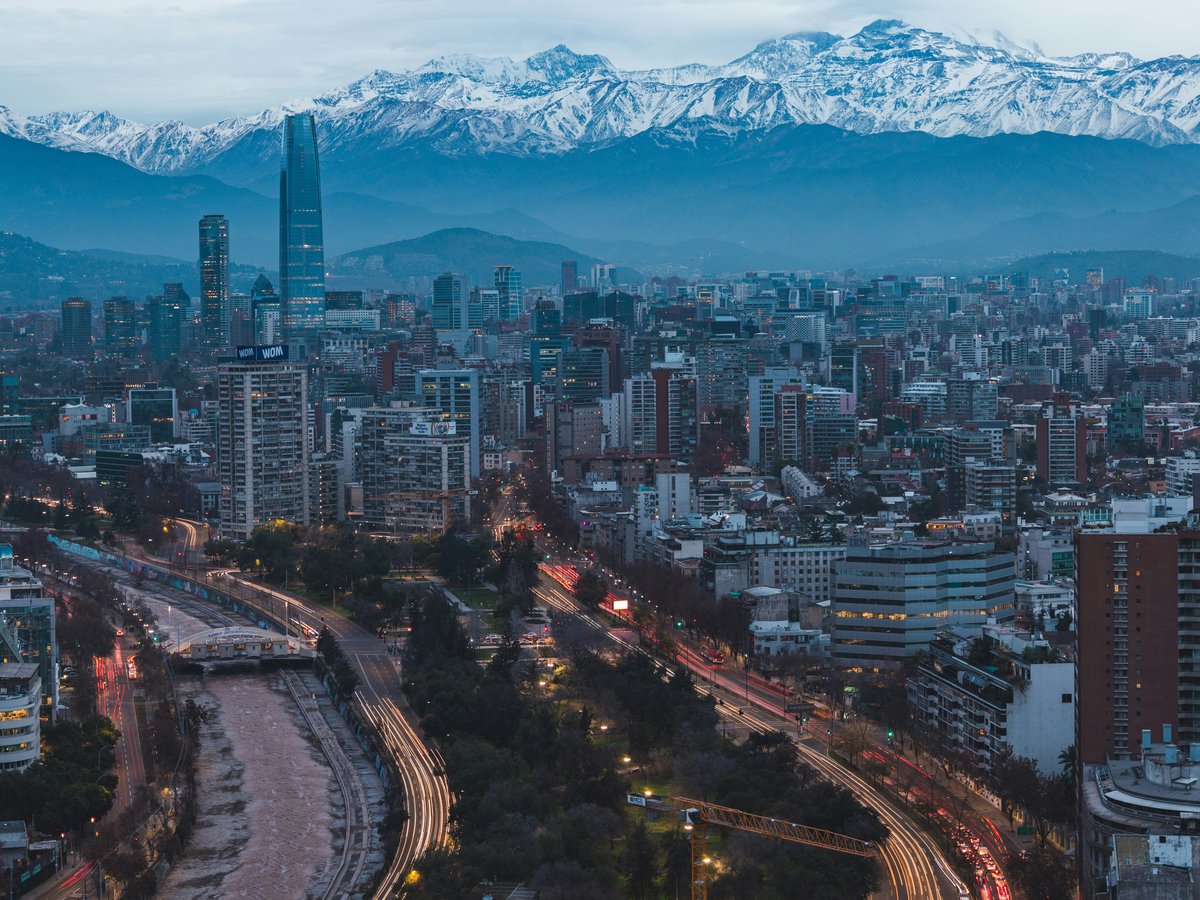
Santiago sits in a wide basin at roughly 520 meters above sea level, with the Andes rising to over 6,000 meters along its eastern edge. The Cordillera de la Costa closes the view to the west, lower but still rugged enough to break up the prevailing Pacific winds. On a clear winter morning, like late August when temperatures can hover around 7°C with high humidity, the snow line on the Andes drops to perhaps 2,500 meters, and the whole eastern skyline turns white. By December the city bakes past 30°C and that snowline retreats above 4,000 meters. This seasonal swing shapes everything you can do outdoors here. The Río Mapocho cuts through the city center, and the Cajón del Maipo, a deep Andean canyon, opens up less than 50 km southeast of downtown. Within the metropolitan area itself, Parque Metropolitano covers around 722 hectares of hillside terrain, making it one of the largest urban parks in South America. Santiago scores 5.8 out of 10 for solo-traveler safety (see the TTDI Solo-Safety Index), which means keeping your wits about you on trails, particularly near the urban fringe where petty theft has been reported near trailheads like Cerro Manquehue's access points in Lo Curro.
Outdoor activities
-
Rock Climbing at Piedra Roja and Los Bronces
Piedra Roja, located near Chicureo on Santiago's northern fringe, offers sport routes in the 5.8 to 5.12 range on volcanic rock. The crags sit at around 900 meters elevation, with south-facing walls that stay cooler in summer. Los Bronces, closer to the Cajón del Maipo entrance, tends to attract more experienced climbers with its multi-pitch options. You'll find bolted routes at Piedra Roja, but bring your own quickdraws and rope, as there is no gear rental on site.
- Difficulty
- Moderate to advanced (5.8 to 5.12 sport grades)
- Duration
- Half day to full day
- Best season
- March through November, when temperatures are manageable and rock stays dry
-
Mountain Biking in Parque Metropolitano and Cerro Pochoco
Parque Metropolitano has gravel roads and a few singletrack trails that wind up Cerro San Cristóbal, climbing about 300 vertical meters from the Pío Nono entrance to the summit. The riding is mellow, mostly fireroad. For something with more teeth, the trails around Cerro Pochoco in La Dehesa offer rocky switchbacks and loose scree sections above 1,200 meters. Bike rental shops along Bellavista serve the Parque Metropolitano crowd, with rates typically running 8,000 to 15,000 CLP per half day.
- Difficulty
- Easy (Parque Metropolitano roads) to moderate-hard (Pochoco singletrack)
- Duration
- 2 to 4 hours
- Best season
- September through May, avoiding the brief rainy windows in June and July
-
Skiing and Snowboarding at Valle Nevado, La Parva, and El Colorado
Three ski resorts cluster between 2,800 and 3,600 meters elevation, all within about 60 km of downtown Santiago via the Farellones road. Valle Nevado is the largest, with around 40 runs and 900 vertical meters of skiable terrain. La Parva sits slightly lower and tends to be less crowded midweek. El Colorado connects to Farellones village and is likely the most accessible for beginners. Day passes at Valle Nevado currently run around 50,000 to 65,000 CLP depending on the date. The road up can require snow chains after storms, and it closes to uphill traffic after 12:00 on busy weekends.
- Difficulty
- Beginner to expert depending on resort and run
- Duration
- Full day
- Best season
- Late June through early October, with the most reliable snow in July and August
-
Paragliding from Cerro Manquehue Area
Tandem paragliding launches operate from several points along the precordillera east of Santiago, with Cerro Manquehue's ridgeline and the slopes near Lo Barnechea being common launch sites at around 1,400 to 1,600 meters. Flights typically last 15 to 30 minutes and land in open fields below. Expect to pay roughly 60,000 to 90,000 CLP for a tandem flight with a certified pilot. The thermals are strongest in the warmer months, which also means longer flight times.
- Difficulty
- No experience needed for tandem flights
- Duration
- 15 to 30 minutes airborne, plus transport
- Best season
- October through March, when afternoon thermals are most reliable
-
Trail Running in the Precordillera
The foothills east of Santiago, particularly in the communes of Lo Barnechea and La Reina, have a growing network of trails between 800 and 1,800 meters elevation. The route from the Sendero de Chile trailhead near La Ermita up toward the ridgeline of Cerro Carbón covers about 10 km round trip with 600 meters of elevation gain. Trail conditions tend toward loose gravel and exposed ridgelines, so ankle-supporting shoes help. Santiago's trail running community organizes group runs most Saturday mornings.
- Difficulty
- Moderate to strenuous depending on elevation gain
- Duration
- 1.5 to 3 hours
- Best season
- March through May and September through November, avoiding midsummer heat
-
Horseback Riding in Cajón del Maipo
Several outfitters in the village of San José de Maipo, about 48 km southeast of central Santiago, run half-day and full-day horseback rides into the Andean foothills. Routes follow the Río Maipo valley and climb into side canyons with views toward the volcanic peaks. Rides typically cost 35,000 to 55,000 CLP per person for a half day. The horses are well adapted to the rocky terrain, and no prior riding experience is required for the gentler routes.
- Difficulty
- Easy to moderate
- Duration
- 3 to 7 hours
- Best season
- October through April, when snowmelt has cleared the valley trails
Day hikes
-
Cerro Manquehue (1,638 m)
Santiago's most popular summit hike starts from the Lo Curro neighborhood in Lo Barnechea. The standard route gains about 900 meters over roughly 5 km one way, with the lower half passing through sparse shrubland and the upper portion crossing exposed rock. You'll likely share the trail on weekends. The summit offers views of the entire Santiago basin to the west and Andean peaks to the east. Start early in summer, as the trail has almost no shade above 1,000 meters.
- Difficulty
- Moderate to strenuous (sustained uphill, some scrambling near the top)
- Duration
- 4 to 6 hours round trip
- Best season
- April through November, when temperatures stay below 25°C at the trailhead
-
Cerro Pochoco (1,590 m)
A shorter but steeper alternative to Manquehue, Cerro Pochoco starts from the La Dehesa area and climbs about 700 meters over 3.5 km. The trail surface is rocky and eroded in sections, with a few spots requiring hands on rock. Mind you, the descent can be harder on the knees than the climb. The trailhead area has limited parking, and getting there by public transit means a long walk from the nearest bus stop.
- Difficulty
- Moderate-strenuous (steep grades, loose rock sections)
- Duration
- 3 to 5 hours round trip
- Best season
- March through November
-
Embalse El Yeso and Surrounding Ridges
The turquoise reservoir at Embalse El Yeso sits at 2,500 meters in the upper Cajón del Maipo, about 90 km from Santiago. The drive alone takes roughly 2 hours each way. From the reservoir's edge, ridge walks of varying lengths lead to viewpoints above 3,000 meters. The water color comes from glacial flour suspended in snowmelt. No swimming is permitted, as the reservoir supplies part of Santiago's drinking water. The access road is unpaved for the last 20 km and can be impassable after heavy snow.
- Difficulty
- Easy (lakeshore walk) to moderate (ridge scrambles above 3,000 m)
- Duration
- Full day including 4 hours driving
- Best season
- November through April, when the road is reliably open
-
Sendero Yerba Loca (Santuario de la Naturaleza Yerba Loca)
This protected area northeast of Santiago, accessed through Lo Barnechea, follows a valley along the Estero Yerba Loca stream to about 2,800 meters. The trail is well marked for the first 8 km, passing through Andean scrub and, in spring, carpets of wildflowers. Beyond the refugio at Piedra Carvajal, the route becomes less defined and enters more serious mountain terrain. CONAF manages access and charges a small entrance fee, currently around 3,000 CLP.
- Difficulty
- Easy to moderate for the first 8 km, strenuous beyond Piedra Carvajal
- Duration
- 5 to 8 hours round trip depending on turnaround point
- Best season
- October through May
-
Cerro Provincia (2,750 m)
One of the more demanding day hikes near Santiago, Cerro Provincia starts from the Arrayán sector in Lo Barnechea and climbs nearly 2,000 vertical meters. The lower slopes pass through eucalyptus groves before transitioning to native scrub. Above 2,200 meters the terrain opens up to exposed ridgeline with loose scree. Expect to spend 8 to 10 hours on this one if you go for the summit. Carry at least 3 liters of water per person, as there is no reliable water source above the first hour.
- Difficulty
- Strenuous (high elevation gain, long exposure, route-finding above treeline)
- Duration
- 8 to 10 hours round trip
- Best season
- December through March, when snow has melted above 2,500 m
-
Parque Nacional La Campana (Sendero al Cerro La Campana, 1,828 m)
About 110 km northwest of Santiago near the town of Olmué, La Campana is the peak Charles Darwin climbed in August 1834 during the Beagle voyage. The standard trail from Sector Granizo gains roughly 1,500 meters over 7 km. The lower sections pass through the last remaining high-altitude Chilean palm (Jubaea chilensis) groves, some trees over 1,000 years old. CONAF limits daily visitors and closes the gate at capacity, so arriving before 09:00 on weekends matters.
- Difficulty
- Strenuous (steep, sustained, rocky upper section)
- Duration
- 6 to 9 hours round trip
- Best season
- March through November, avoiding midsummer heat on the exposed upper slopes
Water activities
-
White Water Rafting on the Río Maipo
The Río Maipo runs through the Cajón del Maipo canyon and offers Class II to III rapids between San José de Maipo and the narrows near San Alfonso, roughly a 12 km stretch. Several outfitters in San José de Maipo run half-day trips that include gear, transport from town, and a guide. Expect to pay around 25,000 to 40,000 CLP per person. Water levels peak in November and December from snowmelt, which pushes some sections to Class III+. By late February, the flow drops and the rapids mellow considerably.
- Difficulty
- Class II to III (higher in peak snowmelt)
- Duration
- 3 to 4 hours on the water
- Best season
- October through February for best flow
-
Kayaking on the Río Mapocho (Urban Section)
The canalized section of the Río Mapocho through central Santiago has been cleaned up enough in recent years to permit recreational paddling on calmer days, though this is still more of a novelty run than a wilderness experience. Kayak clubs operate from put-ins near Parque de los Reyes and run downstream sessions. The water quality has improved since the 2010s treatment plant expansions, but you still would not want to swim in it. Bring a dry bag for your phone.
- Difficulty
- Beginner to intermediate depending on flow
- Duration
- 1 to 2 hours
- Best season
- November through March, when flows are manageable
-
Swimming and Beach Day at the Pacific Coast (Viña del Mar or Algarrobo)
The closest Pacific beaches to Santiago sit about 120 km west. Viña del Mar's Playa Reñaca tends to be the most popular, with coarse sand and cold water year-round (the Humboldt Current keeps surface temperatures around 14 to 17°C even in January). Algarrobo, about 100 km to the southwest, is somewhat quieter. San Alfonso del Mar in Algarrobo once held the Guinness record for the world's largest swimming pool at 1,013 meters long, though it has had access restrictions in recent years. The drive from Santiago takes roughly 90 minutes on Ruta 68 without traffic.
- Difficulty
- Easy (beach swimming, cold water tolerance needed)
- Duration
- Full day trip
- Best season
- December through March for warmest water and weather
-
Stand-Up Paddleboarding at Laguna Carén
Laguna Carén, located about 25 km west of central Santiago near Pudahuel, offers flat-water paddleboarding on a calm reservoir. The wind tends to pick up after noon, so morning sessions are smoother. A few operators rent boards by the hour for around 8,000 to 12,000 CLP. The laguna is surrounded by open scrubland, and the water is clean enough for contact sports, though nobody would call it crystal clear.
- Difficulty
- Beginner-friendly on calm mornings
- Duration
- 1 to 3 hours
- Best season
- September through April
-
Fly Fishing in the Upper Cajón del Maipo Tributaries
Smaller streams feeding the Río Maipo above San José de Maipo hold brown and rainbow trout introduced in the early 1900s. The season runs from the second Friday of October through the first Sunday of April, as regulated by Chile's Servicio Nacional de Pesca (Sernapesca). You need a recreational fishing license, currently around 5,000 CLP for a 30-day permit. The best stretches are 60 to 80 km from Santiago, up narrow side valleys where the water runs cold and clear even in mid-summer.
- Difficulty
- Intermediate (requires some casting skill and wading)
- Duration
- Half day to full day
- Best season
- November through February for best insect hatches
Parks & gardens
-
Parque Metropolitano de Santiago (Cerro San Cristóbal)
FreeThis 722-hectare park sprawls across several hilltops on Santiago's north side. The funicular railway has run since 1925, climbing from the Bellavista neighborhood entrance near Pío Nono to the summit at 880 meters, where a 14-meter statue of the Virgen de la Inmaculada Concepción stands. The Japanese Garden, opened in 1997, sits in a quieter section on the park's western slope. Walking trails loop through native sclerophyll forest with quillay and peumo trees.
Highlights: Funicular railway (operating since 1925), summit mirador, Japanese Garden, Piscina Tupahue (public pool open November through March), Jardín Botánico Mapulemu
-
Santa Lucía Hill
FreeThis rocky outcrop rises about 69 meters above the surrounding streets in downtown Santiago. Pedro de Valdivia founded the city here in 1541. The current landscaping, with its winding stone stairways and terraced gardens, dates to an 1872 renovation led by Benjamín Vicuña Mackenna. It is compact enough to walk in under an hour, but the stone paths can be slippery after rain. The Castillo Hidalgo near the top hosts occasional events.
Highlights: Castillo Hidalgo, Terraza Neptuno fountain, 360-degree city views from the summit terrace, Vicuña Mackenna-era stone balustrades
-
Parque Forestal
FreeA narrow strip of green runs along the south bank of the Río Mapocho for about 10 blocks between the Mercado Central area and Plaza Italia (now Plaza Dignidad). The park was designed in 1900 by the French landscape architect Georges Dubois as part of the city's canalization of the Mapocho. Tall plane trees shade the central path, and on weekends the walkways fill with joggers, dog walkers, and families. The Chilean National Museum of Fine Arts, founded in 1880, sits at the park's eastern end inside the neoclassical Palacio de Bellas Artes.
Highlights: Palacio de Bellas Artes, weekend artisan market near Lastarria, mature plane tree canopy along the central promenade
-
Parque Bicentenario de Vitacura
FreeOpened in 2007 to mark Chile's independence bicentennial, this 30-hectare park in the Vitacura commune has two artificial lagoons stocked with flamingos and black-necked swans. The paths are flat and paved, good for strollers and wheelchairs. A skate park and children's play area sit on the southern end. The grass lawns fill up on Sunday afternoons, especially in spring when the cherry trees along the eastern edge bloom.
Highlights: Flamingo lagoons, cherry blossom row (peaks in September and October), sculpture installations, skate park
-
Parque O'Higgins
FreeOriginally called Parque Cousiño when it opened in 1873, this 80-hectare park sits south of the Alameda. It includes the Pueblito de O'Higgins, a small recreation village with food stalls, and an artificial lake where you can rent paddle boats for a few thousand pesos. The park hosts Fiestas Patrias celebrations each September, when temporary fondas (food and music pavilions) take over large sections. During quiet months it is one of the more spacious green areas for running.
Highlights: Pueblito de O'Higgins, paddle boat lake, Fiestas Patrias fondas (mid-September), Fantasilandia amusement park adjacent on the south side
-
Quinta Normal Park
FreeFounded in 1842, Quinta Normal covers about 36 hectares in the Quinta Normal commune west of the city center. The park holds several museums within its grounds, including the Chilean National Museum of Natural History, which dates to 1830 and is one of the oldest in Latin America. A small boating lagoon sits near the park's center, and mature native trees provide good shade through summer.
Highlights: Chilean National Museum of Natural History (founded 1830), boating lagoon, greenhouse with subtropical plantings, wide gravel paths for jogging
Practical tips
- Sun Protection
- Santiago sits at roughly 33°S latitude, and the UV index regularly hits 11 or higher between November and March due to the thin ozone layer over the Southern Cone. Wear SPF 50+ sunscreen, a wide-brimmed hat, and UV-blocking sunglasses even on hikes that start in cloud cover. At elevations above 2,000 meters, UV exposure increases about 10% per 1,000 meters, so the ski resorts and high hikes demand reapplication every 90 minutes.
- Water and Hydration
- Tap water in Santiago is drinkable and comes from Andean snowmelt processed by Aguas Andinas. Carry at least 2 liters per person for any hike under 4 hours, and 3 liters or more for longer routes like Cerro Provincia. Do not drink from streams on popular trails without filtering. In the Cajón del Maipo, water from higher-elevation tributaries above the village line is generally cleaner, but Giardia has been reported.
- Trail Conditions and Footwear
- Most trails in Santiago's precordillera are unimproved, meaning loose gravel, exposed rock, and eroded switchbacks. Ankle-high hiking boots with stiff soles make a real difference on the steeper descents like Cerro Pochoco. After winter rains (May through August), some lower trails turn to clay mud, and the higher routes may carry snow patches well into November. Check with CONAF or local hiking groups on social media before heading to the Andes routes.
- Gear and Layering
- Santiago's Andean proximity creates fast weather changes, especially above 1,500 meters. Morning temperatures in the foothills can sit around 8 to 10°C even in October, then climb past 25°C by midday. Carry a wind shell and a mid-layer fleece on any hike above the urban parks. For the ski resorts, rent gear in the Farellones road shops rather than at the resort base, where prices run 20 to 30% higher.
- Getting to Trailheads
- Most trailheads in Lo Barnechea (Manquehue, Pochoco, Yerba Loca) are reachable by the Santiago Metro's Línea 1 to Escuela Militar, then a bus or taxi east. Budget 45 to 75 minutes from the city center. For the Cajón del Maipo, buses leave from the Bellavista de La Florida Metro station roughly every 30 minutes. Embalse El Yeso and the upper canyon require a private vehicle or organized tour, as public transport does not go past San José de Maipo.
- Currency and Trail Fees
- Chile uses the peso (CLP), and with 1 USD buying roughly 913 CLP, most trail fees and gear rentals remain affordable for international visitors. CONAF-managed parks like Yerba Loca and La Campana accept cash only at the entrance. ATMs are common in Santiago but nonexistent past San José de Maipo. Carry small bills, as trailhead vendors rarely break 20,000 CLP notes.
FAQ
What is the best time of year for hiking near Santiago?
The shoulder seasons, roughly March through May and September through November, offer the best balance of mild temperatures and dry conditions for hiking Santiago's precordillera trails. Midsummer (December through February) brings clear skies but intense heat, especially on south-facing slopes below 1,500 meters. Winter months from June through August close many higher routes due to snow, though Cerro Manquehue and Cerro Pochoco remain accessible year-round at lower elevations.
Can I do outdoor activities in Santiago without a car?
Several popular trailheads are reachable by Metro and bus. Cerro Manquehue and Cerro Pochoco both have trailhead access from Lo Barnechea buses that connect to Línea 1. Parque Metropolitano is directly accessible from the Baquedano or Pedro de Valdivia Metro stations. For the Cajón del Maipo, public buses from Bellavista de La Florida station reach San José de Maipo in about an hour. That said, destinations like Embalse El Yeso, La Campana, or the coast require either a rental car or joining an organized tour.
Is Santiago safe for solo outdoor activities?
Santiago scores 7.2 out of 10 for family friendliness (see the TTDI Family-Friendliness Index), and families regularly use parks like Parque Metropolitano and Parque Bicentenario. For solo hikers, the main concerns are petty theft at trailhead parking areas and isolation on longer Andean routes. Hiking with at least one partner is advisable on full-day routes like Cerro Provincia. On popular trails such as Manquehue, you will likely encounter other groups throughout the day on weekends. Keep valuables out of sight in parked vehicles.
What should I pack for a day hike from Santiago?
At minimum, bring 2 to 3 liters of water, sun protection (SPF 50+, hat, sunglasses), a wind-resistant shell layer, snacks with electrolytes, and sturdy hiking boots. A portable phone charger is useful, as cell reception drops on many Andean trails above 1,200 meters. Trekking poles help on the loose, steep descents common on Pochoco and Provincia. In the cooler months from May to September, add a fleece mid-layer and a waterproof jacket for unexpected rain.
Are there any outdoor activities suitable for beginners in Santiago?
Parque Metropolitano offers gentle walking trails and paved roads for cycling with views across the city. Santa Lucía Hill is a short climb in the city center that takes under an hour. Stand-up paddleboarding at Laguna Carén is calm enough for first-timers on morning sessions. Tandem paragliding flights require no experience and operate from the eastern foothills. For a mellow beach day, the Pacific coast sits about 90 minutes west, though the cold Humboldt Current water takes some adjusting to.
Where can I find outdoor gear shops in Santiago?
The Barrio Italia neighborhood (Avenida Italia between Irarrázaval and Diagonal Paraguay) has several outdoor and adventure shops including branches of Doite and Lippi, two Chilean brands with locally designed gear. The Alto Las Condes and Parque Arauco malls carry The North Face and Columbia stores. For budget options, the Patronato market area sometimes stocks basic hiking gear. Rental shops for skiing are concentrated on the Farellones access road, particularly around the Curva 15 area.
Outdoor experiences in Santiago
 Free cancellation
 Santiago Skyline: Cable Car & San Cristobal Walking Tour
Outdoor experience: 2.5 hours, free cancellation.
via Viator Free cancellation
 Tour 1 Day Portillo and Lagoon of the Inca from Santiago Picnic
Outdoor experience: free cancellation.
via Viator Free cancellation
 Tour from Santiago 1 day in Farellones and Panoramic Nevado Valley
Outdoor experience: free cancellation.
via Viator Free cancellation
 Andes Day Lagoon - Embalse del Yeso, Cajón del Maipo.
Outdoor experience: 9 hours, free cancellation.
via Viator Free cancellation
 A Day in Valparaíso and Viña del Mar: Costa and Culture of Chile
Outdoor experience: free cancellation.
via Viator Free cancellation
 Tour Reservoir the plaster and Cajon del Maipo
Outdoor experience: 10 hours, free cancellation.
via Viator
From Santiago to the Andes: 4x4, horseback riding, waterfall visit and barbecue
Outdoor experience: 10 hours.
via Viator
Cerro El Plomo Trekking Adventure with Expert Guides 3 days
Outdoor experience: 3 days.
via Viator Free cancellation
 Penguin Watching Navigation Cachagua Lunch From STGO Private Tour
Outdoor experience: free cancellation.
via Viator Free cancellation
 Cajon Del Maipo with Lunch and Visit to One Winery
Outdoor experience: free cancellation.
via Viator Free cancellation
 Fr STGO: WILD PENGUINS, SEALION, SANDBOARD, PARAGLIDING & PICNIC
Outdoor experience: free cancellation.
via ViatorLast verified by automated review (v1.7.2) on . What is automated review?