St. Augustine sits on a narrow strip of land between the Matanzas River and the Atlantic Ocean, about 40 miles south of Jacksonville on Florida's northeast coast. The city was founded in 1565, and that age shows in the coquina walls and the live oaks draped with Spanish moss along San Marco Avenue. But step past the historic district and you'll find salt marsh, barrier island, and tidal creek systems that run for miles in either direction along the Intracoastal Waterway. The outdoor character here tends to be quieter than South Florida. You're not climbing mountains. You're paddling through oyster bars at dawn on the Matanzas, or walking a flat sandy trail through maritime hammock at Anastasia State Park while brown pelicans dive offshore. Summer heat and humidity are real, routinely above 90°F with 80% humidity from June through September. October through April is the sweet spot for most outdoor activities, with daytime temperatures between 55°F and 78°F and lower mosquito pressure. The salt air carries the smell of pluff mud at low tide, and on calm mornings the Matanzas River goes glassy enough to mirror the Bridge of Lions.
Outdoor activities
-
Road cycling on Scenic A1A
State Road A1A runs south from Vilano Beach through Butler Beach and beyond, with a paved shoulder wide enough for road bikes along most stretches. The 15-mile section from Vilano to Crescent Beach is flat with occasional gentle grades over bridge crossings. You'll pass Anastasia State Park, the St. Augustine Lighthouse area, and long stretches of dune line. Traffic tends to pick up on weekends between the Beach Boulevard intersection and A Street, so early morning starts work best. The pavement is generally smooth, though sand drift can narrow the shoulder after storms.
- Difficulty
- Moderate (flat terrain, but road traffic requires experience)
- Duration
- 2-3 hours for a 30-mile round trip
- Best season
- October through April, when humidity drops and tourist traffic thins
-
Birdwatching at GTM Research Reserve
The Guana Tolomato Matanzas National Estuarine Research Reserve stretches north of St. Augustine along the Tolomato River. The reserve's 73,000 acres hold salt marsh, mangrove, and coastal scrub habitat. The South Ponte Vedra entrance off A1A has a visitor center and a 0.5-mile boardwalk loop through marsh. Roseate spoonbills show up in the shallows during warmer months, and in winter you might spot northern harriers working the grass flats. Painted buntings appear from late April through August. The mudflats at low tide draw hundreds of shorebirds. Bring a scope if you have one.
- Difficulty
- Easy (flat boardwalk and sandy trails)
- Duration
- 1-3 hours depending on how many species you chase
- Best season
- November through March for migratory shorebirds, April through August for painted buntings
-
Fishing the Matanzas Inlet
Matanzas Inlet sits about 15 miles south of downtown St. Augustine where the Matanzas River meets the Atlantic. The current rips through on tidal changes, which makes it productive for redfish, flounder, and sheepshead depending on the season. You can wade-fish the sandbar on the south side at low tide, though the footing shifts. The inlet jetty on the Anastasia Island side sees regular action from shore anglers casting into the channel. A Florida saltwater fishing license runs about $17 for residents, $47 for non-residents for a 7-day permit. Bait and tackle are available at Fisherman's Landing off A1A.
- Difficulty
- Easy to moderate (wading requires awareness of tidal currents)
- Duration
- Half day to full day
- Best season
- September through November for redfish run, year-round for sheepshead
-
Surfing at St. Augustine Beach
St. Augustine Beach picks up northeast swells well, and the sandbars shift enough to produce decent breaks when conditions line up. The pier at St. Johns County Ocean Pier tends to concentrate waves on either side. Typical wave height runs 2-4 feet on good days, though nor'easters in fall and winter can push it higher. The water temperature drops to around 58°F in January, warm enough for a 3/2 wetsuit. Summer brings smaller, mushier surf and bathtub-warm water around 82°F. Pit Surf Shop on A1A Beach Boulevard rents boards starting around $25-35 per day. Worth noting, the beach drives section south of the pier allows vehicle access, so watch for cars if you're walking with a board.
- Difficulty
- Beginner-friendly on small days, intermediate on overhead swells
- Duration
- 2-4 hours per session
- Best season
- September through March for consistent swell
-
Trail running at Faver-Dykes State Park
Faver-Dykes State Park is about 15 miles south of St. Augustine off US-1, and it feels a world apart from the tourist strip. The park's trail network runs through pine flatwoods and along Pellicer Creek, a tannin-dark waterway that winds through the interior. The main loop trail covers roughly 5 miles on packed sand and pine needle surface. The footing is mostly flat with some root exposure. Deer flies can be vicious from May through August. You'll likely see gopher tortoises along the trail edges and possibly a bald eagle near the creek. Park entry is $5 per vehicle.
- Difficulty
- Easy to moderate (flat, but soft sand sections slow your pace)
- Duration
- 1-2 hours for the main loop at running pace
- Best season
- October through March for tolerable bug pressure and cooler temperatures
-
Stand-up paddleboarding on the Matanzas River
The Matanzas River behind downtown St. Augustine offers sheltered flatwater paddling with views of the Castillo de San Marcos and the Bridge of Lions. On calm mornings the water barely ripples, and dolphins frequently surface within a few paddle strokes of the seawall. St. Augustine Eco Tours and other outfitters near the bayfront rent SUP boards starting around $30-40 for 2 hours. The stretch between the Bridge of Lions and the Lighthouse is about 1.5 miles one way. Mind the boat channel traffic, especially on weekends. Tidal current can be surprisingly strong near the bridge pilings.
- Difficulty
- Beginner-friendly in calm conditions
- Duration
- 1.5-3 hours
- Best season
- March through May and October through November for mild weather and manageable winds
Day hikes
-
Anastasia State Park Ancient Trail
This loop trail runs through maritime hammock forest on Anastasia Island. The canopy of live oaks, sabal palms, and red cedar keeps most of the trail shaded. The surface is packed sand with some shell fragments. The loop is roughly 1 mile, and you can extend it by connecting to the beach access trails that lead east to the Atlantic. The hammock interior stays cooler than open beach, and you'll hear Carolina wrens and cardinals in the understory. A few interpretive signs mark plant species. It's flat the whole way.
- Difficulty
- Easy (flat, well-marked, sandy surface)
- Duration
- 30-45 minutes for the loop, 1.5-2 hours if you add the beach extension
- Best season
- October through April for comfortable temperatures and fewer mosquitoes
-
Guana River State Park trails
The Guana River section of the GTM Reserve, north of St. Augustine off A1A, has several interconnected trails running through scrub, pine flatwoods, and along the Guana River dam. The main trail from the dam parking area follows the river south on a wide sandy path. It's flat and exposed in stretches, so the sun can be relentless in summer. A side trail loops through scrub habitat where Florida scrub-jays have been spotted. The combined out-and-back from the dam to the southern marsh overlook covers about 4-5 miles. Park entry is $3 per person at the honor box.
- Difficulty
- Easy to moderate (flat, but sandy stretches and sun exposure add effort)
- Duration
- 2-3 hours for the full out-and-back with stops
- Best season
- November through March, when the scrub-jays are active and the heat relents
-
Faver-Dykes State Park Pellicer Creek Trail
This trail follows the edge of Pellicer Creek through pine flatwoods and hardwood hammock. The creek water runs the color of strong tea from tannins. You'll hear woodpeckers working the pines. The trail surface alternates between packed sand and pine needles. Some low-lying sections can flood after heavy rain, so check conditions if there's been a recent storm. The canopy opens and closes as you pass between flatwoods and hammock sections. The full out-and-back is roughly 5-6 miles from the trailhead parking area. Park entry is $5 per vehicle.
- Difficulty
- Moderate (length and occasional soft sand, plus potential wet sections)
- Duration
- 2.5-3.5 hours at a steady hiking pace
- Best season
- October through February for low water and fewer biting flies
-
Fort Matanzas National Monument Trail
Fort Matanzas sits on Rattlesnake Island in the Matanzas River, about 14 miles south of downtown St. Augustine. The visitor center side on A1A has a short boardwalk nature trail, roughly half a mile, that loops through coastal hammock and along the riverbank. The trail is flat and well-maintained. A free ferry crosses to the fort itself, which is a small 1742 Spanish watchtower made of coquina. The whole visit including the ferry ride and fort exploration takes about 2 hours. No entry fee, no reservations needed for the ferry.
- Difficulty
- Easy (flat boardwalk, half-mile loop)
- Duration
- 1.5-2 hours including the free ferry and fort visit
- Best season
- Year-round, though summer afternoons bring thunderstorms by 3 PM
-
Moses Creek Conservation Area
Moses Creek Conservation Area lies about 12 miles south of St. Augustine off US-1, managed by the St. Johns River Water Management District. The trail network covers roughly 5 miles of interconnected loops through pine flatwoods, scrubby flatwoods, and marsh edge. The terrain is flat but the sand can be deep in dry months. Few people come out here, so you might have the trail to yourself on a weekday. The birdlife along the marsh edges is solid, with wading birds visible in the shallows. No facilities at the trailhead beyond a small parking area.
- Difficulty
- Moderate (deep sand, limited shade, no facilities or water)
- Duration
- 2-3 hours for the full loop system
- Best season
- November through March for cooler temperatures and firmer trail surface
Water activities
-
Kayaking Salt Run at Anastasia State Park
Salt Run is a tidal lagoon on the western side of Anastasia State Park. The water is shallow and usually calm, rarely more than 3-4 feet deep. Manatees move through in the cooler months, roughly November through March. Dolphins show up year-round. The park has a kayak and canoe launch near the campground area. You can rent kayaks inside the park from the concessionaire for about $20-30 per hour. Paddling the length of Salt Run and back covers about 3 miles. The muddy bottom can ground you at extreme low tide, so check the tide chart before heading out.
- Difficulty
- Beginner-friendly (sheltered, shallow water)
- Duration
- 1.5-2.5 hours for a leisurely round trip
- Best season
- October through May for manatee sightings and comfortable paddling weather
-
Kayaking the Matanzas River from downtown
Several outfitters along the bayfront in downtown St. Augustine rent kayaks for trips on the Matanzas River. The river is part of the Intracoastal Waterway here, so expect some boat wake traffic, especially on weekends. Paddling south from the bayfront toward the lighthouse, you pass the old seawall and see the backside of the colonial district. The water smells of salt and mud at low tide. Great blue herons stand motionless along the oyster bars. A round trip to the lighthouse area and back is about 3 miles. Tidal currents can work for or against you, so time your launch with the tide if you can.
- Difficulty
- Beginner to intermediate (tidal current and boat traffic require attention)
- Duration
- 2-3 hours
- Best season
- March through May and October through November for mild conditions
-
Swimming at St. Augustine Beach
St. Augustine Beach runs for several miles south from the St. Johns County Ocean Pier. The sand is wide and relatively firm near the waterline. Lifeguards are on duty at the pier area from roughly Memorial Day through Labor Day. Rip currents can develop, especially after storms, so check the posted flag conditions. The water warms to around 80-82°F by July and drops to about 58°F in January. The beach is free and open to the public. Parking near the pier can fill by mid-morning on summer weekends, but spots open up south of A Street.
- Difficulty
- Easy (lifeguarded sections available in summer)
- Duration
- As long as you like
- Best season
- May through October for warm water temperatures above 75°F
-
Eco-tour kayaking through the GTM Reserve
Guided eco-tours run through the salt marshes of the Guana Tolomato Matanzas Reserve, typically launching from points north of St. Augustine near Ponte Vedra or from the Marineland area to the south. The guided trips tend to cover 3-5 miles over 2-3 hours and focus on the salt marsh ecosystem, oyster beds, and bird colonies. St. Augustine Eco Tours is one of the more established operators, with trips starting around $55-65 per person. The marsh channels are narrow and winding, with fiddler crabs covering the mud banks at low tide. Wind can be a factor in the open sections.
- Difficulty
- Beginner to intermediate (guided, but wind and current add challenge)
- Duration
- 2-3 hours for a guided trip
- Best season
- October through April for cooler paddling and active migratory birds
-
Pellicer Creek paddling from Faver-Dykes
Pellicer Creek is a state-designated paddling trail that runs through Faver-Dykes State Park. The creek is narrow and shaded by overhanging oaks and palms. The water is dark with tannins and still enough that reflections look almost solid. You'll likely see turtles stacked on logs and possibly an otter if you're quiet. The put-in at Faver-Dykes is accessible from the park's canoe launch. The creek winds for several miles before it opens into wider marsh. Current is minimal in the upper section. Bring bug spray. The horseflies near the bank can be aggressive in warmer months.
- Difficulty
- Easy to moderate (narrow creek, minimal current, but remote with no bailout points)
- Duration
- 2-4 hours depending on how far you paddle
- Best season
- November through March for fewer insects and comfortable temperatures
Parks & gardens
-
Anastasia State Park
Anastasia State Park covers 1,600 acres on Anastasia Island, about 10 minutes from downtown. The park has 4 miles of undeveloped Atlantic beach backed by sand dunes and sea oats. A tidal lagoon called Salt Run borders the western side. The Ancient Trail loop winds through maritime hammock forest under a canopy of live oaks and red cedar. The interior smells like warm pine and salt. Raccoons are bold here, especially near the campground. The park entrance is off A1A Beach Boulevard, and the $8 per vehicle fee covers the day.
Highlights: Salt Run lagoon for kayak launching, the Ancient Trail loop through maritime hammock, 4 miles of beach, and a 139-site campground that books up months ahead in spring
-
Washington Oaks Gardens State Park
Washington Oaks sits about 20 miles south of St. Augustine on A1A, straddling the road between the Matanzas River and the ocean. The formal gardens on the river side include cultivated beds of camellias, azaleas, and bird of paradise plants set under a canopy of massive live oaks. The ocean side is something different entirely. Coquina rock formations jut from the beach in dark, weathered slabs, carved by tide into shapes that look almost deliberate. Low tide exposes tide pools between the rocks. The garden paths are paved and shaded. Entry runs $5 per vehicle.
Highlights: Coquina rock beach formations, formal ornamental gardens with 1,000+ plant species, the riverside citrus grove, and the historic Owen house grounds
-
Treaty Park
FreeTreaty Park is a 52-acre county park on Wildwood Drive, about 3 miles west of the beach. It has a 2-mile paved multi-use trail that loops through pine flatwoods and around a small pond. The park sees regular use from joggers and dog walkers. There's a playground, picnic pavilions, and open athletic fields. The trail surface is smooth asphalt, flat the whole way. Shade coverage varies. The pine sections are open and sunny, but the hammock stretches along the eastern loop have decent canopy. No entry fee.
Highlights: 2-mile paved loop trail, shaded hammock sections, athletic fields, and a disc golf course along the northern edge
-
St. Augustine Lighthouse and Maritime Museum Grounds
The St. Augustine Lighthouse sits at the north end of Anastasia Island. The grounds surrounding the 165-foot tower include native plantings, interpretive paths, and views across Salt Run toward the historic district. The lighthouse itself dates to 1874. Climbing the 219 steps to the top puts you at a vantage point where you can see down the coast and across the Intracoastal. The grounds have scattered live oaks and the keeper's house from the 1870s. The museum charges $15 for adult admission, which includes the tower climb.
Highlights: 219-step tower climb with panoramic coastal views, 1870s keeper's house, native habitat restoration areas, and maritime archaeology exhibits
-
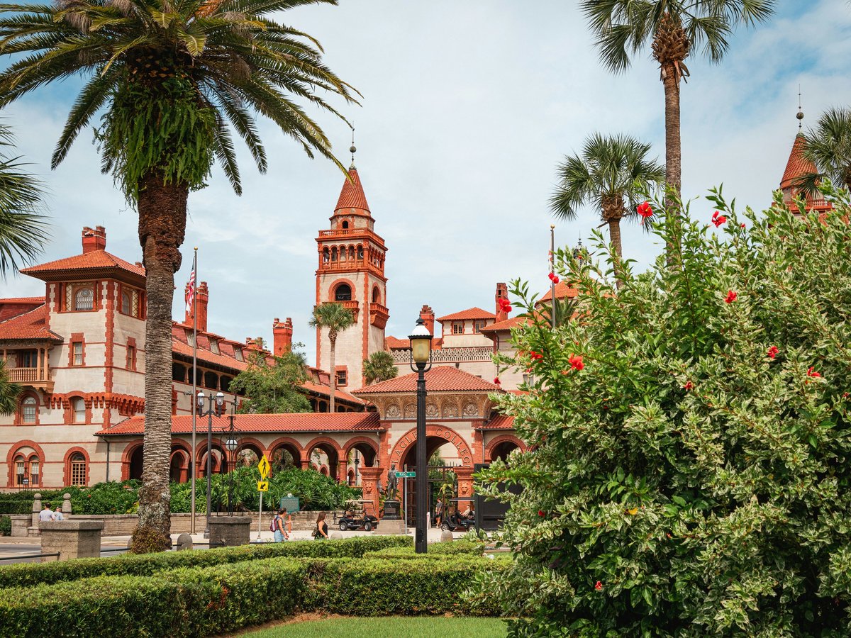
Flagler College Campus
FreeFlagler College occupies the former Hotel Ponce de León, built by Henry Flagler in 1888. The courtyard and surrounding grounds are open to foot traffic and feel like a public garden, with palms, flowering shrubs, and Spanish Renaissance architecture on all sides. The central courtyard has a working fountain and clipped hedgerows. The building's terra cotta detailing and Tiffany stained glass are visible from outside during operating hours. It sits right on King Street in the heart of the historic district.
Highlights: 1888 Ponce de León courtyard with fountain, Spanish Renaissance architecture, Tiffany glass visible through the rotunda, and mature tropical plantings
Practical tips
- Sun protection
- Northeast Florida sun is deceptive, especially on the water where reflection doubles your UV exposure. Wear SPF 50+ and reapply every 90 minutes. A wide-brim hat and UV-rated buff for your neck make a real difference on exposed trails at Guana River or Moses Creek. Sunglasses with polarized lenses cut the glare on the Matanzas River and help you spot sandbars while kayaking.
- Hydration
- Carry at least 1 liter per hour of activity in summer and 0.5 liters per hour in winter. Most trailheads at Faver-Dykes and Moses Creek have no water source, so pack everything you need. The humidity in St. Augustine, often above 80% from June through September, means you sweat more than you realize. Electrolyte tablets are worth adding on any outing over 2 hours in the warmer months.
- Mosquitoes and biting flies
- From May through October, mosquitoes near any standing water or marsh edge will find you within minutes. DEET-based repellent at 25-30% concentration works better than most plant-based alternatives in this environment. Deer flies and horse flies are worst from May through August at inland parks like Faver-Dykes. Wearing light-colored clothing helps, as dark colors seem to attract them more. Early morning outings before 8 AM tend to have the lightest bug activity.
- Tidal awareness
- Tides in St. Augustine run about 4-5 feet on average. Low tide exposes oyster bars that can ground a kayak in Salt Run and the Matanzas River. High tide pushes water into low-lying trail sections at Anastasia State Park's beach access paths. Check the NOAA tide chart for the St. Augustine Beach station before any water activity. The Matanzas Inlet current reverses with the tide and can run fast enough to challenge even experienced paddlers.
- Trail footwear
- Most trails around St. Augustine are sandy, flat, and occasionally wet. Trail runners with decent tread handle the conditions better than hiking boots, which tend to fill with sand. For beach walks, water shoes or sandals with a heel strap work well on the coquina rock sections at Washington Oaks. Flip-flops are a liability on anything beyond a boardwalk. If you're paddling, bring neoprene water shoes or old sneakers you don't mind getting muddy.
- Summer thunderstorms
- From June through September, afternoon thunderstorms roll in almost daily, typically between 2 PM and 5 PM. Lightning is the real danger, especially on open water or exposed beach. Plan water activities for the morning and be off the Matanzas River by early afternoon. If you hear thunder on a trail, the storm is within 10 miles. The storms usually pass within 30-45 minutes, but they can be intense, with heavy rain and wind gusts above 40 mph.
FAQ
What is the best time of year for outdoor activities in St. Augustine?
October through April is the most comfortable window. Daytime temperatures sit between 55°F and 78°F, humidity is lower, and the mosquito population drops off sharply after the first cool snap, usually in late October. Spring break weeks in March can bring crowds to Anastasia State Park and the beaches. November and early December are often ideal, with warm sun, light winds, and thin crowds.
Do I need a car to access outdoor activities in St. Augustine?
For downtown kayaking on the Matanzas River and walking the historic district, no. Several outfitters are on the bayfront within walking distance of most downtown hotels. But Anastasia State Park, Faver-Dykes, Washington Oaks, GTM Reserve, and Moses Creek all require a car. Ride-share service to Anastasia State Park from downtown runs about $8-12 each way, but anything farther south on A1A gets expensive quickly.
Are there any free outdoor activities in St. Augustine?
St. Augustine Beach is free with no entry fee. Fort Matanzas National Monument charges nothing, including the ferry ride to the fort. Treaty Park in the beach area is a free county park with a 2-mile paved trail. The Flagler College campus grounds are open to walkers at no cost. The GTM Reserve's South Ponte Vedra entrance charges $3 per person at an honor box.
Is it safe to swim at St. Augustine Beach year-round?
The ocean is accessible year-round, but conditions vary. Lifeguards patrol the pier area from roughly Memorial Day through Labor Day. Winter water temperatures around 58°F are tolerable for some, but most people stay on the sand from December through February. Rip currents are the primary hazard. Beach flag warnings are posted daily. Purple flags mean marine pests like jellyfish, which show up more often from August through October.
What kind of wildlife might I see outdoors around St. Augustine?
Dolphins are common in the Matanzas River and visible from the bayfront seawall almost daily. Manatees move into Salt Run and the Intracoastal from roughly November through March when water temperatures drop. Gopher tortoises are hard to miss at Faver-Dykes and along A1A shoulders. Roseate spoonbills, great blue herons, and ospreys are regular sights at GTM Reserve. Painted buntings, one of North America's most colorful songbirds, breed in the scrub habitats from late April through August.
Do state parks around St. Augustine require reservations?
Day-use entry at Anastasia State Park, Faver-Dykes, and Washington Oaks is first-come, first-served with no reservation needed. You pay at the gate or honor box. Camping at Anastasia State Park does require a reservation through ReserveAmerica, and sites for peak season weekends from October through April tend to fill 2-3 months in advance. Fort Matanzas ferry runs on a set schedule and does not take reservations.
Last verified by automated review (v1.7.2) on . What is automated review?