What's the must-see thing in Koh Tao?
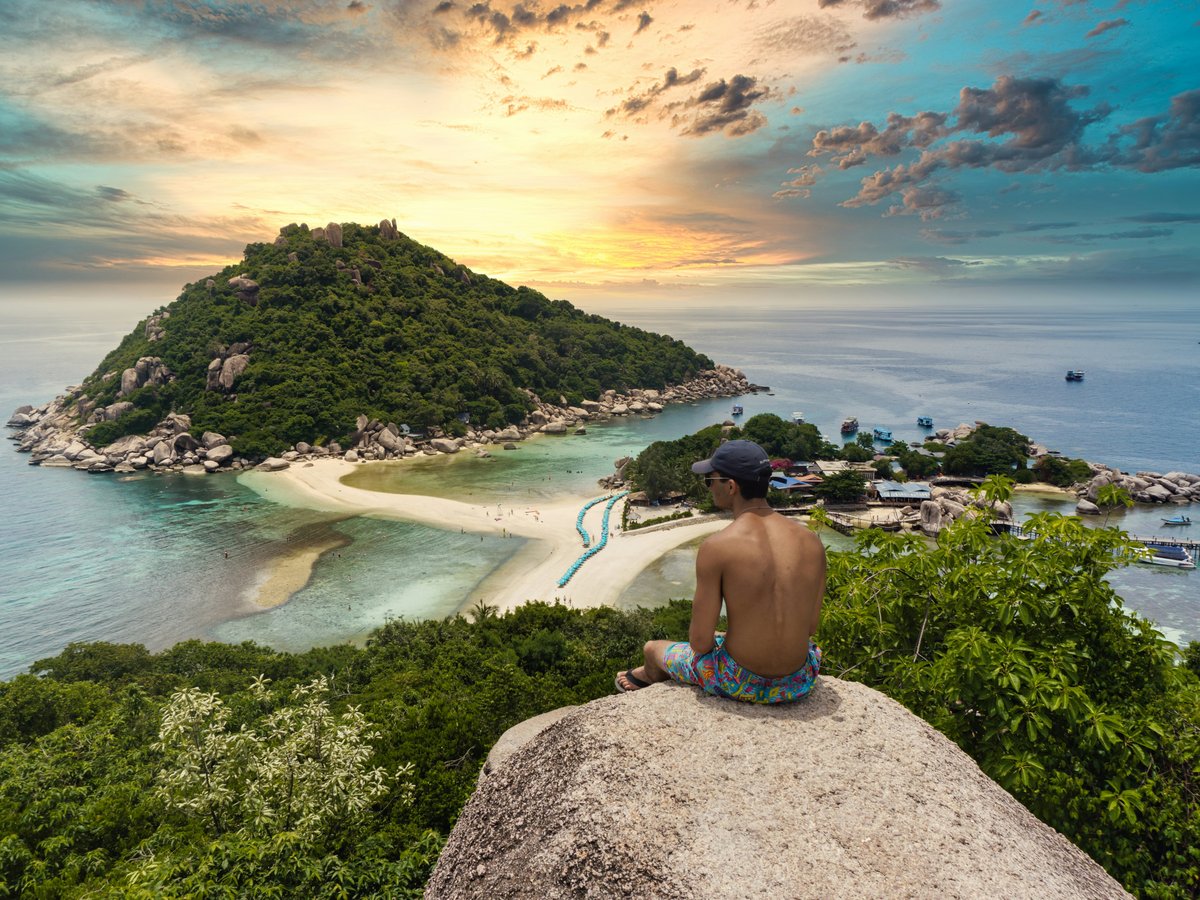
Koh Nang Yuan is the one sight to plan your day around: three granite islets off Koh Tao's northwest coast share a single sandbar, and a 15-minute climb reaches the island's best view. Go early, before the Koh Samui day-tour boats arrive. Entry is currently 100 baht, about $3, and plastic bottles are banned.
Koh Nang Yuan takes the top slot because no other spot on Koh Tao looks like it. The islets sit about 1 km off the northwest tip, and a longtail from the north end of Sairee Beach currently runs roughly 300 to 400 baht return per boat. Arrive by 9am. The Lomprayah catamaran tours from Koh Samui and Koh Phangan tend to land in late morning, and after that the sandbar becomes a line of people waiting for the same photo. The sand on Nang Yuan is coarse and coral-white and squeaks underfoot. The summit path is wooden steps and bare granite, warm to the touch by 10am. From the top you look straight down on the sandbar, with pale green water on both sides. The rangers at the Nang Yuan jetty enforce the bottle ban and check bags. Snorkel the Japanese Gardens beside the sandbar, where hard coral sits in 2 to 5 metres of water.
Getting underwater is your second priority, because Koh Tao certifies more new divers than almost anywhere on earth. A PADI Open Water course takes three to four days and usually costs 10,000 to 12,000 baht; at 33.69 baht to the dollar, that comes to about $297 to $356. Most schools line Sairee and Mae Haad, and many add a cheap dorm bed. Short on time? A one-morning Discover Scuba session, or a snorkel at Ao Leuk on the southeast coast, shows you the same reef fish without the classroom. The road down to Ao Leuk is steep, rutted concrete, and by noon the beach smells of sunscreen and salt. Skip the water on your arrival day. The Lomprayah ferry from Chumphon is a long, rolling ride, and you will have more fun on day two. Signing up at a Sairee dive shop the evening before is normal.
John-Suwan Viewpoint sits above Chalok Baan Kao on the south coast, and the climb takes 15 to 20 minutes over roots and boulders, with a rope helping on one section. A fee of around 50 baht at the time of writing is collected at the Freedom Beach gate. At the summit, Chalok bay opens on one side and Shark Bay on the other. Go at 7am or after 4pm: on 9 October 2026 at 1:45pm it was 28.1°C and overcast, and 73% humidity pushed the felt temperature to 32.7°C. The rocks hold that heat. October is the start of Koh Tao's wet months, which run roughly to December, so longtail trips can cancel on choppy days; keep one flexible day. Overrated? Renting a scooter. The roads to Ao Tanote and Chalok are steep concrete with sand on the bends, and rental shops have a history of damage claims. Take a songthaew taxi from Mae Haad pier instead.
The top three
Koh Nang Yuan
No other spot near Koh Tao has three islands sharing one beach. The summit view and the coral beside the sandbar are worth a full morning, as long as you land before the day-tour crowds.
A first dive or snorkel (Sairee schools or Ao Leuk)
The reefs are why people come to Koh Tao, and a Discover Scuba morning or a snorkel off Ao Leuk shows you that reef life without committing to a multi-day certification course.
John-Suwan Viewpoint, Chalok Baan Kao
This is the best land view on the island, looking over two south-coast bays at once, reached by a short, hot scramble. Pair it with a swim at Freedom Beach at the foot of the trail.
Verified attractions
Sourced from Wikidata and OpenStreetMap: each entry links to its authoritative page.
-
Ao Hin Wong Beach - อ่าวหินวงศ์
beachView on OpenStreetMap -
Ao Leuk Beach - อ่าวน้ำลึก
beachView on OpenStreetMap -
Ao Mamuang ( Mango Bay) - อ่าวมะม่วง
beachView on OpenStreetMap -
Ao Tanote Beach - อ่าวโตนด
beachView on OpenStreetMap -
Cindy's Tower
viewpointView on OpenStreetMap -
Coconut Viewpoint
viewpointView on OpenStreetMap -
Freedom Beach
beachView on OpenStreetMap -
Freedom Beach 2
beachView on OpenStreetMap -
Jamson Bay Beach
beachView on OpenStreetMap -
John-Suwan Mountain Viewpoint
viewpointView on OpenStreetMap -
Love Koh Tao viewpoint
viewpointView on OpenStreetMap -
Mao Bay - Ao Mamuang
beachView on OpenStreetMap -
Moon Stone Bar
promenadeView on OpenStreetMap -
Ocean Sound Yoga
attractionView on OpenStreetMap -
Point of view
viewpointView on OpenStreetMap -
Sai Nuam Beach
beachView on OpenStreetMap -
Sairee Viewpoint
viewpointView on OpenStreetMap -
Snorkel beach
beachView on OpenStreetMap -
Star Hostel
attractionView on OpenStreetMap -
Sun Suwan Viewpoint
viewpointView on OpenStreetMap -
Tanote Peak
viewpointView on OpenStreetMap -
Top of the rock
viewpointView on OpenStreetMap -
Top Point
viewpointView on OpenStreetMap -
View point on Sairee beach and Koh Nang Yuan
viewpointView on OpenStreetMap -
Viewpoint
cafeView on OpenStreetMap -
Welcome to Koh Tao Turtle Monument
monumentView on OpenStreetMap -
ทรายรี
beachView on OpenStreetMap -
ทรายรี
beachView on OpenStreetMap -
พระบาทสมเด็จพระจุลจอมเกล้าเจ้าอยู่หัว
monumentView on OpenStreetMap -
หาดจุน เจีย
beachView on OpenStreetMap -
หาดทรายแดง - Ao Sai Daeng
beachView on OpenStreetMap -
หาดทรายนวล 1
beachView on OpenStreetMap -
หาดทรายนวล 2
beachView on OpenStreetMap -
อ่าวเทียนโอ
beachView on OpenStreetMap
Last verified by automated review (v1.7.2) on . What is automated review?