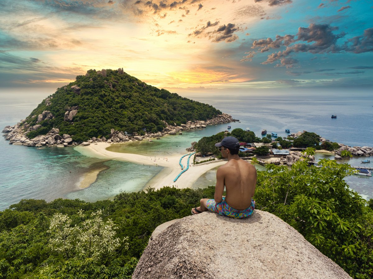
Koh Tao covers roughly 21 square kilometres of granite boulders, jungle ridges and coral bays in the Gulf of Thailand, about 45 kilometres north of Koh Phangan, and almost everything outdoors here comes back to the water. The island is one of the world's busiest places to earn a PADI dive certification; on a calm morning in Sairee you'll hear compressors humming before the first coffee. Inland, the terrain rises fast: concrete roads out of Mae Haad pitch up at gradients that make scooters whine, and the ridges above Tanote Bay smell of damp leaves and wood smoke after rain. At 18:00 on 27 September 2026 it was 26.4°C with light drizzle and 81% humidity, which is typical of the shoulder weeks before the northeast monsoon. There are no city parks in the usual sense; the green spaces are viewpoints, headlands and the three linked islets of Koh Nang Yuan. Solo travellers tend to feel at ease on the trails and beaches, and Koh Tao's solo-traveler safety score is 7.6/10 (see the TTDI Solo-Safety Index), though empty headland paths after dark are another matter.
Outdoor activities
-
Scuba diving courses and fun dives
The Open Water course takes 3 to 4 days, and schools cluster along Sairee Beach, Mae Haad and Chalok Baan Kao. Chumphon Pinnacle, northwest of the island, is a granite spire covered in anemones where whale sharks have been seen in some years, and Sail Rock, sitting between Koh Tao and Koh Phangan, has a vertical swim-through called the Chimney. Shallower training sites such as Twins and Japanese Gardens off Nang Yuan tend to have soft sand bottoms and plenty of butterflyfish. Prices currently vary between schools, so compare 3 or 4 before you book.
- Difficulty
- Beginner to advanced, depending on site and certification
- Duration
- Half-day fun dives; 3 to 4 days for Open Water
- Best season
- March to September for visibility; April and May are often the calmest
-
Freediving
Koh Tao has a cluster of freediving schools, with Apnea Total and Blue Immersion among the longer-established names. Level 1 courses tend to start in a pool or at a shallow sandy site before moving to deeper lines off the east coast, and the water is warm enough that many people train in a 3mm suit or a rash vest.
- Difficulty
- Beginner-friendly at entry level; physically demanding at depth
- Duration
- 2 to 3 days for an entry-level course
- Best season
- March to September, when the Gulf is flatter
-
Cliff jumping at Tanote Bay
Tanote Bay on the east coast has a large boulder that swimmers climb and jump from, roughly 5 to 6 metres above the water depending on the tide, and the rock is sharp and slick with algae near the waterline. Check the depth first, and skip it when swell is rolling in from the east. The road down to Tanote is steep and partly rough concrete.
- Difficulty
- Moderate; requires confident swimming
- Duration
- 1 to 2 hours including swimming
- Best season
- March to September; avoid November and December swells
-
Rock climbing and bouldering
The granite that shapes Koh Tao's coastline also gives the island a small climbing scene, with Goodtime Adventures running guided climbing and bouldering trips here for years. The rock is coarse, grippy and hot by midday. Climbing stays small next to diving, so book ahead rather than turning up at the crag.
- Difficulty
- Beginner to intermediate with a guide
- Duration
- Half day
- Best season
- January to April, when the rock is drier and the air a little cooler
-
Muay Thai training
Several gyms around Sairee and Mae Haad run morning and afternoon Muay Thai classes, with sessions that mix skipping, pad work and clinch drills in open-sided sheds that smell of liniment and sweat. It is a good wet-season option when the sea is too rough for boats.
- Difficulty
- All levels
- Duration
- About 90 minutes to 2 hours per class
- Best season
- Year-round
Day hikes
-
Sairee to Mango Viewpoint
The route starts in north Sairee and climbs steep concrete, then dirt track, into the jungle toward Mango Viewpoint, with some sections steep enough that you'll be using your hands on the rocks. After rain, the red clay turns greasy. Carry at least 1.5 litres of water, because shade is patchy on the lower road.
- Difficulty
- Moderate to strenuous
- Duration
- About 1 to 1.5 hours up from Sairee
- Best season
- January to April, after the northeast monsoon rains have ended
-
Freedom Beach and John-Suwan Viewpoint
From the Chalok Baan Kao end, a path threads through a resort area to Freedom Beach, then climbs over rocks and roots to the viewpoint, short in distance but steep, and the final boulders are polished smooth by foot traffic. Go early. By 10:00 the granite radiates heat like a skillet.
- Difficulty
- Easy to moderate
- Duration
- About 20 to 30 minutes each way from Chalok Baan Kao
- Best season
- February to September; morning is best year-round
-
Mae Haad south to Sai Nuan and June Juea
South of Mae Haad pier, a coastal path runs over headlands to the quiet bays of Sai Nuan and June Juea, though parts of it are uneven rock and exposed roots, and a few sections pass behind small bungalow resorts. The water at Sai Nuan is clear and good for a mid-hike snorkel.
- Difficulty
- Moderate
- Duration
- About 45 minutes to 1 hour one way from Mae Haad
- Best season
- March to September, when the paths are drier
-
Inland ridge walk to Tanote Bay
From the Mae Haad side, the concrete road climbs east over the island's central ridge and then drops steeply to Tanote Bay, and walking it takes effort. Scooters tend to struggle on the descent, which is part of why walking is a reasonable option here. Expect coconut and cashew trees and a view down to the bay near the end.
- Difficulty
- Moderate, with steep sustained gradients
- Duration
- About 1 to 1.5 hours one way
- Best season
- January to August
Water activities
-
Snorkelling at Shark Bay (Ao Thian Ok)
Shark Bay on the southeast coast is known for blacktip reef sharks, usually small and shy, in the shallows, and hawksbill or green turtles turn up fairly often. The bay tends to be calmest in the morning. Don't stand on coral, and keep your fins off the reef flats at low tide.
- Difficulty
- Easy to moderate
- Duration
- 1 to 2 hours
- Best season
- March to September; early morning for shark sightings
-
Kayaking from Sairee to Koh Nang Yuan
Kayak rentals are common along Sairee Beach, and a few paddlers cross to Nang Yuan in calm weather, though the crossing is open water with longtail and dive-boat traffic, so stay well clear of the boat lanes. Afternoon wind from the west can build chop fast. Pay the landing fee when you arrive.
- Difficulty
- Moderate; open-water crossing
- Duration
- Half day including time on the island
- Best season
- March to May, when mornings are glassy
-
Snorkelling at Aow Leuk and Tanote Bay
Aow Leuk, on the southeast side, has a sandy entry and reef along both edges that suits beginners, while Tanote Bay is rockier, with parrotfish grazing on boulders in 2 to 4 metres of water. Both roads in are steep, so a taxi might be the smarter call than a rented scooter.
- Difficulty
- Easy
- Duration
- 2 to 3 hours
- Best season
- March to September
-
Swimming and sunset at Sairee Beach
Sairee is the island's longest beach, about 1.7 kilometres of sand on the west coast. The water is shallow and warm, around 29°C in the dry months, and tends to be calm when the east coast is choppy. It gets busy with dive boats at the moorings, so swim inside the buoys.
- Difficulty
- Easy
- Duration
- As long as you like
- Best season
- Year-round; best March to October
Parks & gardens
-
Koh Nang Yuan
Three small islands joined by a sandbar, about 10 minutes by longtail from Sairee's northern end. The sand spit is the famous view, and the islands are privately operated, charging a landing fee (around 100 THB, roughly 3 USD, in recent years) with a ban on plastic bottles, so decant your water before you land.
Highlights: The sandbar walk at low tide, the wooden stair-and-boardwalk climb to the summit viewpoint, and the Japanese Gardens reef off the eastern shore.
-
John-Suwan Viewpoint
A granite outcrop on the headland between Chalok Baan Kao and Shark Bay, reached through Freedom Beach, where a small entry fee has been collected at the trailhead in the past. From the top you look down both bays at once, and the rock can be scorching after 11:00.
Highlights: The twin-bay view over Chalok Baan Kao and Shark Bay, and the boulder scramble near the summit.
-
Mango Viewpoint
A high lookout above Mango Bay (Ao Mamuang) in the north of the island, reached by steep road and track from the Sairee side. The forest up here is dense and loud with cicadas in the afternoon, and access is sometimes through private land with a small fee.
Highlights: Views north over Mango Bay and west toward Koh Nang Yuan; sunset light over the Gulf.
Practical tips
- Sun and heat
- The UV index on Koh Tao climbs fast from late morning, and light cloud doesn't offer much protection. Pack a reef-safe sunscreen and a long-sleeve rash vest for snorkelling, and plan any hikes before 10:00 or after 16:00.
- Water and hydration
- Carry 1.5 to 2 litres per person on any inland hike. Many cafes and dive shops in Sairee and Mae Haad have refill stations, and topping up there is worth forming a habit, since Nang Yuan operates a plastic-bottle ban.
- Footwear and trail conditions
- Wear trail shoes or sturdy sandals with grip, because Koh Tao's granite is slick when wet and clay tracks on the ridges turn to grease within minutes of rain. Flip-flops cause a lot of the minor injuries seen at the island's clinics.
- Scooters and steep roads
- The roads to Tanote, Aow Leuk and Mango Bay are steep, narrow and sometimes sandy. Scooter gravel rash is common enough on Koh Tao that locals joke about it, so if you haven't ridden steep hills before, take a pickup taxi from Mae Haad instead.
- Monsoon timing
- The Gulf's northeast monsoon usually brings the heaviest rain and roughest east-coast seas from late October to December. Boats still run most days, but some dive sites close and ferries can be cancelled, so build in a spare day before any onward flight.
- Marine etiquette
- Don't touch or feed marine life at Shark Bay or Nang Yuan, and keep a few metres from turtles. Some operators contribute to local reef-restoration projects, and it's reasonable to ask about that when you book.
FAQ
When is the best time for outdoor activities on Koh Tao?
March to September generally brings the calmest seas and best visibility. April and May tend to be the hottest and flattest months of that window, while late October to December is the rainy stretch, when trails get muddy and east-coast bays are often rough.
Do I need a permit to hike on Koh Tao?
No general hiking permit is required. Some viewpoints, including John-Suwan and Mango, sit on private land and may collect a small entry fee at the trailhead, and Koh Nang Yuan charges its own landing fee.
Can beginners snorkel without a boat tour?
Yes. Aow Leuk, Sai Nuan and the shallows at Shark Bay are all reachable from shore, but check the wind direction first: the east coast gets choppy when wind blows from the northeast.
Is it safe to walk trails alone on Koh Tao?
Daytime hikes on the main routes are generally fine alone: tell your guesthouse where you're going, carry a charged phone, and avoid the headland paths after dark, when roots and rocks are hard to see.
Where can I find more travel basics for Koh Tao?
Wikivoyage's Koh Tao article covers ferries from Chumphon and Koh Samui, getting around the island, and safety notes; the Get in and Stay safe sections are the most useful to read before you arrive.
Last verified by automated review (v1.7.2) on . What is automated review?