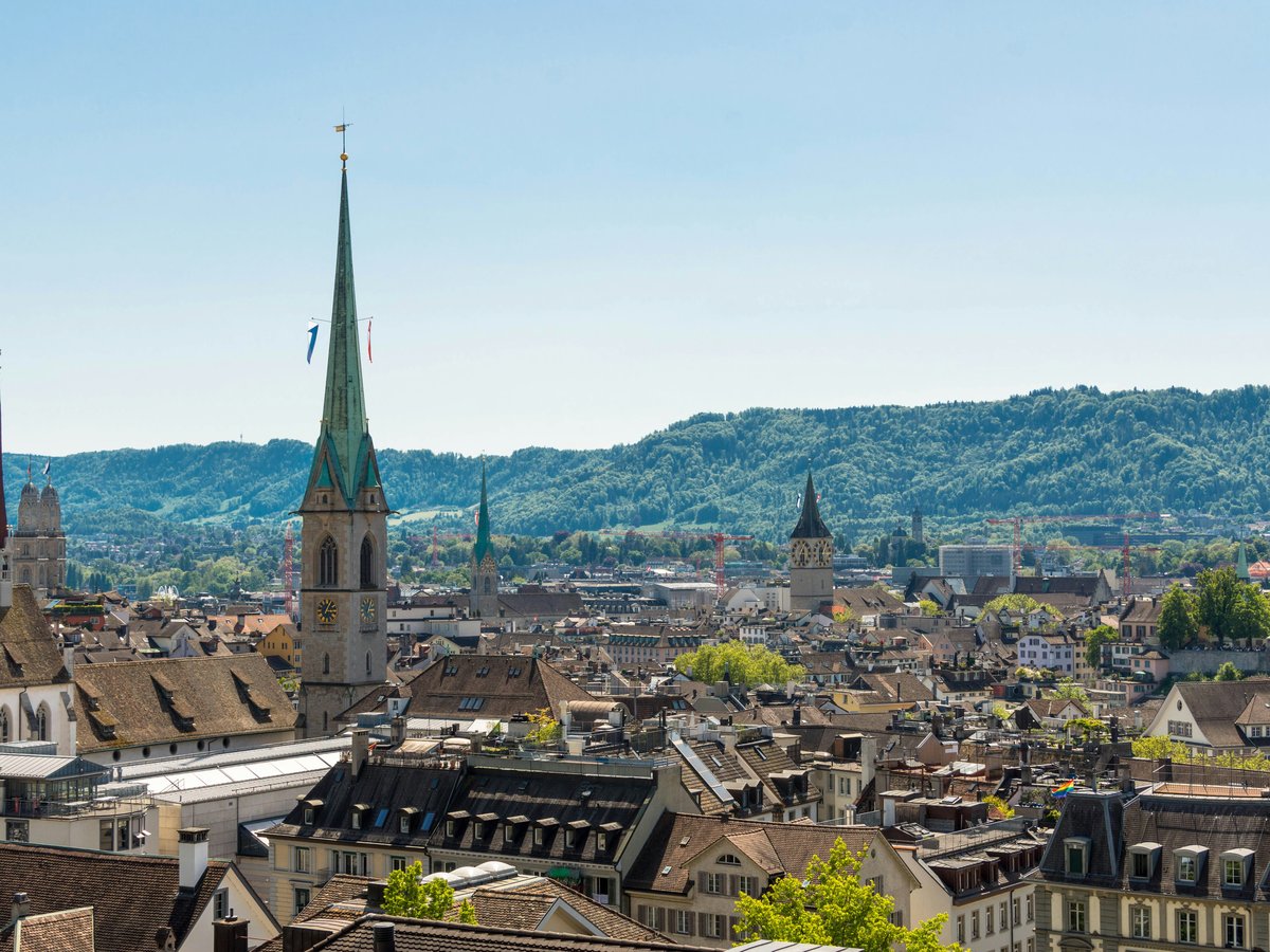
Zurich sits at the northwest end of its namesake lake, where the Limmat River begins flowing north toward the Aare. The Uetliberg ridge runs along the city's western edge and tops out at 871 meters. To the east, the Zürichberg climbs through dense beech and oak forest toward the neighborhoods of Fluntern and Witikon. Between these two ridges the city fits into a natural corridor roughly 5 kilometers wide, with the Sihl River joining the Limmat near the Hauptbahnhof. On days when the Föhn wind pushes south, the Glarner Alps appear on the horizon about 60 kilometers away. More than 50 public bathing spots, locally called Badis, line the lakefront and both rivers. Locals in Kreis 5 swim the Limmat on their lunch breaks through July and August, and the smell of charcoal smoke drifts from every park by late afternoon. Zurich scores 8.8 out of 10 for solo-traveler safety (see the TTDI Solo-Safety Index), which makes exploring trails and lakeside paths alone comfortable well into the evening. Yellow signs mark walking routes across the surrounding hills, red-and-white blazes cover mountain paths, and intersection signposts show distances in hours and minutes to the next named destination. A ZVV day pass covers every S-Bahn, tram, and bus in the network, so reaching trailheads rarely takes more than 20 minutes from the city center.
Outdoor activities
-
Cycling the Lake Zurich Loop
The full circuit around Zürichsee follows a mix of dedicated bike lanes and quiet lakeside roads for roughly 50 kilometers. The eastern shore through Meilen and Stäfa tends to carry less motor traffic than the western side through Thalwil. You'll pass vineyards above Männedorf and small harbors where wooden fishing boats knock against their moorings. Elevation gain is minimal. Bike rentals are available at Zürich HB through PubliBike stations or several private shops in Kreis 1.
- Difficulty
- Easy to moderate (flat with minor rollers)
- Duration
- 3-5 hours depending on pace and stops
- Best season
- May through October
-
Trail Running on Zürichberg
The forested ridge east of the city center has soft-surface trails through beech canopy that stays cool even when the valley floor hits 30 degrees. The air smells like damp earth and leaf litter after rain. Paths near Zoo Zürich connect into loops of 5 to 15 kilometers without repeating much ground. The tram 6 terminus at Zoo is a good entry point. Some sections can be slippery after wet weather, particularly the steeper cuts toward Witikon.
- Difficulty
- Easy to moderate (rooted, uneven sections in places)
- Duration
- 45 minutes to 2.5 hours
- Best season
- April through November
-
Mountain Biking on Uetliberg
Several marked mountain bike trails descend from the Uetliberg summit area toward Adliswil and Uitikon. The descent to Adliswil drops about 500 meters over roughly 4 kilometers of forest singletrack, with loose rock in the steeper sections. Most riders take the S10 train up and ride down, which keeps the effort fun rather than grinding. The trails see heavy foot traffic on weekends, so Tuesday and Wednesday afternoons tend to be quieter.
- Difficulty
- Moderate to difficult (technical descents, loose surface)
- Duration
- 1-2 hours including the train up
- Best season
- May through October
-
Vitaparcours Fitness Trails
Switzerland's national network of Vitaparcours runs through forests in nearly every municipality, and Zurich has several within city limits. The Zürichberg course winds through the forest with wooden exercise stations every few hundred meters for pull-ups, balance work, and stretching. Free, no registration. The bark-chip surface is forgiving on joints. You'll share the path with dog walkers and joggers, and the canopy keeps it shaded through the summer months.
- Difficulty
- Easy (self-paced, adjustable at each station)
- Duration
- 30-60 minutes per circuit
- Best season
- Year-round (muddy patches after heavy rain)
-
Inline Skating on the Lake Promenades
The paved promenades along both shores of Lake Zurich from Bürkliplatz toward Tiefenbrunnen on the east side and Wollishofen on the west are smooth enough for inline skating. The eastern stretch runs about 3 kilometers along the Seefeld district with views across the water toward the Enge shoreline. Friday evenings in summer bring a casual skate meetup that loops through the city center. Skate rentals are available at a few sports shops near Bellevue.
- Difficulty
- Easy (flat, paved)
- Duration
- 1-2 hours
- Best season
- April through October
Day hikes
-
Uetliberg to Felsenegg Ridge Walk (Planetenweg)
The signature day hike from Zurich. Take the S10 from Hauptbahnhof to the summit station, then follow the ridge south toward Felsenegg along the Planetenweg, a trail marked with scale-model planets representing the solar system. The path rolls gently along the ridgeline through mixed forest and open meadow, with views east across the lake and south toward the Albis chain. At Felsenegg, the Luftseilbahn Adliswil-Felsenegg cable car drops you to Adliswil in 5 minutes, and the S4 returns you to the city. Trail surface is gravel and packed earth, well maintained and clearly signed throughout.
- Difficulty
- Easy (minor elevation changes, well-graded path)
- Duration
- About 2 hours one way, 6 km
- Best season
- Year-round (icy patches possible December through February)
-
Pfannenstiel from Forch
Take the Forchbahn from Stadelhofen to Forch, then walk southeast through farmland and patches of forest to the Pfannenstiel summit at 853 meters. The route passes small farms where you might hear cowbells in the pastures, and the views from the top stretch west across the full length of Lake Zurich. You can extend the hike by descending east toward Greifensee for a different return route via S-Bahn. Trail marking is the standard yellow-sign Wanderweg system.
- Difficulty
- Moderate (steady climb of about 300 meters, some exposed sections)
- Duration
- 3-4 hours round trip, about 10 km loop
- Best season
- April through November
-
Greifensee Circular Trail
A flat lakeside walk around the smaller Greifensee, about 25 minutes east of Zurich by S-Bahn. The trail circles the lake through reed beds, orchards, and the medieval village of Greifensee with its 14th-century castle tower. Birdwatchers come for the wetland reserve on the southern shore, where herons and lapwings nest. The full circuit covers roughly 20 km, but you can shorten it by catching a bus from several stops along the route. Flat gravel paths the whole way.
- Difficulty
- Easy (flat, no technical terrain)
- Duration
- 5-6 hours for the full loop, or 2-3 hours for a half circuit
- Best season
- March through November
-
Sihlwald Forest Reserve
The Sihlwald is one of the few designated natural forest reserves in the Swiss Mittelland, where fallen trees are left to decompose and the canopy grows untended. Take the S4 to Sihlwald station and follow marked trails into the forest. The air in here is noticeably cooler and damper than the surrounding farmland, and the quiet is striking for a place 20 minutes from a major city. A visitor center near the station has maps and information about the re-wilding program. Several loop options of 3 to 8 km are possible.
- Difficulty
- Easy (mostly flat forest paths with some roots and mud)
- Duration
- 1.5-3 hours depending on loop choice
- Best season
- Year-round (autumn colors peak in late October)
-
Hörnli from Steg im Tösstal
A proper hill walk in the Zürcher Oberland, the rural northeast of the canton. Take the S-Bahn to Steg im Tösstal and climb through forest and alpine pasture to the Hörnli summit at 1,133 meters, the highest point in Canton Zurich. The views from the top take in the Säntis massif to the east and, on Föhn days, a long stretch of the Bernese Oberland to the southwest. A restaurant operates at the summit from spring through autumn. You can vary the descent route for a different return loop.
- Difficulty
- Moderate to challenging (600+ meters elevation gain, steep sections near the top)
- Duration
- 4-5 hours round trip, about 12 km
- Best season
- May through October
Water activities
-
River Swimming at Oberer Letten
The Oberer Letten Badi in Kreis 5 is Zurich's most popular free river swimming spot. The Limmat current here is gentle but steady, carrying swimmers downstream at a walking pace. Entry is free and there is no formal closing time, though lifeguards operate roughly 9:00 to 19:00 from mid-May through mid-September. The concrete banks get warm in the afternoon sun, and the adjacent bar sells drinks and snacks. Water temperature reaches about 20-22 degrees Celsius in July and August.
- Difficulty
- Easy (calm current, shallow entry points)
- Duration
- As long as you like
- Best season
- Mid-May through mid-September
-
Lake Swimming at Seebad Enge and Utoquai
Lake Zurich has half a dozen formal Badis with changing rooms, diving platforms, and food service. Seebad Enge sits on the western shore with views toward Zürichhorn, while Utoquai on the eastern shore faces west and catches the afternoon sun. Entry to most lake Badis runs 6 to 8 CHF. The lake water is clean and stays cool even in August, typically 18-22 degrees at the surface. Mind you, the diving towers attract a crowd on hot weekends, so early mornings are calmer.
- Difficulty
- Easy (sheltered, lifeguard-monitored areas)
- Duration
- 1-4 hours
- Best season
- June through September
-
Kayaking on Lake Zurich
Several rental outfits near Zürichhorn and Strandbad Mythenquai rent sit-on-top and touring kayaks by the hour. The route south from the city toward Thalwil or Küsnacht sees less boat traffic than the inner harbor. The lake stretches about 28 kilometers from Zurich to Rapperswil, a full day in a touring kayak if you are ambitious. Afternoon westerly winds can build chop on the open water, so morning departures tend to be calmer. Expect to pay 30-40 CHF per hour for a single kayak.
- Difficulty
- Easy to moderate (lake conditions vary with wind)
- Duration
- 1-6 hours
- Best season
- May through September
-
Stand-Up Paddleboarding
SUP rental stations have appeared at several points along the Zurich lakeshore over the past few years, with boards typically available at Zürichhorn and Mythenquai from May onward. The inner basin near Bürkliplatz is sheltered and good for beginners, though boat traffic picks up after 10:00. Rental rates run 25-35 CHF per hour. The lake surface tends to be glassy before 9:00 in the morning, which is when experienced paddlers head out. A life vest is included with most rentals.
- Difficulty
- Easy (flat water in sheltered areas)
- Duration
- 1-2 hours
- Best season
- May through September
-
ZSG Lake Zurich Boat Cruise
The Zürichsee-Schifffahrtsgesellschaft operates regular passenger boats from Bürkliplatz the full length of the lake to Rapperswil, with stops at towns along both shores. The full trip takes roughly 2 hours each way. You can bring a bicycle on board for a small surcharge and ride one direction while cruising the other. GA and ZVV zone passes cover certain routes. The upper deck on a clear day gives you a slowly shifting view of the pre-Alpine foothills reflected in the water.
- Difficulty
- None (passenger boat)
- Duration
- 2 hours one way to Rapperswil, or 1-hour short cruises
- Best season
- April through October (reduced winter schedule)
Parks & gardens
-
Rieterpark
FreeA hillside park in the Enge district that slopes down from a cluster of 19th-century villas toward the lake. The grounds house Museum Rietberg, founded in 1952 in the Villa Wesendonck, where Richard Wagner once visited regularly. Tall cedars and copper beeches shade the lawns, and the western-facing slope catches late afternoon sun that warms the grass well into October. On clear days you can see past the rooftops toward the water.
Highlights: Villa Wesendonck, mature specimen trees including Lebanese cedars, panoramic benches on the upper lawn, free park entry with museum admission separate
-
Chinagarten (Chinese Garden)
A compact classical Chinese garden at Zürichhorn on the eastern lakeshore. It was built in the early 1990s as a gift from Kunming, Zurich's partner city in Yunnan province. The layout follows traditional Chinese garden design, fitting a pavilion, a zigzag bridge, a koi pond, and carefully placed rockwork into roughly 3,500 square meters. The sound of water moving through stone channels follows you around every corner. A small entry fee applies.
Highlights: Lakeside pavilion with carved wooden screens, Moon Gate entrance, lotus pond, bamboo groves
-
Irchelpark
FreeA large park in Zürich Nord adjacent to the University of Zurich Irchel campus. The park was constructed on a former landfill in the 1980s. It has matured into a landscape of rolling meadows, wooded patches, and a central pond where ducks nest in spring. The open lawns fill with students and families on warm afternoons, and the park's size means it rarely feels crowded even on peak weekends.
Highlights: Central pond with reed beds, open meadow for picnics and sports, wooded walking loops, botanical plantings near the university
-
Lindenhof
FreeA small elevated square on the western bank of the Limmat, shaded by old linden trees. The site has been occupied since Roman times, and stone remnants of a 4th-century fortress lie beneath the gravel. From the railing you look directly across the river at the twin towers of the Grossmünster, a church whose construction finished in 1201, and downstream toward the Fraumünster spire. Locals play chess on the permanent outdoor boards here, and the morning light filters through the leaves in a way that warms the whole square even in early spring.
Highlights: Roman-era historical layers, outdoor chess boards, unobstructed old-town views, quiet benches under the linden canopy
-
Platzspitzpark
FreeThe park sits at the point where the Limmat and Sihl rivers meet, directly behind the National Museum Zurich, a building that opened in 1898 and still dominates the northern edge with its turreted facade. The grounds were redesigned in the 1990s and currently serve as a calm green strip popular with office workers from the nearby Europaallee district. Old plane trees line the gravel paths, and the sound of both rivers is audible from most benches.
Highlights: River confluence viewpoint, proximity to the National Museum garden cafe, mature plane tree allée, useful midday rest stop between Hauptbahnhof and Niederdorf
-
Belvoirpark
FreeA sloping park in the Enge quarter with a neoclassical villa at its center and views down to the western lakeshore through gaps in the tree line. The grounds were donated to the city in 1890 and retain a 19th-century feel with gravel walking paths, ornamental plantings, and a small pond. A restaurant operates from the villa during warmer months. The park lies between the Enge S-Bahn station and the lake, which makes it a natural pause on the walk toward the western shore Badis.
Highlights: Neoclassical villa and seasonal restaurant, ornamental gardens, quieter atmosphere compared to busier lakefront parks, views toward the Mythenquai shore
Practical tips
- Gear and Layering
- Zurich's weather shifts quickly, even in summer. A lightweight rain shell fits into any daypack and earns its weight by mid-afternoon when clouds build over the Albis ridge. For the trails on Zürichberg and around the lake, trail running shoes with moderate grip handle everything except the steepest descents in wet conditions. Dedicated hiking boots are only necessary for the Hörnli or full-day ridge walks. Cotton holds moisture in the 60-70 percent summer humidity typical of this region, so synthetic or merino base layers work better for any outing over an hour.
- Sun Protection
- The UV index in Zurich reaches 7-8 in July and August, roughly comparable to the Mediterranean coast. The altitude on the summits above the city adds intensity beyond what you feel at lake level. Sunscreen rated SPF 30 or higher, sunglasses, and a cap are standard for any day on the water or above the tree line. The lake surface reflects strongly, which compounds exposure during SUP and kayak outings.
- Drinking Water
- Zurich's tap water comes from the lake and from springs, filtered and treated to a high standard. Over 1,200 public fountains across the city run continuously with potable water unless marked Kein Trinkwasser. Fill a reusable bottle at any of them. On trail, the fountains become less frequent above Adliswil and in the Sihlwald, so carry at least a liter for hikes longer than 2 hours.
- Trail Conditions and Markings
- Swiss trail markings follow a national system. Yellow diamonds or arrows mark Wanderwege, walking paths that are generally well-graded and family-friendly. White-red-white markers indicate Bergwege, mountain paths that may include exposed or rocky sections. All the hikes in this guide follow Wanderwege except the Hörnli summit approach, which has a short Bergweg section near the top. After rain, the clay-heavy soils on the Zürichberg can be slick for a day or two.
- Currency and Costs
- Switzerland uses the Swiss franc. As of August 2026, 1 USD buys about 0.80 CHF, so prices in francs are roughly 25 percent higher than the number suggests in dollars. A Badi entry runs 6-8 CHF, a SUP rental 25-35 CHF per hour, and a ZVV day pass for the core zones costs roughly 13-14 CHF for adults. Credit cards work almost everywhere, though some Badis and smaller kiosks still prefer cash or Twint, the Swiss mobile payment app.
- Getting to Trailheads
- Every hike and outdoor destination in this guide is reachable by ZVV public transport from Zürich Hauptbahnhof in 30 minutes or less, except the Hörnli, which takes about 50 minutes by S-Bahn. The ZVV app shows real-time connections and sells mobile tickets. Zurich scores 9.2 out of 10 for family friendliness (see the TTDI Family-Friendliness Index), and the public-transport accessibility is a big part of that. Strollers and bikes ride on all S-Bahn trains outside peak commuter windows.
FAQ
Is it safe to swim in the Limmat and Lake Zurich?
Both the Limmat and Lake Zurich are monitored for water quality and considered safe for swimming during the Badi season from mid-May through mid-September. The city publishes water-quality reports regularly. At Oberer Letten, the current is mild but steady, so enter and exit at designated points and avoid the weir downstream. Lake Badis have lifeguards during posted hours. Children should stick to the roped-off areas, as depth increases quickly beyond the platforms.
How do I get to Uetliberg from the city center?
The S10 train runs from Zürich Hauptbahnhof to the summit station every 30 minutes, and the ride takes about 20 minutes. A standard ZVV zone ticket covers the trip. The summit area has a lookout tower, a restaurant, and the start of the ridge trail toward Felsenegg described earlier in this guide. You can also walk up from the Triemli tram stop (tram 9) in about 90 minutes, which adds roughly 400 meters of elevation gain through forest.
What is the best time of year for outdoor activities in Zurich?
Late May through September covers the widest range, with lake and river swimming, hiking, and cycling all in full season. June tends to be wet, so prepare for afternoon thunderstorms. July and August are warmest, with temperatures typically around 24-28 degrees Celsius at lake level. September and October bring stable weather and autumn color, especially in the Sihlwald. Winter limits options to walking and short trail runs, though mild conditions have been increasingly common in recent years.
Do I need hiking boots for walks around Zurich?
For the ridge walk from the summit to Felsenegg, the Greifensee loop, and the Zürichberg forest trails, sturdy trail shoes or sneakers with reasonable grip are fine. The paths are gravel or packed earth. For the Hörnli and any extension into steeper Bergweg-marked terrain, ankle-supporting hiking shoes are a better choice, especially if the ground is wet. Flip-flops work at the Badis but not on any trail.
Is Zurich welcoming for LGBTQ+ travelers doing outdoor activities?
Zurich scores 8.5 out of 10 on LGBTQ+ friendliness (sourced from TTDI's editorial rubric). The Badis, parks, and trails are public spaces used by everyone, and the city's culture around outdoor recreation is relaxed and inclusive. The Frauenbadi at Stadthausquai operates as a women-only bathing space during the day and opens to everyone in the evenings as the Barfussbar, a well-known summer hangout for a mixed crowd.
Can I rent outdoor gear in Zurich if I am traveling light?
Bike rentals are available through PubliBike stations around the city and through the free city bike-lending scheme at Hauptbahnhof. SUP and kayak rentals operate seasonally at several lakeside locations. For hiking poles, rain shells, and packs, Transa on Europaallee is a large outdoor retailer a 5-minute walk from Hauptbahnhof, with both purchase and rental options. Bächli Bergsport in the Seefeld area is another well-stocked alternative.
Last verified by automated review (v1.7.2) on . What is automated review?