How do I get around Medellin?
Metro Line A runs north-south through Medellín's valley for around 3,050 COP per ride. Load a Cívica card at any station. Uber and InDriver cover the gaps at 8,000-15,000 COP across town. Metrocable gondolas reach hillside comunas no bus handles well. Taxis are metered but drivers near tourist areas sometimes claim broken meters. Use the Tappsi app or Uber instead.
Book the connection
One search across trains, buses & flights — live times and prices for Medellin.
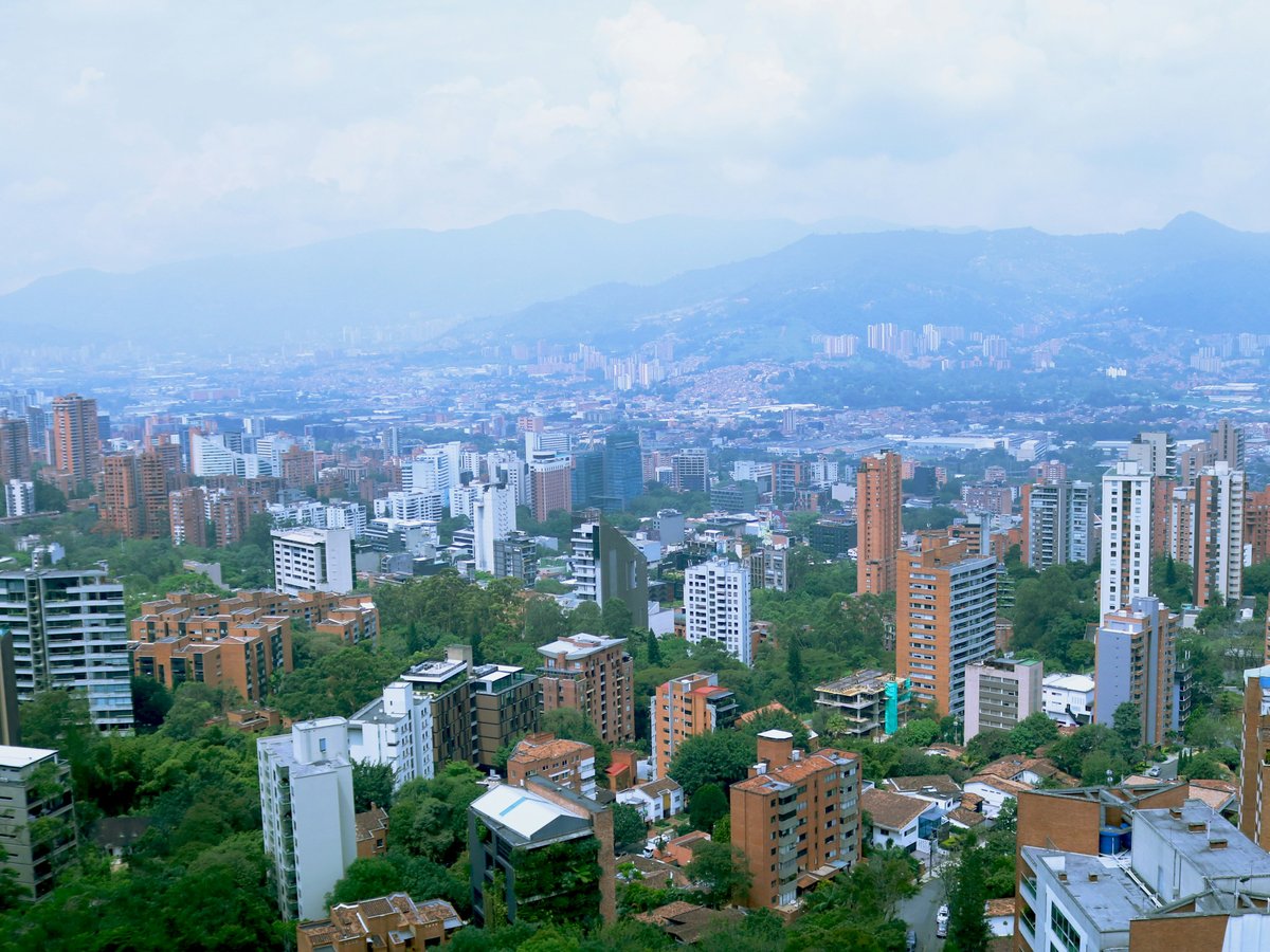
Medellín's Metro is Colombia's only rail transit system, and it tends to be the most reliable way to move through the city. Line A runs north-south through the Valle de Aburrá from Niquía to La Estrella, 25 stations over roughly 25 km. Line B branches west from San Antonio station to San Javier. A single ride costs around 3,050 COP, less than a dollar. The Cívica card, available at any station kiosk for about 5,000 COP, scans on every metro train, cable car, tram, and Metroplus bus in the network. Trains run every 3-5 minutes at peak hours, 6-10 minutes off-peak, from about 4:30 AM to 11 PM. San Antonio is the transfer hub where Line A, Line B, and the Tranvía tram all connect. If you're staying in El Poblado, Poblado station puts you directly on Line A with no transfer needed.
The Metrocable gondola lines are the part of the transit network that no other city in the Americas has matched at this scale. Line K climbs from Acevedo station to Santo Domingo Savio, the hillside neighborhood where the Spain Library (opened in 2007) sits with views across the entire valley. Line J runs from San Javier to La Aurora. Line P continues from Line K up to Parque Arví, a 16,000-hectare nature reserve at 2,600 meters elevation, where the temperature drops 5-6°C and the air smells like wet eucalyptus and pine. The Tranvía tram, Line T-A, runs east from San Antonio through Buenos Aires and Alejandro Echavarría. All of these modes use the same Cívica card. A single fare transfers across any combination of metro, cable, and tram within about 95 minutes.
For anything the metro doesn't reach, Uber and InDriver both operate in Medellín, though neither is fully legal. Drivers use them anyway, and they work well. Expect 8,000-15,000 COP for most cross-city trips. El Poblado to Laureles runs about 12,000 COP, roughly $3. InDriver lets you name your own price, which sometimes undercuts Uber by 20-30%. Yellow taxis are metered, starting at around 5,200 COP with increments of roughly 100 COP per 80 meters. The honest ones are fine. The problem is drivers around Parque Lleras and other tourist-heavy spots who claim the meter is broken or quote a flat fare at 3x the metered rate. Open the Tappsi app, which dispatches metered yellow cabs with the fare tracked digitally, or stick with Uber where the price is set before you get in.
Walking depends on the neighborhood and your tolerance for hills. Laureles is flat, grid-planned, and the most pleasant part of the city on foot. The sidewalks along Carrera 70 are wide, shaded by mango trees, and at 7 AM the smell of pan de bono drifts out from the bakeries. El Poblado, where most first-time visitors end up staying, is steeper than it looks on a map. The walk from Parque Lleras up to Provenza takes about 15 minutes uphill in 26°C heat and 80% humidity. It feels longer. Centro around Botero Plaza and the Museum of Antioquia (founded 1881) is flat but loud, with bus horns and vendors at full volume from 8 AM until dark. Worth the noise, though. The Coltejer Building, completed in 1972 and shaped like a sewing needle at 175 meters, is the easiest landmark for orienting yourself when you come out of a side street.
Buses cover every neighborhood, but the route system is opaque even for residents of 20 years. Destination signs on the windshield assume you already know the geography, and there's no reliable English-language route map. Stick to the Metro and ridehail apps for your first few days. Worth noting that Google Maps transit directions work for metro and Metroplus routes but sometimes suggest bus connections that haven't run in months. Moovit tends to be more current for bus routing. Download your offline maps before you arrive. Cell signal drops inside the metro tunnels between Cisneros and Industriales stations, and the free Wi-Fi at metro stations is unreliable at best.
On-the-ground: metro available · ride-hail apps work.
Primary modes of transit
- Metro
- Metrocable
- Uber/InDriver
- Taxi
- Tranvía
- Walking
Ready to book the connection?
See Medellin flights on Omio — live times & prices in one search.
Compare on Omio →More transport questions
How do I get from the airport to Medellin?
From José María Córdova Airport (MDE), take a colectivo shared minivan to the San Diego mall terminal in El Poblado for about 18,000 COP ($4.50), roughly 45 minutes via the Túnel de Oriente. Official taxis run a flat 95,000-120,000 COP ($23-29). Uber and InDriver work but pickup can be inconsistent.
Full answerHow do I get to Medellin?
José María Córdova International Airport (MDE) in Rionegro, 29 km east of Medellín, handles all international flights. Nonstop service from Miami, Fort Lauderdale, New York JFK, Houston, and Atlanta runs on Avianca, American, JetBlue, Spirit, and United. Round-trip fares from the US run $300 to $650. No European nonstops exist. Connect via Bogotá on Avianca or Panama City on Copa Airlines.
Full answerWhat are the best day trips from Medellin?
Guatapé is the top pick, 80 km east by 15,000-COP bus from Terminal del Norte, with the 740-step Piedra del Peñol and a colorful lakeside town that works even if one partner skips the climb. Santa Fe de Antioquia, 80 km northwest, has 32°C heat and a compact colonial center. Parque Arví is the easiest option, reachable by Metrocable from central Medellín in 50 minutes.
Full answerLast verified by automated review (v1.7.2) on . What is automated review?