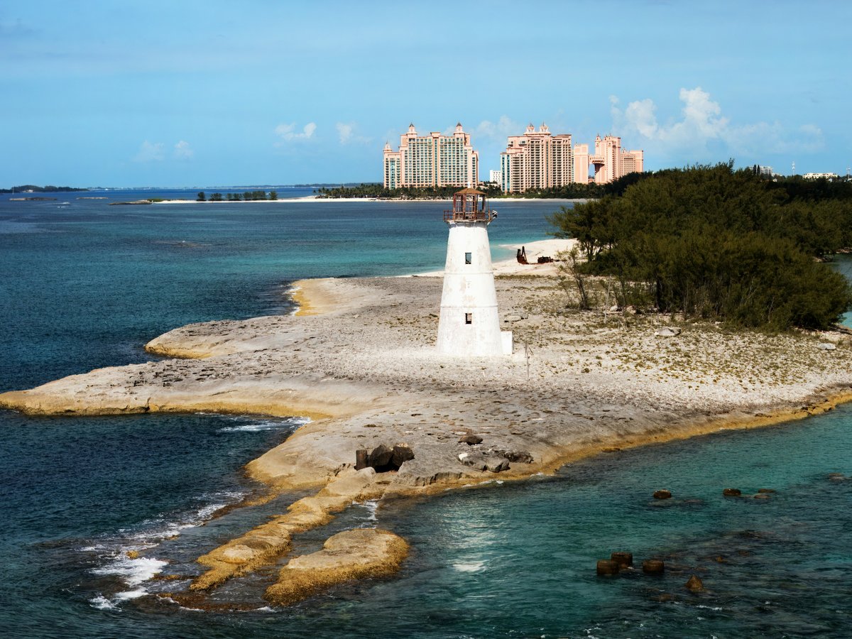
Nassau is the capital of The Bahamas, with roughly 275,000 people spread across New Providence, an island about 21 miles long and 7 miles wide. A limestone ridge runs east to west through the city's center and serves as the old dividing line. North of it you'll find the waterfront, the cruise terminal at Prince George Wharf, and the colonial commercial district along Bay Street. South of the ridge, locals call the residential quarters 'Over-the-Hill.' Cable Beach, the main resort strip, lies about 5 miles west of downtown along West Bay Street. Paradise Island sits directly across Nassau Harbour, connected by two road bridges. Early September mornings start around 25°C but feel closer to 30°C when the humidity (currently around 86%) hits. The Bahamian dollar is pegged 1-to-1 with the US dollar, and most businesses on the island accept either currency. Downtown's walkable core covers about a mile, but getting between districts usually means a jitney ride or a taxi.
Neighborhoods
-
Downtown Nassau & Bay Street
This is the oldest part of the city, built on a slope that climbs south from the harbour toward the ridge. The buildings along Bay Street mix Georgian-colonial stone facades with 1960s-era commercial blocks, most of them painted in sun-faded pinks, yellows, and whites. Christ Church Cathedral has held its spot on George Street since 1670. St. Francis Xavier Cathedral on West Street dates to 1886. The pace depends entirely on the cruise schedule. When 3 or 4 ships dock at Prince George Wharf on a Tuesday morning, Bay Street floods with foot traffic from Rawson Square to the Straw Market. On ship-free days, the same stretch feels nearly empty. You'll hear gospel music drifting from open church doors on Sundays. The smell of conch fritters from vendors near Woodes Rogers Walk carries on the salt breeze most afternoons.
- Best for
- First-time visitors, history-focused travelers, and anyone who wants walkable access to Nassau's colonial-era landmarks without relying on taxis
- Key streets
- Bay Street runs parallel to the waterfront for about a mile and serves as the main commercial artery. Parliament Street climbs south from Rawson Square to Parliament Square, where the pink-columned Senate building sits. Elizabeth Avenue continues uphill toward the Queen's Staircase, 65 steps carved from solid limestone by enslaved people in the late 1700s. George Street, one block south of Bay, tends to be quieter and has a few Bahamian lunch spots serving cracked conch and peas 'n' rice for $10-14.
-
Over-the-Hill (Grants Town & Bain Town)
South of the ridge, the streets narrow and the tourist infrastructure disappears. Grants Town and Bain Town are working-class residential neighborhoods that predate much of Bay Street's current architecture. Small wooden houses line the roads, many with traditional Bahamian shutters and front porches close enough to the sidewalk that you'll overhear conversations from 10 feet away. The smell of stew fish and peas 'n' rice drifts from home kitchens and small restaurants that might seat 8 people. On weekends, sound-system bass from a house party on Augusta Street carries two blocks over. There is no pretense here. That is the appeal.
- Best for
- Travelers comfortable navigating unfamiliar neighborhoods who want to eat where locals eat. Worth noting, this is the area where caution matters most after dark, so plan to visit during daylight hours.
- Key streets
- Market Street and Meeting Street are the main north-south routes climbing over the ridge from downtown. Blue Hill Road runs parallel further west and has the densest cluster of local food stalls. Augusta Street near the Grants Town boundary has a few older churches worth a look.
-
Cable Beach
West Bay Street runs past Goodman's Bay Park and then hugs a 2-mile crescent of pale sand. The Baha Mar complex dominates the western end with three hotel towers and a casino that opened in stages starting in 2017. The beach itself is public, and locals still use the eastern stretch near Goodman's Bay on weekends for cookouts and pickup soccer. The water here tends to be calmer than the harbour side, with a gradual sandy bottom that drops off slowly. The pace is resort-slow. You'll hear pool DJs from the Baha Mar deck during the afternoon, and the warm chlorine-and-salt air hits you at the property line. Between the resorts, the food options along West Bay Street are sparse, but a few Bahamian fish fry spots operate from converted houses.
- Best for
- Families who want beach time and pool access without the intensity of downtown. Nassau scores 6.8/10 for family friendliness (see the TTDI Family-Friendliness Index), and this stretch is where that rating holds up best.
- Key streets
- West Bay Street is the only real through-road, running between the beach and the low limestone hills inland. Goodman's Bay Park at the eastern end has free parking and picnic tables. The walk along the sand from Goodman's Bay to the Baha Mar entrance takes about 25 minutes.
-
Paradise Island
Two bridges connect this narrow island to Nassau across the harbour. The newer western span handles inbound traffic, while the original crossing from the 1960s carries eastbound lanes. Atlantis, the 3,400-room mega-resort, dominates most of the skyline from the water. Beyond the resort, the island is only about 4 miles long. The French Cloisters, a 14th-century Augustinian monastery transported stone by stone from France, sit in the Versailles Gardens near the eastern tip. That spot is strangely quiet, even at peak resort capacity. The air smells like frangipani near the gardens and deep fryer oil near the casino entrance. The distance between those two worlds is about 200 yards.
- Best for
- Resort-focused travelers, families wanting the Atlantis waterpark, and anyone who prefers a self-contained base with restaurants and nightlife on-site
- Key streets
- Casino Drive runs the length of the Atlantis complex. Marina Village at the western end has the densest cluster of restaurants and shops. The path from the Versailles Gardens east toward the Cloisters is a 10-minute walk through manicured grounds that most Atlantis guests never find.
-
Eastern Nassau & Fort Montagu
East of downtown past Montagu Bay, the city thins into a residential corridor along Eastern Road. Fort Montagu, a small limestone fortification built in 1741, marks the transition. This is where wealthier Nassauvians tend to live, in houses set back from the road behind walls and bougainvillea. St. Andrew's Presbyterian Kirk sits near the waterfront, its white walls catching the morning light. Tourist density approaches zero. You might hear roosters at 6 AM and the thump of conch shells being cracked at Potter's Cay, tucked under the Paradise Island bridge.
- Best for
- Travelers wanting a residential feel with easy jitney access to downtown, especially those staying in vacation rentals or guesthouses rather than large hotels
- Key streets
- Eastern Road follows the coastline and is the main route. East Bay Street closer to downtown has the Montagu ramp and a few waterfront dining options. Village Road connects Eastern Road to Shirley Street inland and passes some of the older residential properties.
-
Chippingham & West Ridge
Southwest of downtown, Chippingham is a residential area most visitors pass through without stopping. The Ardastra Gardens, Zoo and Conservation Centre has operated here since 1982, spread across about 4 acres with its colony of Caribbean flamingos. The National Art Gallery of The Bahamas occupies a restored colonial-era villa on West Hill Street at the neighbourhood's northern edge. It opened in 2003. Government House, the official residence of the Governor General, sits atop Mount Fitzwilliam nearby, its grounds open for a handful of public events each year. Thomas Robinson Stadium, built in 1981 for football and track events, sits a 10-minute walk south on Thompson Boulevard. The streets here are quiet. Fallen tamarind pods crunch underfoot beneath the shade of mature poinciana trees.
- Best for
- Visitors with a car or willing to take jitneys who want to see the non-beach side of Nassau. A half-day loop combining Ardastra with the Art Gallery works well.
- Key streets
- Chippingham Road is the main residential route. West Hill Street connects the area to downtown and passes the National Art Gallery. Nassau Street runs south from West Hill toward Blue Hill Road.
FAQ
Is it better to stay downtown or at Cable Beach in Nassau?
It depends on what you're after. Downtown puts you within walking distance of the historic cathedrals, Parliament Square, and the restaurant scene along Bay Street. Cable Beach gives you sand and resort pools, but sits about a $20-25 taxi ride from the colonial district each way. If you want both history and beach days, staying downtown with day trips by jitney is likely the better value.
Is Nassau safe for solo travelers?
Nassau scores 4.2/10 for solo-traveler safety (see the TTDI Solo-Safety Index). The tourist-facing areas along Bay Street and the resort strips are generally fine during daylight. The residential neighborhoods south of the ridge are best avoided after dark if you don't know the streets. Stick to well-lit roads and use taxis rather than walking at night, particularly between downtown and the eastern corridor.
How do I get between neighborhoods in Nassau without renting a car?
Jitneys, the local minibuses, run along most major routes for $1.25 per ride. They stop roughly anywhere you wave them down on the main roads, though no published schedule exists. Route 10 along West Bay Street connects downtown to Cable Beach. Taxis are metered in theory, but agreeing on a fare before getting in is standard practice. The walk between downtown and Fort Montagu along the waterfront takes about 35 minutes. Paradise Island is accessible by taxi or on foot across the bridge from Potter's Cay.
What is the best neighborhood in Nassau for families with children?
Cable Beach and Paradise Island are the two strongest options. The family friendliness score noted in the Cable Beach section reflects those resort districts more than downtown, where there is less designed specifically for young children beyond the historical sites. Paradise Island has the Atlantis waterpark, which is hard to compete with if your kids are under 12. Cable Beach offers calmer water and more room to spread out on the sand.
Is Nassau a good base for digital nomads?
Not particularly. Nassau scores 3.8/10 for digital-nomad suitability (sourced from TTDI's editorial rubric). Coworking options are limited, Wi-Fi outside the resorts tends to be inconsistent, and the cost of living runs higher than most Caribbean alternatives. A coffee at a Bay Street cafe costs about $5-6. One-bedroom rentals in the eastern residential areas start around $1,500 per month. Since both currencies trade at par, there is no favorable exchange rate to stretch a budget.
How LGBTQ-friendly is Nassau for travelers?
Nassau scores 3.5/10 for LGBTQ+ friendliness (sourced from TTDI's editorial rubric). Public attitudes remain conservative across much of New Providence. The resort areas on Cable Beach and Paradise Island tend to be more accepting than local neighborhoods. There is no dedicated LGBTQ+ nightlife scene in the city. Couples should be aware that public displays of affection outside resort zones may draw unwanted attention.
Last verified by automated review (v1.7.2) on . What is automated review?