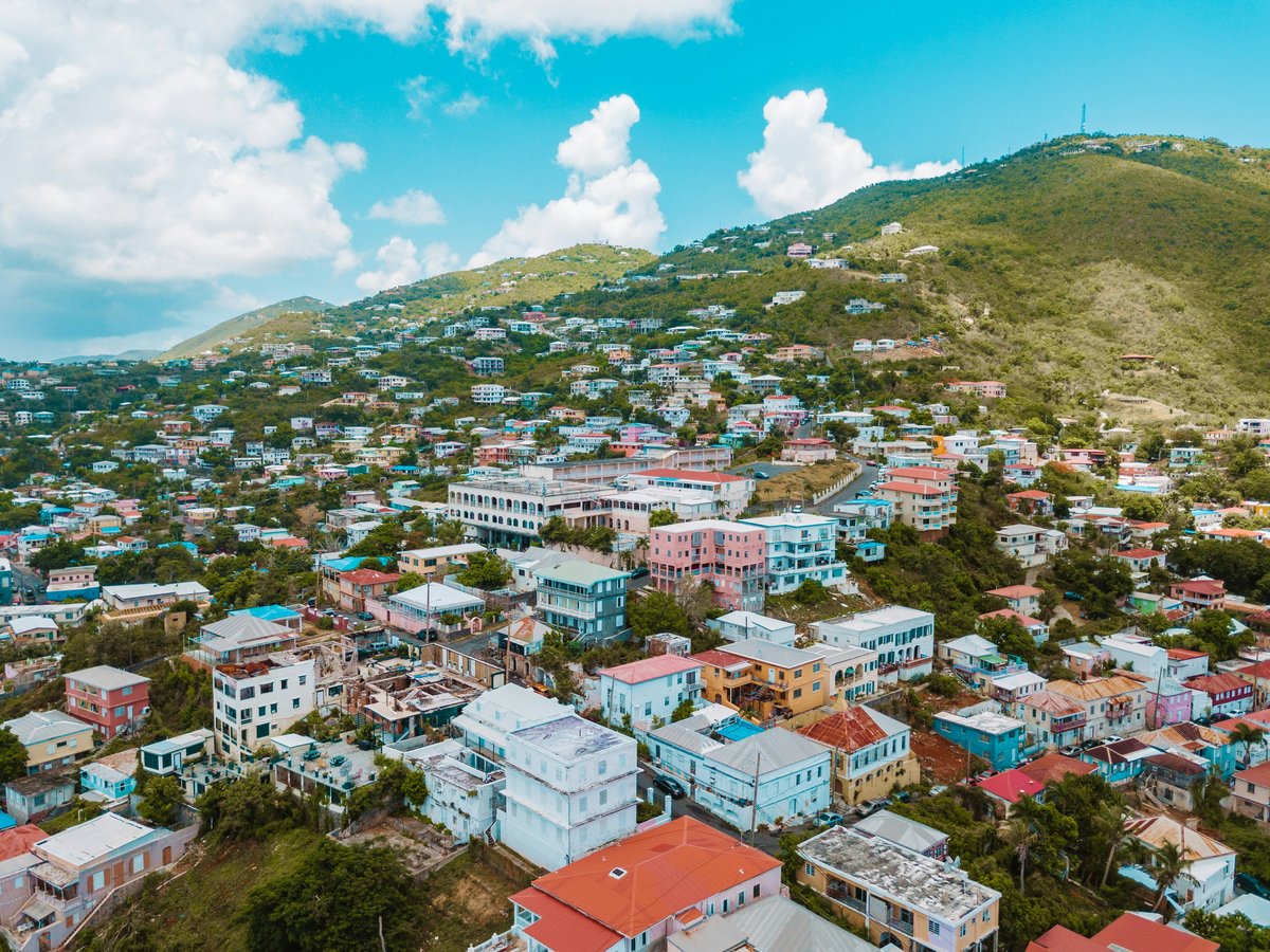
St. Thomas covers roughly 32 square miles of volcanic ridgeline dropping steeply into the Caribbean Sea. Crown Mountain, the island's high point, reaches 1,556 feet. Charlotte Amalie, the territorial capital, wraps around one of the deepest natural harbors in the region, and the town's steep streets hint at the terrain waiting inland. The north shore faces the open Atlantic and catches regular swells. The south coast looks toward the calmer Caribbean. That split shapes the whole outdoor experience here. Humidity tends to hover near 79% through the late-summer months, and September heat indexes push past 32°C by midday. Mind you, the island's compact footprint keeps any trailhead, beach, or kayak launch within a 15-to-20-minute drive. The outdoor character tilts heavily toward water, but the interior hills hold dry tropical forest with short, steep trails that might surprise visitors expecting nothing beyond sand. St. Thomas rates 8.2/10 for family friendliness (see the TTDI Family-Friendliness Index), partly because the sheer number of sheltered coves and shallow reef flats suit groups with mixed ability levels.
Outdoor activities
-
Catamaran Day Sails from Red Hook
Day sails out of Red Hook and Crown Bay head toward spots like Christmas Cove off Great St. James Island or over to Buck Island, the small rocky island northeast of St. Thomas. Most trips run 4 to 6 hours and include snorkel stops, lunch, and open bar. The sail to Christmas Cove takes about 30 to 40 minutes from Red Hook. You'll likely see spotted eagle rays in the sandy channels between reef patches. On calm days the water in Christmas Cove is warm enough that you lose track of how long you've been floating. Full-day sails sometimes cross to the British Virgin Islands, though you'll need a passport for the BVI port stop.
- Difficulty
- Easy
- Duration
- 4 to 6 hours
- Best season
- December through April
-
Parasailing over Charlotte Amalie Harbor
Several operators run flights from the Charlotte Amalie waterfront, with rides typically lifting you to 600 to 800 feet above the harbor. From that altitude, Hassel Island, Water Island, and the cruise ship docks look like a scale model below. The airtime itself lasts about 8 to 12 minutes. Operators generally require calm winds below 20 knots, so cancellations happen more often during hurricane season. Most companies accept passengers as young as 6 years old with an accompanying adult.
- Difficulty
- Easy (no experience needed)
- Duration
- 1 to 1.5 hours including boat time
- Best season
- December through May
-
Deep-Sea Fishing Charters
St. Thomas hosts the USVI Open/Atlantic Blue Marlin Tournament, typically held in August, one of the oldest billfish tournaments in the Caribbean. Charter boats depart from Red Hook and Sapphire Marina, heading north to the North Drop, a deepwater ledge where the ocean floor drops from 100 feet to over 1,000 feet within a short distance. Blue marlin, wahoo, mahi-mahi, and yellowfin tuna are the primary targets out there. Half-day charters run roughly $600 to $900 for up to 6 passengers, while full-day trips to the North Drop start around $1,200. Inshore half-day trips work better for families, targeting barracuda and kingfish closer to the reef line.
- Difficulty
- Moderate (physical endurance for big-game species)
- Duration
- 4 to 8 hours
- Best season
- April through October for peak blue marlin
-
Road Cycling and Mountain Biking
The roads on St. Thomas's north side offer steep climbing with serious elevation change, and the route from Charlotte Amalie over the central ridge toward Magens Bay hits grades above 15% in sections. There are no dedicated mountain bike trails on the island, so riders share the road with vehicle traffic on narrow, winding pavement. The descent toward the north shore runs through dense secondary forest, with mango and flamboyant trees forming a canopy overhead. Rental shops in Red Hook and Charlotte Amalie carry basic mountain bikes, typically for $40 to $60 per day. Serious riders bring their own. December through March offers the most comfortable conditions for sustained climbing.
- Difficulty
- Moderate to difficult
- Duration
- 2 to 3 hours
- Best season
- December through March
Day hikes
-
Hassel Island Trails
Hassel Island sits in Charlotte Amalie harbor, reachable by a short water taxi from the waterfront. The island falls under the Virgin Islands National Park system. Two main trail segments lead to Fort Willoughby, a British-era fortification on the southern tip, and the Creque Marine Railway, a 19th-century haul-out facility with rusting iron track still visible on the stone slipway. The paths are rocky and overgrown in places, with cactus and dry scrub along most of the route. There is very little shade and no facilities or water on the island. Bring at least a liter per person. The views back toward Charlotte Amalie and the harbor cruise ships are clear from the higher points.
- Difficulty
- Moderate (steep, rocky, exposed to sun)
- Duration
- 2 to 3 hours round trip
- Best season
- November through April
-
Water Island to Honeymoon Beach and Fort Segarra
Water Island, sometimes called the fourth Virgin Island, is a 10-minute ferry ride from Crown Bay Marina. The walk from the ferry dock to Honeymoon Beach follows a paved road that becomes a dirt path, with gentle elevation changes over about half a mile. Honeymoon Beach has a small bar, lounge chairs for rent, and decent snorkeling off the western rocks. Past the beach, the path continues to Fort Segarra, an unfinished World War II fortification built into the hillside. The concrete bunkers are dark and cool inside, a sharp contrast to the heat outside. The full walk from dock to fort and back takes about 90 minutes at a casual pace.
- Difficulty
- Easy
- Duration
- 1.5 to 2 hours including beach time
- Best season
- Year-round
-
Crown Mountain Road Walk
There is no formal summit trail on St. Thomas, but the paved roads and side streets near the island's highest ground offer steep walking through residential neighborhoods and secondary forest. Grades hit 15 to 20% in sections. Start early to dodge midday heat, and walk facing traffic since there are no sidewalks. The vegetation shifts as you climb, from dry coastal scrub at lower elevations to a denser canopy of banana, mango, and breadfruit trees above 800 feet. You'll pass goats, chickens, and the occasional mongoose on the road. Few tourists walk these roads, so expect some curious looks from residents.
- Difficulty
- Moderate to difficult (steep road grades, no sidewalks, vehicle traffic)
- Duration
- 2 to 4 hours depending on route
- Best season
- December through March
-
Caneel Hill via Cruz Bay, St. John (Day Trip)
The Red Hook to Cruz Bay ferry runs every hour and takes about 20 minutes, costing around $7 each way. From Cruz Bay, the Caneel Hill Trail climbs through dry forest to a ridgeline with views down to Caneel Bay. The trail is well-marked with National Park Service signs and covers roughly 2 miles round trip with several hundred feet of elevation gain. Footing is loose rock in places, and the lower sections can be muddy after rain. Shade coverage is moderate, with exposed ridgeline near the top. This is likely the most accessible St. John hike for day-trippers staying on St. Thomas.
- Difficulty
- Moderate
- Duration
- 3 to 4 hours including ferry each way
- Best season
- December through April
Water activities
-
Snorkeling at Coki Beach
Coki Beach sits on the north side of St. Thomas near Coral World Ocean Park. The reef starts within 30 feet of shore in waist-deep water, which makes it one of the easiest reef-access points on the island. Blue tang, parrotfish, yellowtail snapper, and the occasional sea turtle are regular sightings. The bottom transitions from sand to live coral as you move out, with visibility reaching 50 to 60 feet on calm days. Gear rentals run about $10 to $15 on the beach. The spot gets crowded when cruise ships dock, so weekday mornings before 10 AM tend to be the best window.
- Difficulty
- Easy
- Duration
- 2 to 3 hours
- Best season
- Year-round, calmest November through May
-
Swimming and Paddleboarding at Magens Bay
Magens Bay is a sheltered crescent on the north coast with a gentle sandy bottom and minimal current. The bay stretches about three-quarters of a mile, and a full paddleboard circuit along the shoreline covers roughly 1.5 miles. SUP and kayak rentals are available on the beach for around $25 to $35 per hour. Water temperature stays between 79 and 84°F year-round. The bay charges a $5 entrance fee per person. Early mornings before 9 AM tend to have the glassiest water, and you might spot a sea turtle feeding on the seagrass patches near the headlands.
- Difficulty
- Easy
- Duration
- Half day
- Best season
- Year-round
-
Diving at Virgin Islands Coral Reef National Monument
The Virgin Islands Coral Reef National Monument, established in 2001, protects roughly 12,700 acres of submerged lands south of St. Thomas and St. John. Dive operators based in Red Hook run boat trips to sites within the monument where wall dives drop past 100 feet. The reef systems include brain coral, elkhorn coral, and large sea fans that sway in the current. Visibility ranges from 60 to over 100 feet on good days. Current can run moderate to strong at certain sites, so this water is better suited to certified divers. Operators require proof of open-water certification before boarding.
- Difficulty
- Moderate to advanced (boat access, potential current)
- Duration
- Half day to full day
- Best season
- December through May
-
Kayaking at Mangrove Lagoon (STEER)
The St. Thomas East End Reserve protects roughly 1,000 acres of mangrove habitat and seagrass beds along the island's southeast coast near Bovoni. Guided kayak tours paddle through narrow red-mangrove channels where juvenile fish school among the root systems and pelicans roost in the branches overhead. The water stays shallow, rarely more than 4 feet deep in the channels. You might spot hawksbill turtles in the seagrass flats on calm mornings. Several outfitters launch from the Bovoni area, with morning departures around 8:30 or 9:00 AM to beat the afternoon heat.
- Difficulty
- Easy
- Duration
- 2 to 3 hours
- Best season
- December through April
-
Brewers Bay Beach Snorkeling
Brewers Bay sits on the island's west side near the University of the Virgin Islands campus. The beach draws fewer tourists than the north-shore spots and has coarser sand with a more natural, ungroomed feel. A rocky reef on the eastern edge of the bay holds sea fans and brain coral in 8 to 15 feet of water, and green sea turtles are regularly sighted feeding on the seagrass beds. Facilities are minimal, with a few picnic tables and roadside parking. The bay faces south, so it stays calmer than north-shore beaches during winter ground swells.
- Difficulty
- Easy
- Duration
- 2 to 3 hours
- Best season
- Year-round
Parks & gardens
-
Emancipation Garden
FreeThis compact public square in central Charlotte Amalie commemorates the 1848 proclamation that ended slavery in the Danish West Indies. A replica of the Philadelphia Liberty Bell stands at one end. The garden has shaded benches under mature mahogany and palm trees, and you'll hear foot traffic and vendor calls from Main Street a block away. Local sellers sometimes offer coconut water and fresh mango at the garden's edges. The space draws the most visitors when cruise ships are in port, typically between 9 AM and 3 PM.
Highlights: Replica Liberty Bell, mature shade canopy, proximity to Charlotte Amalie's waterfront and Main Street shopping district
-
Lionel Roberts Park
FreeCharlotte Amalie's primary recreation facility sits in the Sub Base neighborhood on the west side of town. The park holds a baseball diamond, basketball courts, and open green space. Local softball leagues and pickup basketball run most Saturday and Sunday mornings, and the sound of aluminum bats and reggaeton from parked cars carries across the field. The grounds are functional rather than ornamental, built for community sports rather than garden strolling. Shade is limited, so bring a hat for any midday visit.
Highlights: Baseball diamond, basketball courts, local sports leagues on weekend mornings
-
Estate St. Peter Greathouse and Botanical Gardens
This restored plantation estate sits at about 1,000 feet elevation on St. Thomas's northern slope, with grounds holding over 200 varieties of tropical plants. The collection includes orchids, bromeliads, and a section of native Caribbean palms. A self-guided path winds through the gardens, and on humid afternoons you can hear tree frogs calling from the undergrowth. The property looks out over Magens Bay and the surrounding coves. The Great House and gardens were largely replanted after Hurricane Irma's damage in September 2017.
Highlights: Orchid collection, panoramic north-shore views, self-guided botanical walk at 1,000-foot elevation
-
Drake's Seat
FreeThis roadside overlook on the ridge between Charlotte Amalie and Magens Bay sits at roughly 1,100 feet elevation. Local tradition connects the site to Sir Francis Drake, who reportedly watched for Spanish ships from this vantage in the 1580s. The viewing area is compact, with a stone bench, a few vendor stalls selling cold drinks, and usually a line of taxis. On clear mornings you can pick out individual islands in the British Virgin chain to the north. The trade winds run stronger here than anywhere in Charlotte Amalie below, and the air is noticeably cooler.
Highlights: Ridge-top panorama of Magens Bay and the BVI, trade-wind breeze, roadside vendor stalls
Practical tips
- Sun Protection
- The UV index on St. Thomas reaches 11 to 12 during summer and stays at 8 to 9 even in December. USVI territorial law requires reef-safe sunscreen (non-nano zinc oxide or titanium dioxide) at beaches. Reapply every 80 minutes in the water. A rash guard or long-sleeve UV shirt prevents the raw-neck burn that snorkel-mask straps cause and cuts sunscreen use in half.
- Hydration
- Carry at least 1 liter of water per person per hour for any hike. Humidity above 75% accelerates fluid loss faster than most visitors expect. Tap water on St. Thomas comes from a desalination plant and is safe to drink. Convenience stores in Red Hook and Charlotte Amalie sell gallon jugs for $3 to $4.
- Trail Conditions
- St. Thomas has very few maintained hiking trails compared to neighboring St. John, which benefits from National Park Service funding. Most island paths are old roads, social trails, or goat tracks. Footing is often loose volcanic rock, and after rain the red clay soil turns slick. Closed-toe shoes with real tread are necessary for anything beyond a beach walk.
- Gear Rentals and Packing
- Snorkel gear rents for $10 to $20 at most beaches, but fit varies widely. If you plan to snorkel more than twice, buying a decent mask and dry snorkel from a Red Hook shop for $25 to $40 pays for itself. Bring a dry bag for phones on any kayak or boat trip. A lightweight rain shell is useful from June through November, when squalls can form with about 10 minutes of warning.
- Timing and Heat Management
- Start any hike or paddle before 9 AM. By midday the combination of temperature, humidity, and reflected glare off water or rock becomes genuinely oppressive. The trade winds on north-side beaches provide some relief, but south-facing spots can feel still and airless on calm days. December through March is the most comfortable period for sustained outdoor effort.
- Getting to Trailheads
- Public buses run through the VITRAN system, but routes are infrequent and skip most trailheads (for transit details, see https://en.wikivoyage.org/wiki/St._Thomas#Get_around). Open-air safari taxis cover set routes between Charlotte Amalie, Red Hook, and the cruise docks. For hiking or kayaking, a rental car is the practical choice. Driving is on the left side of the road, a holdover from Danish colonial rule, and the mountain roads are narrow with blind switchbacks.
FAQ
What is the best time of year for outdoor activities on St. Thomas?
December through April brings lower humidity, temperatures in the mid-70s to mid-80s°F, calmer seas, and minimal rain. Hurricane season runs June 1 through November 30, with September and October carrying the highest storm risk. That said, many visitors enjoy summer outdoor activities since afternoon storms tend to be brief and water temperatures reach their warmest.
Do I need a rental car to reach trailheads and beaches on St. Thomas?
For most outdoor spots beyond Charlotte Amalie and the major beaches, yes. Safari taxis can get you to Magens Bay and Red Hook, but reaching places like Hull Bay, Bovoni, or the higher-elevation roads without your own vehicle is difficult. Rental rates on St. Thomas typically run $50 to $80 per day.
Is St. Thomas safe for solo outdoor activities?
St. Thomas scores 6.2/10 for solo-traveler safety (see the TTDI Solo-Safety Index). For outdoor activities specifically, the main risks are sun exposure, dehydration, and isolation on unmarked trails rather than crime. Swim at beaches where other people are present, carry a charged phone, and let someone know your plans when heading to less-visited spots. For neighborhood-level guidance, the overview at https://en.wikivoyage.org/wiki/St._Thomas#Stay_safe is a useful starting point.
Are permits required for hiking, snorkeling, or water sports on St. Thomas?
No permits are needed for beach access, snorkeling, paddleboarding, or kayaking at public beaches and bays. Magens Bay charges a per-person entrance fee as noted above. Hassel Island is managed by the National Park Service with no separate entry fee, though access depends on water taxi schedules. Dive operators and fishing charter companies handle any required USCG or USVI licensing on their end.
Can I snorkel safely without a guide on St. Thomas?
Several beaches offer reef access directly from shore. Coki Beach, described in the water activities section, has reef in shallow water close to the sand. Check conditions before entering, stay inside any buoy lines to avoid boat traffic, and never touch live coral. Current tends to be minimal inside protected bays but can build at headland points and in open channels between islands.
Last verified by automated review (v1.7.2) on . What is automated review?