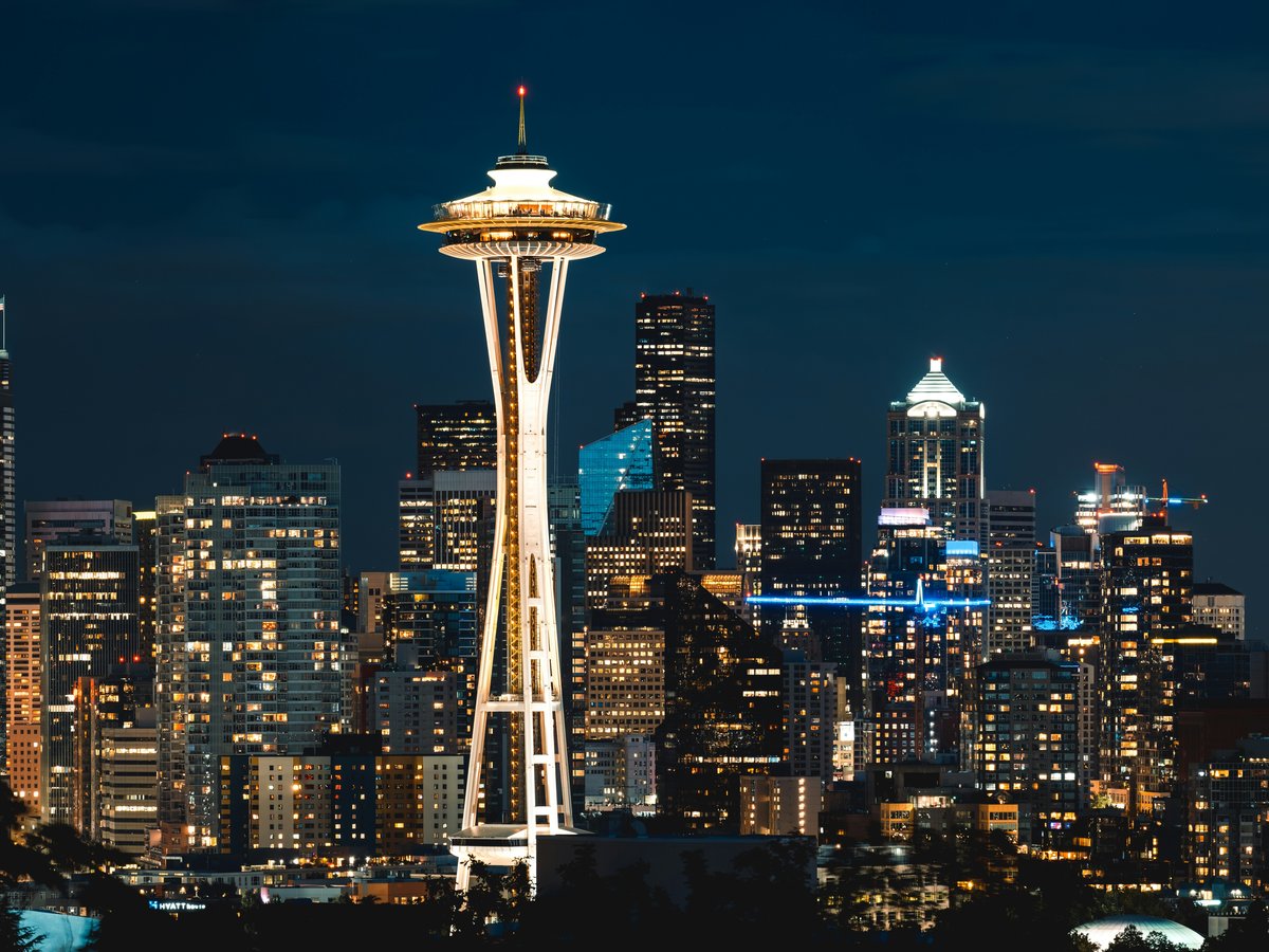
Seattle tends to confuse first-time visitors because it doesn't follow a clean grid. The city sits on a narrow isthmus between Puget Sound to the west and Lake Washington to the east, with the Lake Washington Ship Canal cutting it roughly in half. Downtown occupies about 30 blocks of hills along Elliott Bay, and neighborhoods fan out from there in ways that feel more organic than planned. South of the canal you'll find the older, denser districts. Capitol Hill rises steeply east of downtown, Fremont and Ballard spread along the north shore of the canal, and the University District clusters around the UW campus further northeast. The topography matters here. Seattle has something like 18 named hills, and the elevation changes mean two neighborhoods separated by 10 minutes on a map can feel like different cities. The light rail runs north-south along a single line from Lynnwood to Angle Lake, with a second line to Bellevue and Redmond that opened in 2024. Buses fill the gaps, but this is still largely a car-and-rideshare city outside the downtown core. One thing worth knowing early on. The neighborhoods north of the Ship Canal tend to feel more residential and slower-paced, while everything south of it carries more grit, more density, and more of the city's older character.
Neighborhoods
-
Pike Place and Downtown
The commercial spine of the city runs along 1st through 5th Avenues between Stewart Street and Pioneer Square. Pike Place Market has operated since 1907, and despite drawing roughly 10 million visitors a year, it still functions as a real market. Fishmongers, flower sellers, and produce vendors open by 6 AM most mornings. The noise level is constant. Delivery trucks on the cobblestones, buskers competing for spots near the brass pig statue, tourists crowding the original Starbucks at 1912 Pike Place. Beyond the market, downtown feels like a mid-tier American business district. Glass office towers, chain hotels, a few good restaurants tucked between parking garages. The retail core along Pine Street between 3rd and 6th has thinned out since Nordstrom closed its flagship in 2024. That said, the waterfront renovation south of Pier 62 has added about 20 acres of new public space along Alaskan Way.
- Best for
- First-time visitors, business travelers, and anyone who wants walkable access to the market, the waterfront, and the Seattle Art Museum on 1st Avenue
- Key streets
- Pike Place and the market's lower levels (Down Under shops). 1st Avenue between Union and Pike for bars and restaurants. The new waterfront promenade along Alaskan Way. 3rd Avenue is the main bus corridor but feels rough after dark.
-
Capitol Hill
Capitol Hill sits on a ridge east of downtown, centered on Broadway and the Pike-Pine corridor between Melrose Avenue and 15th Avenue East. This has been the heart of Seattle's LGBTQ+ community since at least the 1970s, and that identity still holds, though rising rents have pushed some of the older bars and community spaces out. The architecture is a mix of early-1900s brick apartment buildings, Craftsman houses on the residential streets east of 15th, and newer 5-over-1 mixed-use blocks that started going up around 2015. The density of restaurants and bars per block along Pike and Pine between Broadway and Summit Avenue is probably the highest in the city. Noise carries late, especially on weekends. You'll hear music from venues like Neumos or Barboza bleeding onto the sidewalk past midnight. Volunteer Park sits at the north end of the hill, 48 acres with a conservatory built in 1912 and views of the Space Needle from the old water tower.
- Best for
- Younger travelers, food-focused visitors, anyone who wants nightlife within walking distance and doesn't mind steep hills
- Key streets
- Pike Street and Pine Street between Melrose and Broadway for restaurants and bars. 15th Avenue East for a quieter row of coffee shops and bookstores, including Elliott Bay Book Company. Broadway for transit (the First Hill Streetcar stops here) and casual dining. 10th Avenue East near Prospect Street for the approach to Volunteer Park.
-
Fremont
Fremont occupies about 15 blocks on the north bank of the Lake Washington Ship Canal, west of the Aurora Bridge. It declared itself the Center of the Universe in 1994 and put up a sign to prove it, which tells you something about the neighborhood's personality. There's a Cold War-era rocket bolted to the side of a building on Evanston Avenue North, and a concrete troll sculpture under the Aurora Bridge that dates to 1990. The commercial strip runs along North 34th and 35th Streets, and it has the feel of a small town that happens to sit inside a city. Theo Chocolate's factory on Phinney Avenue North still does tours. The Sunday Market operates from about April through December under the Fremont Bridge, drawing maybe 100 vendors on a good weekend. The pace here is slower than Capitol Hill or downtown by a wide margin.
- Best for
- Couples, repeat visitors who've already done the tourist circuit, and anyone who appreciates a neighborhood that doesn't take itself seriously
- Key streets
- North 34th Street from the Fremont Bridge to Evanston Avenue North for shops and cafes. North 36th Street for the Fremont Troll under the Aurora Bridge. Phinney Avenue North heading into the zoo district. The Burke-Gilman Trail passes through along the canal, good for running or cycling.
-
Ballard
Ballard was an independent city until Seattle annexed it in 1907, and it still carries some of that separateness. The old downtown core along Ballard Avenue NW between 20th Avenue NW and 22nd Avenue NW is a row of early-1900s brick buildings, many of them former saloons and hardware stores that served the neighborhood's Scandinavian fishing community. That strip now holds some of the best restaurants in the city. The Walrus and the Carpenter does oysters that regularly make national lists. Stoneburner does Mediterranean-influenced wood-fired cooking. On weekend evenings, Ballard Avenue gets loud. The brewery density is notable. Within about 8 blocks you'll find Reuben's Brews, Stoup Brewing, and Peddler Brewing, among others. The Hiram M. Chittenden Locks at the west end of the neighborhood connect Puget Sound to the Ship Canal and see about 1 million visitors per year. Watching boats transit the locks never quite gets old. There's also a fish ladder where you can watch salmon heading upstream, typically peaking around September.
- Best for
- Beer lovers, seafood-focused eaters, anyone who wants a neighborhood with real history and good restaurants within a 6-block walk
- Key streets
- Ballard Avenue NW between NW Market Street and NW Dock Place for restaurants and bars. NW Market Street for everyday shopping and the Ballard Farmers Market on Sundays (year-round, rain or shine). NW 54th Street heading west toward the Locks.
-
Georgetown
Georgetown sits south of the stadiums, tucked between I-5 and the Duwamish Waterway. It was Seattle's first settlement, platted in 1890, and it shows. The buildings along Airport Way South and Corson Avenue South are industrial-era brick and corrugated metal, many of them converted into art studios, small breweries, and dive bars. The neighborhood still has working warehouses, so you'll hear trucks during the day and smell something faintly metallic when the wind comes off the river. This is where Seattle's punk and DIY art scene has lived since artists got priced out of Capitol Hill around 2010. The Georgetown Art Attack, a free gallery walk, happens the second Saturday of each month. Fantagraphics Bookstore and Gallery on South Vale Street is one of the best independent comics shops in the country. Georgetown Brewing on 6th Avenue South makes one of the better IPAs in the Pacific Northwest and doesn't bottle it, so you can only get it fresh on tap locally.
- Best for
- Art-oriented travelers who don't need polished surfaces, beer drinkers, anyone who wants to see a Seattle that predates the tech boom
- Key streets
- Airport Way South from South Lucile Street to South Homer Street for bars, galleries, and shops. Corson Avenue South for studios and the brewery district. South Vale Street for Fantagraphics.
-
University District
The U-District wraps around the University of Washington campus, which enrolls roughly 47,000 students. The Ave, as locals call University Way NE, runs parallel to campus and has the feel you'd expect. Cheap pho at Thai Tom (cash only, 4 stools at the counter, the wok flame is visible from the sidewalk). Ramen from Kukai on NE 43rd Street. Used bookstores. The area north of NE 50th Street gets quieter and more residential. The neighborhood took a hit during the pandemic when a lot of small businesses closed, but the U District light rail station that opened in 2021 has brought new foot traffic. University Village, technically at the northeast edge, is a different world entirely. An upscale outdoor mall with an Apple Store, Din Tai Fung, and a Molly Moon's ice cream location. The contrast between The Ave and U Village is about $15 per entree.
- Best for
- Budget-minded travelers, students, anyone who wants proximity to the Burke-Gilman Trail and easy light rail access to downtown (about 8 minutes)
- Key streets
- University Way NE (The Ave) from NE 40th to NE 50th Street for food and shops. NE 45th Street heading east toward University Village. The Burke-Gilman Trail cuts through campus heading east toward Kenmore. NE Campus Parkway for a few solid coffee shops and the Neptune Theatre.
-
Queen Anne
Queen Anne splits into two distinct zones. Lower Queen Anne (sometimes called Uptown) sits at the base of the hill near Seattle Center, home to the Space Needle, MoPOP, and the Chihuly Garden and Glass museum. It's hotel-dense, transit-accessible, and slightly corporate. The restaurants here cater to pre-show theater crowds. The Seattle Repertory Theatre and Intiman Theatre are both within a few blocks. Upper Queen Anne, on top of the hill, feels like a different neighborhood entirely. The commercial strip on Queen Anne Avenue North between West Galer and West McGraw Streets is about 4 blocks of bakeries, wine shops, and restaurants that serve mostly locals. The views from Kerry Park on West Highland Drive are the postcard shot of Seattle. Space Needle in the foreground, Mount Rainier behind, Elliott Bay to the left. On a clear day in late afternoon the light is genuinely good.
- Best for
- Families with kids (Seattle Center's museums and playground are a strong draw), theatergoers, first-time visitors who want a quieter base than downtown
- Key streets
- Queen Anne Avenue North from Mercer Street (lower) up to McGraw Street (upper) for the full range. West Highland Drive for Kerry Park. 1st Avenue North near Seattle Center for pre-event dining. Taylor Avenue North for the Counterbalance Park area.
-
Columbia City
Columbia City sits along Rainier Avenue South, roughly 5 miles southeast of downtown. The light rail stop (Columbia City Station) makes it about 15 minutes to Westlake Center. The commercial strip on South Edmunds Street and Rainier Avenue has a density of independent restaurants that punches well above the neighborhood's size. The population here is genuinely mixed in a way that most Seattle neighborhoods haven't been for a decade or more. You'll hear Amharic, Vietnamese, Spanish, and Somali spoken within a few blocks. The food reflects that. Tutta Bella does Neapolitan pizza (about $17 for a margherita). Pho Cyclo on Rainier has been open since the late 1990s and still draws a line on Saturday mornings. Island Soul does Caribbean-Creole food with jerk chicken plates for around $15. On the first Thursday of each month, the galleries and shops stay open late for the Columbia City Gallery Walk.
- Best for
- Travelers who want a residential neighborhood with real diversity and excellent food, anyone comfortable being a 15-minute train ride from the tourist center
- Key streets
- Rainier Avenue South between South Alaska Street and South Edmunds Street for the main commercial strip. South Edmunds Street for the gallery walk and the Columbia City Cinema (one of the last single-screen theaters in the city). Genesee Park is about a 10-minute walk east toward Lake Washington.
-
West Seattle
West Seattle feels geographically cut off from the rest of the city because it sort of is. The West Seattle Bridge closure from 2020 to 2022 made that isolation literal. Even with the bridge reopened, getting here from downtown means either the bridge or taking the lower Spokane Street route, both of which bottleneck during rush hour. The water taxi from Pier 50 to Seacrest Dock is a better option, about 10 minutes and $5.75 each way. The neighborhood's heart is the Alaska Junction, centered on California Avenue SW and SW Alaska Street. It has a small-town main street quality. Independent shops, the Easy Street Records store (open since 1988), a few solid restaurants. Alki Beach runs about 2.5 miles along the northwestern shore and is the closest thing Seattle has to a Southern California beach scene, which means it gets crowded on any day above 75 degrees. The views of the downtown skyline from Alki Point are worth the trip alone.
- Best for
- Beach-oriented visitors in summer, families, anyone who wants a slower pace and doesn't mind being 20 to 30 minutes from downtown
- Key streets
- California Avenue SW through the Alaska Junction for shops and restaurants. Alki Avenue SW along the beach from Duwamish Head to Alki Point. Admiral Way SW heading toward the Admiral District, a smaller commercial node with the Admiral Theater (built 1942). SW Admiral Way near Hamilton Viewpoint Park for skyline views.
-
Pioneer Square
Pioneer Square is Seattle's oldest neighborhood, rebuilt in brick after the Great Fire of 1889. The Romanesque Revival architecture on 1st Avenue South and South Jackson Street is some of the most distinctive in the city. The pergola at Pioneer Place Park dates to 1909. The Bill Speidel Underground Tour takes you beneath the sidewalks to see the original street-level storefronts that were buried when the city regraded after the fire. The neighborhood has struggled with homelessness and vacancy for years, and that's still visible, particularly around Occidental Square after dark. But recent investment has brought in some strong additions. Zeitgeist Coffee on South Jackson Street has been an anchor for 20-plus years. London Plane on Occidental Avenue South does a brunch that draws from the entire city. The galleries along 1st Avenue South, particularly Greg Kucera Gallery and Foster/White, show serious contemporary work.
- Best for
- History-focused travelers, architecture fans, gallery visitors who don't mind a neighborhood that's still in transition
- Key streets
- 1st Avenue South between Yesler Way and South King Street for galleries and restaurants. Occidental Avenue South for the pedestrian mall and London Plane. South Jackson Street heading east toward the International District. Yesler Way, the original Skid Road (the term originated here in the 1850s when logs were skidded down the hill to Henry Yesler's sawmill).
-
South Lake Union
South Lake Union barely existed as a neighborhood 15 years ago. It was warehouses, laundromats, and a few marine repair shops on the south shore of Lake Union. Then Amazon built its headquarters here starting around 2010, and now the area is dominated by the company's campus. The Spheres, those three glass domes on 7th Avenue, opened in 2018 and contain over 40,000 plants. The surrounding blocks are new construction, mostly 6-to-8 story office buildings and apartment towers with ground-floor restaurants. MOHAI (the Museum of History and Industry) moved to a renovated Naval Reserve building on the lake in 2012 and is worth 2 hours. The neighborhood has a clean, corporate feel during the week. Weekends it's quieter. The Center for Wooden Boats on the south shore of Lake Union rents rowboats and small sailboats, and on Sunday mornings the free public sail program puts you on the water at no cost.
- Best for
- Business travelers visiting Amazon or tech companies, anyone who wants newer hotels and restaurants near the lake without being in the thick of downtown
- Key streets
- Westlake Avenue North along the lake for MOHAI and the wooden boats. Terry Avenue North for restaurants near the Amazon campus. Denny Way at the southern edge is a major crosstown arterial and connects to Capitol Hill going east. The South Lake Union Streetcar runs along Westlake to downtown.
FAQ
What is the best neighborhood to stay in for a first visit to Seattle?
Queen Anne or downtown Pike Place area gives you walkable access to the major sights. Lower Queen Anne puts you near Seattle Center (Space Needle, MoPOP, Chihuly), and the Monorail connects you to Westlake Center downtown in about 2 minutes. Downtown hotels near Pike Place Market tend to run $180 to $350 per night depending on season, with summer (July through September) being peak. If you want something less touristy on your first visit, Capitol Hill is about a 10-minute rideshare from the market and has better restaurants per block.
Is Seattle walkable or do I need a car?
Downtown, Capitol Hill, and Ballard are all internally walkable. The hills are real though. Getting from the waterfront to Pike Place Market means climbing a steep 3-block grade that catches people off guard. Between neighborhoods, the Link Light Rail covers the north-south corridor well. The 1 Line runs from Lynnwood to Angle Lake, and a second line opened east to Bellevue and Redmond in 2024. For Ballard, Fremont, or West Seattle, a rideshare or bus is more practical. A car is useful if you're heading to the Locks, Discovery Park (534 acres on Magnolia Bluff), or making day trips, but downtown parking runs $30 to $50 per day.
When is the best time of year to visit Seattle?
July through mid-September gets the most reliable dry weather, with average highs around 75 to 80 degrees Fahrenheit and roughly 15 to 16 hours of daylight. This is peak season and hotel prices reflect it. Late June can still be overcast (locals call it Juneary). October and November bring steady rain, but fall colors around the UW campus quad and Volunteer Park are genuine. The off-season from November to March is wet and gray, with temperatures hovering around 40 to 48 degrees, but hotel rates drop by 30 to 40 percent and you'll have restaurants and museums largely to yourself.
Which neighborhoods have the best food scenes?
Capitol Hill has the highest density of restaurants and bars, concentrated along Pike and Pine Streets between Melrose and Broadway. Ballard Avenue NW runs a close second, with standouts like The Walrus and the Carpenter for oysters and Stoneburner for wood-fired Mediterranean. Columbia City on Rainier Avenue South punches well above its weight with Caribbean, Ethiopian, Vietnamese, and Italian options within 3 blocks. Georgetown is worth the trip for Fonda La Catrina's mole negro alone. For cheap eats, the University District's Ave still has $10-and-under pho and ramen if you know where to look. The International District along South Jackson Street has dim sum at Jade Garden and hand-pulled noodles at Xi'an Noodles.
How far is the airport from central Seattle?
Seattle-Tacoma International Airport sits about 14 miles south of downtown. The Link Light Rail runs directly from the airport to Westlake Center downtown, taking roughly 38 to 40 minutes and costing $3.25. A rideshare typically takes 25 to 50 minutes depending on traffic and costs $30 to $55. Rush hour on I-5 northbound in the afternoon can push a drive past an hour. The light rail is the more predictable option and drops you at University Street Station (downtown), Capitol Hill Station, or U District Station without transfers.
Are Seattle's neighborhoods safe for tourists?
Most tourist-visited neighborhoods, including Pike Place, Capitol Hill, Queen Anne, Ballard, and Fremont, are generally fine during the day and evening. Pioneer Square and parts of 3rd Avenue downtown feel less comfortable after dark, particularly around Occidental Square and the stretch of 3rd between Pine and James Streets. The area around 12th Avenue South and South Jackson Street (Chinatown-International District) has seen increased property crime since 2020. Standard city awareness applies. Keep valuables out of sight in parked cars, especially in Pioneer Square or the U-District. West Seattle and Columbia City feel suburban-safe at most hours.
Last verified by automated review (v1.7.2) on . What is automated review?