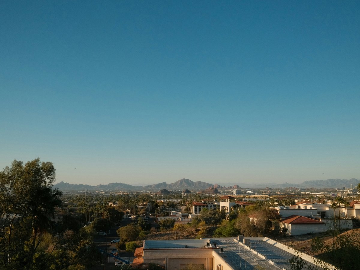
Phoenix sits in the Salt River Valley, ringed by the Sonoran Desert and a surprisingly rugged network of mountain preserves that push right up against the suburbs. The city sprawls at about 1,086 feet elevation, which means mild winters ideal for trail time and summers that regularly crack 110°F. You'll notice saguaro cacti standing 30 or 40 feet tall along ridgelines, palo verde trees throwing thin shade, and the dry mineral smell of caliche dust underfoot. The outdoor culture here tends to revolve around early mornings. By 6 a.m. on a Saturday in March, the Camelback Mountain trailhead parking lot is already full. That tells you something about how seriously Phoenix takes its desert backyard. Worth noting, this is a city where the mountains aren't a day trip. They're embedded in the neighborhoods, visible from nearly every intersection, and walkable from certain apartment complexes.
Outdoor activities
-
Rock Climbing at Camelback Mountain and the Superstitions
The Echo Canyon side of Camelback Mountain has bolted sport routes on volcanic rock in the 5.6 to 5.10 range, and you'll find groups of climbers most cool-season mornings. For trad climbing and longer multi-pitch routes, the Superstition Wilderness about 45 minutes east of the city offers more serious terrain on welded tuff. The Flatiron approach involves some Class 3 scrambling. Bring a helmet for the Superstitions. Rockfall is a real concern in those crumbling canyon walls.
- Difficulty
- Moderate to Advanced
- Duration
- Half day to full day
- Best season
- November through March
-
Mountain Biking in the McDowell Sonoran Preserve
The McDowell Sonoran Preserve in north Scottsdale covers over 30,000 acres of protected desert and currently has more than 225 miles of multi-use trails. The Pemberton Trail is a popular 15-mile loop that rolls through rocky desert terrain with some technical sections. Gateway Loop offers a shorter 4.5-mile introduction. The soil is decomposed granite with embedded rock, so hardtail bikes tend to get rattled. Full suspension helps. Trailheads at Brown's Ranch and Gateway are the busiest.
- Difficulty
- Easy to Intermediate depending on trail
- Duration
- 2 to 4 hours
- Best season
- October through April
-
Road Cycling on the Canal Paths
Phoenix has roughly 180 miles of canal paths, mostly flat paved or packed-gravel surfaces following the old Salt River Project irrigation canals. The Arizona Canal path runs about 46 miles east to west through Scottsdale and north Phoenix. The Grand Canal connects downtown Phoenix to Tempe. These paths stay cooler than open roads because of the mature trees along certain stretches, though shade is inconsistent. You'll share the path with joggers and dog walkers, especially near Arcadia and Old Town Scottsdale.
- Difficulty
- Easy
- Duration
- 1 to 3 hours
- Best season
- October through May
-
Trail Running in South Mountain Park
South Mountain Park and Preserve spans over 16,000 acres, making it one of the largest municipal parks in the country. The National Trail runs roughly 14.3 miles end to end across the ridge. Most trail runners tackle shorter out-and-back sections, and the Mormon Trail to Hidden Valley loop covers about 4 miles with enough elevation change to keep it honest. The footing is rocky in most spots. Road shoes won't cut it. Trail runners with good grip and rock plates are worth the investment here.
- Difficulty
- Moderate to Difficult
- Duration
- 1 to 4 hours
- Best season
- October through April
-
Horseback Riding in the Tonto National Forest
Several outfitters near the Apache Trail run guided horseback rides into the Tonto National Forest northeast of the city. MacDonald's Ranch in north Scottsdale offers 1- to 2-hour desert rides that stay relatively flat. The Saguaro Lake Ranch runs rides along the Salt River with views of the Four Peaks Wilderness. Rides tend to cost between $50 and $100 per hour depending on group size. The horses know the trails well, which makes these accessible for beginners, but the summer heat shuts most operations down from June through September.
- Difficulty
- Easy to Moderate
- Duration
- 1 to 3 hours
- Best season
- November through March
-
Hot Air Ballooning over the Sonoran Desert
Phoenix is one of the more active ballooning cities in the U.S., partly because the calm morning air in the desert creates predictable flying conditions from October through May. Most flights launch around sunrise from north Scottsdale or north Phoenix and drift over fields of saguaros for about 60 to 90 minutes. Expect to pay $200 to $300 per person. Rainbow Ryders and Hot Air Expeditions are two of the longer-running operators in the area. Landings are in open desert, so wear closed-toe shoes.
- Difficulty
- Easy (passenger activity)
- Duration
- 3 to 4 hours including setup and champagne
- Best season
- October through April
Day hikes
-
Camelback Mountain via Echo Canyon Trail
The Echo Canyon Trail climbs about 1,280 feet in 1.2 miles to the 2,704-foot summit of Camelback Mountain. That's steep by any measure. The trail includes handrail-assisted rock scrambles in the upper section and exposed ridgeline walking near the top. Expect company. This is likely the most popular summit hike in the Phoenix metro area, and the parking lot at the Echo Canyon trailhead fills before 7 a.m. on cool-season weekends. Bring more water than you think you'll need.
- Difficulty
- Difficult (steep, exposed, Class 2-3 scrambling)
- Duration
- 1.5 to 3 hours round trip
- Best season
- October through April
-
Piestewa Peak Summit Trail (Trail 300)
Piestewa Peak rises to 2,608 feet and the Summit Trail covers about 1.2 miles one way with roughly 1,190 feet of elevation gain. The trail is well-maintained with stone steps in the steeper sections, though the final push to the summit involves some hand-over-foot rock work. It's a notch less technical than Camelback but still a solid workout. The Dreamy Draw area at the base has a few easier connector trails if you want to extend the outing on flatter ground.
- Difficulty
- Moderate to Difficult
- Duration
- 1.5 to 2.5 hours round trip
- Best season
- October through April
-
Flatiron via Siphon Draw Trail, Superstition Wilderness
The Siphon Draw Trail starts at Lost Dutchman State Park, about 40 miles east of central Phoenix. The route to the Flatiron covers roughly 5.6 miles round trip with about 2,800 feet of total elevation gain. The first mile is gentle desert walking. Then the trail enters a narrow canyon with pour-offs that require scrambling. The final approach to the Flatiron summit involves exposed Class 3 terrain on loose rock. This is not a beginner hike. People get rescued here regularly, especially in warm weather. Lost Dutchman charges a $7 per vehicle entry fee.
- Difficulty
- Difficult (Class 3 scrambling, significant exposure)
- Duration
- 4 to 6 hours round trip
- Best season
- November through March
-
Tom's Thumb Trail, McDowell Sonoran Preserve
Tom's Thumb Trail runs about 4.4 miles round trip with around 1,100 feet of elevation gain, ending at a distinctive granite spire in the McDowell Mountains. The trail crosses several washes before climbing through boulder fields. Footing is rocky but manageable for anyone comfortable on uneven terrain. The Tom's Thumb formation itself sits at about 3,400 feet and gives clear views north toward the Verde River valley. Trailhead parking at the north end of 128th Street fills on weekends.
- Difficulty
- Moderate
- Duration
- 2 to 3 hours round trip
- Best season
- October through April
-
Holbert Trail to Dobbins Lookout, South Mountain
Holbert Trail climbs about 2.5 miles one way with roughly 600 feet of gain to Dobbins Lookout, the highest accessible point in South Mountain Park. The trail passes a set of Hohokam petroglyphs in the first half mile, which is worth pausing for. The grade stays manageable throughout, with a few switchbacks near the top. You can also drive to Dobbins Lookout via Summit Road, so the overlook itself tends to be crowded even when the trail isn't. Views from the top stretch across the entire Salt River Valley.
- Difficulty
- Easy to Moderate
- Duration
- 2 to 3 hours round trip
- Best season
- October through April
-
Peralta Trail to Fremont Saddle, Superstition Wilderness
The Peralta Trail covers about 4.6 miles round trip with 1,350 feet of elevation gain, ending at Fremont Saddle with a direct view of Weaver's Needle, a 4,553-foot volcanic spire. The trail follows Peralta Canyon through thick desert vegetation. Saguaros crowd the slopes, and in a good wildflower year (typically late March), the canyon floor turns orange with Mexican gold poppies. The trailhead is about an hour's drive east of Phoenix via US-60 and Peralta Road, the last stretch of which is unpaved but passable for most vehicles.
- Difficulty
- Moderate
- Duration
- 2.5 to 4 hours round trip
- Best season
- November through April
Water activities
-
Kayaking the Lower Salt River
The Lower Salt River flows through the Tonto National Forest northeast of Mesa, with a popular put-in at Water Users Recreation Area near the Granite Reef Dam. The river runs through high desert terrain with red cliffs and tamarisk-lined banks. Current is gentle in most sections, making it suitable for beginners in sit-on-top kayaks. Wild horses from the Salt River herd appear along the banks fairly often. Expect to see them grazing near Coon Bluff or Phon D Sutton Recreation Area. A Tonto Pass ($8 daily) is required for parking at forest recreation sites. Several outfitters near Mesa rent kayaks for about $35 to $55 per day.
- Difficulty
- Easy to Moderate (depending on water level)
- Duration
- 3 to 5 hours for a typical section
- Best season
- April through September (water flow dependent)
-
Swimming and Cliff Jumping at Fossil Creek
Fossil Creek, about 90 miles north of Phoenix near Strawberry, runs year-round thanks to a natural spring system that pushes out roughly 20,000 gallons per minute at a constant 72°F. The creek pools up below travertine dams, creating natural swimming holes with clear blue-green water. A free permit from Recreation.gov is required for day use between April and October. Permits release on a rolling basis and sell out quickly. The hike from the Waterfall trailhead to the main swimming area covers about 1.5 miles with 1,400 feet of elevation change on the return. The grade is steep enough to feel it on the climb out.
- Difficulty
- Moderate (steep access trail)
- Duration
- Full day trip
- Best season
- May through September (permit required April-October)
-
Stand-Up Paddleboarding on Saguaro Lake
Saguaro Lake sits about 40 minutes northeast of Mesa on the Salt River chain, surrounded by steep canyon walls that reach about 1,500 feet above the waterline. The lake tends to be calmer in the morning before afternoon winds pick up. Saguaro Lake Marina rents SUP boards and kayaks. A Tonto Pass is required. The Butcher Jones Recreation Area on the north shore has a beach-like entry point that works well for launching paddleboards. On calm mornings, the canyon reflections on the water surface are genuinely striking.
- Difficulty
- Easy
- Duration
- 2 to 4 hours
- Best season
- March through November
-
Tubing the Salt River
Salt River Tubing operates the commercial tube rental concession on the Lower Salt River from roughly May through September, depending on water levels. The operation runs buses from a staging area in northeast Mesa to put-in points upstream. A typical float takes 2 to 4 hours. The river bottom is rocky in spots, so water shoes matter. Tubes rent for about $21 per person as of the 2024-2025 season. Weekends in June draw large crowds. Glass containers are banned on the river. If you want a quieter experience, go on a weekday morning.
- Difficulty
- Easy
- Duration
- 2 to 4 hours
- Best season
- May through September (operations seasonal)
-
Fishing at Canyon Lake
Canyon Lake is the smallest of the 4 Salt River Project reservoirs on the Apache Trail, about 55 miles northeast of Phoenix. The lake sits in a narrow canyon with steep walls and clear water. It holds largemouth and smallmouth bass, walleye, rainbow trout (stocked in winter), and catfish. The Dolly Steamboat runs narrated tours of the lake, but anglers with their own boats can launch at the Canyon Lake Marina. Shore fishing access is limited due to the canyon terrain. An Arizona fishing license is required. The drive out on State Route 88 (the Apache Trail) is partly unpaved and narrow, with significant drop-offs.
- Difficulty
- Easy to Moderate (boat access recommended)
- Duration
- Half day to full day
- Best season
- October through April for trout, year-round for bass
Parks & gardens
-
Desert Botanical Garden
Spread across 140 acres in Papago Park, the Desert Botanical Garden holds more than 50,000 plants from desert regions worldwide. The Desert Wildflower Loop Trail peaks in March and early April, when brittlebush and penstemon are blooming across the hillsides. The smell of creosote after a winter rain here is something you don't forget. Evening flashlight tours run seasonally and attract a different crowd than the daytime visitors.
Highlights: Seasonal wildflower bloom (March-April), Chihuly-style art installations, butterfly pavilion in autumn, 5 themed trails including the Plants and People of the Sonoran Desert loop
-
Papago Park
FreePapago Park covers 1,500 acres of red sandstone buttes and desert scrub between Phoenix and Tempe. The Hole-in-the-Rock formation is the most photographed spot, a short scramble up to a natural opening in the butte with wide views of the valley. The park also contains the Phoenix Zoo and the botanical garden, but the open desert sections to the east see fewer people. Ramada areas fill up fast on winter weekends.
Highlights: Hole-in-the-Rock geological formation, the Eliot Ramada picnic area, fishing at the park's small stocked lagoons, easy 2-mile loop trails through desert scrub
-
South Mountain Park and Preserve
FreeSouth Mountain is the backbone of Phoenix's outdoor identity. At over 16,000 acres, the preserve contains roughly 51 miles of trail for hikers, mountain bikers, and horseback riders. Dobbins Lookout at 2,330 feet offers the widest view of the metro area and is accessible by car via Summit Road. The vegetation shifts noticeably as you climb, from creosote flats to mixed desert scrub with jojoba and triangle-leaf bursage.
Highlights: Dobbins Lookout (2,330 ft), the National Trail ridgeline traverse, petroglyphs near the Holbert Trail, Mormon Loop for intermediate mountain biking
-
Encanto Park
FreeEncanto Park sits in a 1930s-era neighborhood near midtown Phoenix and feels like a time capsule. The park has a small lake for pedal boating, a public pool, and a band shell that still hosts events. Mature palm trees and Aleppo pines provide actual shade, which is notable in a city where shade is currency. The boathouse rents pedal boats for around $12 per half hour.
Highlights: Enchanted Island Amusement Park (small, family-oriented), pedal boats on the lake, public swimming pool open May through September, shaded walking paths under mature trees
-
Japanese Friendship Garden (Ro Ho En)
Tucked along the south side of Margaret T. Hance Park downtown, this 3.5-acre garden was built as a collaboration between Phoenix and its sister city Himeji, Japan. The garden centers on a koi pond fed by a stone waterfall, with tea ceremony demonstrations held periodically. It's small but deliberately paced. The stone pathways, clipped plantings, and lack of desert aesthetic make it feel removed from the surrounding city. Admission runs about $7 for adults.
Highlights: Koi pond with over 300 fish, seasonal tea ceremony events, 12-foot waterfall, stone lanterns modeled on Himeji garden originals
-
Dreamy Draw Recreation Area
FreeDreamy Draw sits at the southern edge of the Phoenix Mountains Preserve, right where the Squaw Peak Freeway (SR 51) cuts through the ridgeline. It's more of a trailhead hub than a manicured park, with access to the Perl Charles Memorial Trail (a flat gravel path good for joggers and cyclists) and the steeper trails heading north into the preserve. The area gets its name from a 1950s dam built for flood control. Mornings here smell like dry brush and warm granite.
Highlights: Access point for the 100 Trail and Trail 304, Perl Charles Memorial Trail (3.5-mile paved loop), off-leash dog areas near the parking lot, connections to the Arizona Canal path
Practical tips
- Sun Protection
- Desert sun at this latitude is aggressive. From April through October, UV index readings regularly hit 10 or higher by 9 a.m. Wear a wide-brim hat, not a baseball cap. Apply SPF 50+ sunscreen before you leave the car and reapply every 90 minutes. Long-sleeve UPF-rated shirts weigh almost nothing and outperform sunscreen on exposed forearms. Sunburn can happen in 15 minutes during a Phoenix summer.
- Hydration
- The general rule for summer hiking in the Sonoran Desert is 1 liter of water per hour of activity. That's not a suggestion. Carry it all with you because most trailheads have no water fountains. A 3-liter hydration bladder plus a backup bottle is the minimum for any hike over 2 hours between May and September. Electrolyte tablets help. Dehydration and heat exhaustion account for dozens of Phoenix-area trail rescues every summer, and the city fire department tracks them publicly.
- When to Start
- During summer months (June through September), start any outdoor activity at first light or skip it. Trailheads like Camelback Mountain and Piestewa Peak close when temperatures exceed 110°F, which can happen by mid-morning. October through April, the window is more forgiving, but starting by 7 a.m. still beats the crowds and the afternoon warmth. Sunset hikes work in winter but bring a headlamp for the descent.
- Trail Footwear
- Most Phoenix-area trails are rocky, with decomposed granite, embedded quartz, and loose scree on steeper sections. Running shoes with thin soles get punctured by catclaw and won't protect your ankles on talus slopes. Trail runners with rock plates (like the Hoka Speedgoat or Salomon Speedcross) are the local standard for day hikes. For the Superstitions or anything with Class 3 scrambling, mid-height hiking boots with good ankle support are worth the weight.
- Wildlife Awareness
- Rattlesnakes are active from March through November and tend to sit on or beside trails in the early morning and evening, warming up or cooling down. Watch where you place your hands and feet, especially near rock ledges and under bushes. Gila monsters are less common but present. Javelinas (peccaries) travel in groups near washes and are generally not aggressive, but they can charge if they feel cornered. Scorpions hide under rocks and in shoes left outside overnight.
- Trail Conditions and Closures
- Check the Phoenix Parks and Recreation website or the city's official trail closures page before heading out. Trails close for heat (typically above 110°F), flash flood warnings, and maintenance. After monsoon storms in July and August, washes can run high for hours and trail erosion can change conditions overnight. The Tonto National Forest sometimes closes areas during high fire danger, usually in May and June. Cell service is spotty in the Superstitions and parts of the McDowell preserve.
FAQ
What is the best time of year for hiking in Phoenix?
The prime hiking season runs from October through April, when daytime high temperatures typically range from the mid-60s to the low 80s Fahrenheit. November through March tends to feel ideal for longer or more strenuous hikes. Summer hiking is technically possible but dangerous. The city recorded 31 heat-related deaths on trails between 2016 and 2022. If you visit between June and September, limit outdoor activity to the first 2 hours after sunrise.
Do I need a permit to hike trails in the Phoenix area?
Most trails within Phoenix city parks and preserves (South Mountain, Camelback, Piestewa Peak, the Phoenix Mountains Preserve) are free and require no permit. Trails in the Tonto National Forest (McDowell Sonoran Preserve trails are city-managed, but Saguaro Lake, Canyon Lake, and Salt River access points are Forest Service land) require a Tonto Pass at $8 per day or $80 per year. Fossil Creek requires a separate free day-use permit from Recreation.gov between April and October. Lost Dutchman State Park charges $7 per vehicle.
Are there outdoor activities in Phoenix during the summer?
Water-based activities become the focus from June through September. Salt River tubing typically operates from May through September and draws crowds looking to cool off. Saguaro Lake and Canyon Lake offer swimming, kayaking, and paddleboarding. Indoor climbing gyms like Arizona Climbing and Fitness (Tempe) and Focus Climbing Center (Mesa) provide air-conditioned alternatives. Some people still hike in summer but only in the first hour after sunrise on shorter trails.
How crowded are Phoenix hiking trails?
The most popular trails get genuinely crowded during peak season. Camelback Mountain's Echo Canyon trailhead parking fills by 6:30 a.m. on winter weekends. Piestewa Peak runs close behind. For less crowded options, try Tom's Thumb in the McDowell Sonoran Preserve or the Telegraph Pass Trail on South Mountain's east side. Weekday mornings see significantly fewer people. The Superstition Wilderness trails are busier on weekends but thin out once you get a mile past the trailhead.
Is it safe to hike alone in the Phoenix desert?
Solo hiking is common in Phoenix but carries real risk, especially in summer and in remote areas like the Superstition Wilderness. Cell service drops out on many trails east of the city. Tell someone your planned route and expected return time. Carry at least 2 liters of water for any hike, more in warm weather. Stick to well-traveled trails if you're unfamiliar with the area. Phoenix Fire Department responds to hundreds of trail rescues annually, and heat-related emergencies are the leading cause.
What gear should I bring for a day hike near Phoenix?
At minimum, carry 2 to 3 liters of water, a sun hat, sunscreen (SPF 50+), trail-appropriate footwear with good grip, and a salty snack for electrolytes. A lightweight long-sleeve sun shirt outperforms sunscreen alone. Trekking poles help on the steeper, rockier trails like Camelback and the Flatiron. Bring a headlamp if there's any chance you'll be out past sunset. In winter, temperatures can drop into the 40s at higher elevations by late afternoon, so a light layer is worth stuffing in your pack.
Outdoor experiences in Phoenix
 Free cancellation
 Kayaking the Salt River Foxtail Trip
Outdoor experience — 2 hours, free cancellation.
via Viator Free cancellation
 Guided Arizona Desert Tour by ATV - Centipede Tour
Outdoor experience — 2 hours, free cancellation.
via Viator Free cancellation
 Phoenix area Hot Air Balloon Ride on the Largest Balloon in USA
Outdoor experience — 4 hours, free cancellation.
via Viator Free cancellation
 Ancient Ruins Tour - Guided Arizona Desert Tour by UTV
Outdoor experience — 3 hours, free cancellation.
via Viator Free cancellation
 Arizona Desert Guided E-Bike Adventure
Outdoor experience — free cancellation.
via Viator Free cancellation
 Phoenix Afternoon Hot Air Balloon Ride with Bubbly + Charcuterie
Outdoor experience — 3.5 hours, free cancellation.
via Viator Free cancellation
 Sunset ATV/UTV Guided 2 Person Off-Road Tour Scottsdale
Outdoor experience — 2 hours, free cancellation.
via Viator Free cancellation
 Bulldog Canyon Off-Road Adventure Tour
Outdoor experience — free cancellation.
via Viator Free cancellation
 Guided 2.5 Hours Kayaking & Paddle Boarding on Saguaro Lake
Outdoor experience — 3 hours, free cancellation.
via Viator Free cancellation
 ATV/UTV 2 Person Guided Off-Road Desert Adventure, Scottsdale
Outdoor experience — 2 hours, free cancellation.
via Viator
3-Day Grand Canyon Classic Hike to the Colorado River
Outdoor experience — 3 days.
via Viator Free cancellation
 Half-Day Lower Salt River Rafting Tour
Outdoor experience — 2.5 hours, free cancellation.
via ViatorLast verified by automated review (v1.7.2) on . What is automated review?