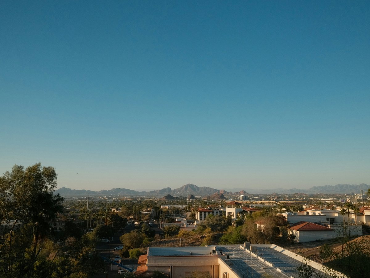
Phoenix sprawls across roughly 520 square miles of the Salt River Valley, pinned between mountain preserves on three sides and open desert to the west. The city's grid is ruthlessly logical. Central Avenue runs north-south as the zero line, with numbered streets heading east and numbered avenues heading west. Camelback Road, Indian School Road, and Thomas Road slice east-west at mile intervals. Most of the visitor-relevant action clusters along the Central Avenue and Camelback corridors, within about a 10-mile radius of downtown. The Valley Metro Light Rail connects downtown to Midtown, Uptown, and Tempe along a 28-mile line, which tends to be the easiest way to move between those areas without a car. Beyond that spine, you'll likely need to drive. The metro area technically includes Scottsdale, Tempe, and Mesa as separate cities, but the boundaries are invisible on the ground. A street in south Scottsdale feels like Phoenix because, functionally, it is. Worth noting that distances here deceive newcomers. Two neighborhoods that look close on a map might be a 25-minute drive apart, and summer temperatures above 110°F make walking between them genuinely inadvisable from June through September.
Neighborhoods
-
Downtown Phoenix
Downtown has been in a slow reinvention since the early 2010s. The area around 1st and Washington streets still has that government-district quiet during the day, with the Calvin C. Goode Municipal Building and Maricopa County courthouse anchoring blocks of wide, sun-bleached sidewalks. But the stretch along Jefferson Street near the Phoenix Convention Center has filled in with hotels, restaurants, and the Talking Stick Resort Arena (now Footprint Center). The pace picks up after 5 PM on weekdays and stays busy through weekends. You'll hear the light rail chiming at stops every 12 minutes or so. The buildings are a mix of 1960s concrete municipal boxes and newer glass-fronted hotels. The air smells like hot asphalt for most of the year, occasionally cut with roasting chiles from a street vendor near CityScape.
- Best for
- Convention-goers, first-time visitors who want walkable access to sports and museums, anyone relying on light rail instead of a rental car
- Key streets
- Washington Street between 1st Avenue and 3rd Street is the civic core. Jefferson Street runs past the convention center and Footprint Center. 1st Street and Central Avenue intersect at CityScape, a retail and dining plaza that tends to be the social center of gravity. Heritage Square at 6th Street and Monroe holds the Rosson House, an 1895 Victorian that looks almost absurd against the surrounding towers.
-
Roosevelt Row
Roosevelt Row, or RoRo to locals, runs along Roosevelt Street roughly between 7th Avenue and 16th Street. This is where Phoenix's art scene consolidated in the mid-2000s, and it still feels scrappy in places. Low-slung buildings covered in murals alternate with repurposed bungalows and the occasional new-build apartment block. First Fridays draw thousands of people to the galleries and pop-up vendors along Roosevelt and Grand Avenue, turning the neighborhood into a slow-moving street party from about 6 PM to 10 PM. On a regular Tuesday, though, it's quiet enough to hear the gravel crunch under your shoes. The food scene here leans creative and mid-range. Pizzeria Bianco at Heritage Square, which relocated from its original 7th Street spot, still draws 45-minute waits on weekend evenings. The coffee at Lux Central on Central Avenue has been a neighborhood institution since 2005.
- Best for
- Art-minded travelers, couples who prefer independent restaurants over chains, anyone who wants to walk between galleries, bars, and coffee shops without moving the car
- Key streets
- Roosevelt Street itself is the spine. Grand Avenue cuts diagonally from about 15th Avenue toward downtown and holds many of the galleries and studios. 1st through 5th Streets between Roosevelt and Portland have a cluster of murals that rotate with new commissions. The intersection of 5th Street and Roosevelt is probably the densest block for food and drink.
-
Arcadia
Arcadia sits between 44th Street and 56th Street, roughly bounded by Camelback Road to the north and Indian School Road to the south. This is Phoenix's version of a leafy residential enclave. The streets are lined with mature citrus trees, and in February and March, the smell of orange blossoms is genuinely overwhelming. You'll walk past 1950s ranch houses with deep lots, many of them renovated but still single-story, mixed with newer builds that push the square footage limits of the original parcels. Camelback Mountain looms at the north end, close enough that you can see hikers on the ridge from the restaurant patios along 44th Street. The food scene here has become one of the best in the metro. Postino on 44th Street, a wine bar in a converted post office, still fills every seat by 6 PM. The Hash Kitchen on Scottsdale Road near the neighborhood's eastern edge does a weekend brunch with a build-your-own Bloody Mary bar that pulls a crowd before 9 AM.
- Best for
- Food-focused travelers willing to drive, couples or small groups who prefer residential calm over downtown bustle, hikers who want Camelback Mountain trailheads within a 5-minute drive
- Key streets
- 44th Street between Camelback and Indian School is the commercial spine with restaurants, wine bars, and a Trader Joe's. The residential streets between 44th and 48th have the best citrus groves. Camelback Road heading east toward Scottsdale has the newer restaurant development, including the stretch near the Arcadia Farms complex.
-
Encanto-Palmcrest
Encanto is one of Phoenix's oldest residential districts, centered around Encanto Park near 15th Avenue and Encanto Boulevard. The homes here date mostly from the 1920s through 1940s. Spanish Colonial Revival, Tudor, and early ranch styles sit side by side on streets with actual canopy trees, which feels almost improbable in a desert city. The pace is slow. On weekend mornings, you'll hear screen doors and sprinklers and not much else. Encanto Park itself has a small lake with paddleboats, a public golf course called Encanto 9 with greens fees around $20, and a band shell that hosts concerts in the cooler months. The neighborhood is roughly 2 miles west of Central Avenue, close enough to downtown that a rideshare runs about $8 but far enough to feel removed from the convention-center energy. Restaurants are sparse within the neighborhood itself, but Central Avenue is a short drive east.
- Best for
- Travelers who prefer historic residential character over hotel districts, families with young children who want park access, anyone staying in a short-term rental who values quiet streets over walkable nightlife
- Key streets
- Encanto Boulevard between 7th and 15th Avenues for the best concentration of historic homes. Monte Vista Road parallels it one block south and has some of the neighborhood's largest lots. Palm Lane, a few blocks north, has been a popular walking route for decades. 15th Avenue heading south connects to the Willo Historic District.
-
Camelback Corridor and Biltmore
The Camelback Corridor runs along Camelback Road from about 20th Street to 44th Street, with the Biltmore area clustered near 24th Street. This is the upscale commercial spine of central Phoenix. The Arizona Biltmore hotel, designed in 1929 by Albert Chase McArthur with input from Frank Lloyd Wright, anchors the area with its textile-block facade and 39 acres of grounds. The surrounding blocks have filled with resort-style hotels, mid-rise office buildings, and shopping at Biltmore Fashion Park, an open-air mall with a Saks Fifth Avenue and a handful of restaurants facing a manicured lawn. The architecture is corporate-polished along Camelback Road itself, but the residential streets immediately south dip into 1960s neighborhoods with mature landscaping and block walls painted in desert tones. The sound profile is traffic and HVAC units. This is not a walking neighborhood in the way Roosevelt Row is. You drive to a destination, park, and then walk within a contained complex.
- Best for
- Business travelers, couples seeking resort-style stays with spa access, anyone who wants high-end dining and shopping without driving to Scottsdale
- Key streets
- 24th Street and Camelback Road is the anchor intersection. Biltmore Fashion Park stretches along Camelback between 24th and 26th Streets. The Arizona Biltmore hotel sits north of the road on Missouri Avenue. 20th Street heading south connects to the Camelback East Village and more mid-range dining options.
-
Old Town Scottsdale
Technically a separate city, but the boundary with Phoenix at 68th Street is invisible on the ground. Old Town Scottsdale clusters along Scottsdale Road between Camelback Road and Indian School Road. The western half along Main Street has a southwestern-kitsch tourist strip with turquoise jewelry shops, galleries selling bronze cowboy sculptures, and a few genuinely good Native American art dealers like the Heard Museum Shop satellite. The eastern half along Stetson Drive and the Waterfront development is newer, shinier, and oriented toward nightlife. On Friday and Saturday nights, the bars along Saddlebag Trail and 1st Avenue fill up with a crowd that skews mid-20s to early 30s. During the day, the sidewalks are manageable and you can duck into the Scottsdale Museum of Contemporary Art (SMoCA) on 2nd Street for $10. The Scottsdale Waterfront along the canal has a handful of patio restaurants where you'll feel the occasional breeze off the water.
- Best for
- Nightlife seekers in their 20s and 30s, gallery browsers, visitors who want walkable restaurants and bars concentrated in a compact area, anyone interested in southwestern and Native American art
- Key streets
- Scottsdale Road is the main artery. Main Street heading west from Scottsdale Road has the galleries and the more western-themed shops. Stetson Drive and the Entertainment District south of Camelback have the densest nightlife. The Scottsdale Waterfront along the Arizona Canal at Goldwater Boulevard has the upscale-casual dining cluster. Marshall Way between Indian School and 1st Avenue has the more serious galleries.
-
Tempe and Mill Avenue
Tempe wraps around Arizona State University's main campus, and Mill Avenue is its commercial backbone running south from Tempe Town Lake to about University Drive. The lake itself is a dammed section of the Salt River bed, about 2 miles long, with a paved path that joggers and cyclists use before dawn to beat the heat. Mill Avenue has a college-town feel that's gradually gentrifying. A few of the older spots remain, like Casey Moore's Oyster House in a converted 1910 bungalow at 9th Street and Ash Avenue, but newer apartment blocks and chain restaurants have filled gaps. The A Mountain (Hayden Butte) trailhead sits at the south end of Tempe Town Lake and offers a short, steep climb, maybe 15 minutes up, with a 360-degree view of the valley. During ASU's fall and spring semesters, Mill Avenue is loud and busy on weekend nights. Over summer break, the density drops noticeably.
- Best for
- Budget-conscious travelers who want walkable food and drink, anyone who likes college-town energy, cyclists and joggers who want the Tempe Town Lake path, light rail riders who want easy access to downtown Phoenix (about 20 minutes east on the line)
- Key streets
- Mill Avenue between Rio Salado Parkway and University Drive is the main strip. 5th Street and 6th Street heading east from Mill have some of the older, more interesting restaurants. Tempe Town Lake's north shore path is accessible from the Rio Salado parking areas near Scottsdale Road. Rural Road heading south from the lake passes through the ASU campus.
-
South Mountain and Laveen
South Mountain Park and Preserve covers more than 16,000 acres at Phoenix's southern edge, making it one of the largest municipal parks in the country. The surrounding neighborhoods, including Laveen to the west, are newer-build suburban developments that started filling in during the 2000s housing boom. The architecture is predominantly stucco-and-tile tract homes with small yards and block walls. It's quiet, residential, and not particularly walkable beyond the park trails. The tradeoff is proximity to the preserve. The Dobbins Lookout road climbs to an overlook at 2,330 feet with a view north across the entire valley. The National Trail covers 14.3 miles end to end and passes through saguaro-studded desert that feels genuinely remote despite being within city limits. The air here smells like creosote after rain, a sharp, clean scent that locals associate with monsoon season from July through September.
- Best for
- Hikers and mountain bikers who want trail access as a priority, budget travelers willing to trade walkability for lower hotel and rental prices, families with cars who prefer quieter residential surroundings
- Key streets
- Central Avenue dead-ends at the park entrance and continues as Summit Road up to Dobbins Lookout. 48th Street on the park's east side accesses the Desert Classic and National Trail trailheads. Baseline Road along the park's northern boundary has the nearest commercial strip, mostly chains and strip-mall restaurants. Laveen's commercial center clusters near 51st Avenue and Baseline.
-
Central Avenue Corridor and Midtown
Central Avenue north of downtown, roughly between McDowell Road and Northern Avenue, is where Phoenix transitions from government buildings to a commercial midrise corridor. The stretch between McDowell and Thomas has the Phoenix Art Museum, the Heard Museum at 2301 North Central, and the Burton Barr Central Library, a striking 1995 Will Bruder building with a crystal canyon of glass on its north face. Midtown proper sits between Camelback and Thomas. The restaurants along Central here tend toward local and independent. Windsor on Central Avenue near Osborn Road does a brunch that Phoenix food critics have praised for over a decade. The sidewalks are wider than downtown and lined with shade structures, which makes this one of the more tolerable walking corridors in summer, though "tolerable" still means 105°F in June. The light rail runs the length of Central Avenue, with stops roughly every half mile.
- Best for
- Museum visitors, anyone who wants to be between downtown and the Camelback corridor without committing to either, light rail commuters, solo travelers who prefer walkable cultural institutions
- Key streets
- Central Avenue is the backbone. The Heard Museum sits at the intersection of Central and Monte Vista Road. The Phoenix Art Museum occupies the block at Central and McDowell. The Melrose District on 7th Avenue between Indian School and Camelback has vintage shops and restaurants in a lower-key strip that draws a loyal local crowd.
FAQ
Is it possible to visit Phoenix without renting a car?
The Valley Metro Light Rail covers the most visitor-relevant corridor from downtown through Midtown and into Tempe, with stops near the convention center, museums, and Mill Avenue. That 28-mile line handles maybe 40% of what a first-time visitor wants to see. But neighborhoods like Arcadia, South Mountain, and most of Scottsdale sit well off the rail line. Rideshare costs between these areas typically run $12 to $20 each way. If your trip centers on downtown, Roosevelt Row, and Tempe, you can manage without a car. If you plan to hike Camelback or explore Scottsdale's galleries, you'll likely want one for at least part of your visit.
Which Phoenix neighborhoods are safest for walking at night?
Old Town Scottsdale, Mill Avenue in Tempe, and the CityScape area of downtown Phoenix all have enough foot traffic and lighting on weekend evenings to feel comfortable. Roosevelt Row is generally fine on First Fridays when thousands of people are out, but the surrounding blocks can be quiet and poorly lit on other nights. The Biltmore area and Arcadia are safe but car-oriented, so there isn't much reason to walk at night. Standard city awareness applies everywhere.
When is the best time of year to visit Phoenix?
October through April is the comfortable window. Daytime temperatures in January and February sit around 65 to 70°F, which is why the snowbird population from the Midwest and Canada peaks those months. Hotel rates follow the weather, with the highest prices from February through March during spring training season when 15 MLB teams play across the valley. June through August regularly hits 110 to 118°F, and outdoor activity before 7 AM or after 7 PM becomes the norm. The monsoon storms in July and August can be spectacular to watch but they also bring dust storms and flash flooding. November tends to offer the best balance of mild weather and moderate hotel rates, with daytime highs around 75°F.
Where should I stay if I want to be near hiking trails?
The Arcadia neighborhood puts you within a 5-minute drive of both the Echo Canyon and Cholla trailheads on Camelback Mountain. The Paradise Valley corridor north of Camelback Road has several resorts that sit at the base of Mummy Mountain and offer direct trail access from the property. For South Mountain's 16,000-acre preserve, staying near Baseline Road and Central Avenue keeps the main park entrance within about 10 minutes. Papago Park, which holds the Desert Botanical Garden and easier trails, is accessible from the Tempe or east Phoenix side near 64th Street and McDowell.
What is the food scene like across different Phoenix neighborhoods?
Arcadia along 44th Street has become the densest cluster of locally-owned restaurants, with spots like Postino, The Vig, and Beckett's Table drawing crowds most evenings. Roosevelt Row leans toward creative smaller operations and food trucks. Downtown has improved significantly since about 2015, with places like Bitter & Twisted Cocktail Parlour in the old Luhrs Tower and Majerle's Sports Grill near Footprint Center. Tempe's Mill Avenue mixes college-friendly spots with a few standouts like House of Tricks on 7th Street. Old Town Scottsdale ranges from tourist-trap southwestern grill rooms to genuinely good spots like Citizen Public House on 2nd Street. Mexican food is strong across the entire valley, but Los Dos Molinos near South Mountain on Central Avenue has been serving some of the hottest New Mexican-style red chile in the city since 1984.
Last verified by automated review (v1.7.2) on . What is automated review?