Las Vegas sprawls across the Mojave Desert floor in a loose grid, with Las Vegas Boulevard (the Strip) running roughly north-south as the spine most visitors never leave. But the city fans out well beyond that 4.2-mile corridor. To the east, you hit the older downtown core around Fremont Street, where Vegas actually started in 1905. West of I-15, the Chinatown district lines Spring Mountain Road for about 3 miles. South and west, suburban master-planned communities like Summerlin push toward Red Rock Canyon. Henderson anchors the southeast. The key thing to understand is that "Las Vegas" to a local means the whole valley, not the Strip. The Strip itself sits in the unincorporated township of Paradise, technically not even within city limits. Distances fool people here. The terrain is flat, the sky is enormous, and buildings sit far apart, so a place that looks walkable on a map might be a 40-minute trudge in 110°F heat. The RTC bus system and the 3.9-mile Las Vegas Monorail (running the east side of the Strip from MGM Grand to the SAHARA) handle some of that, but rideshare is how most locals move between districts.
Neighborhoods
-
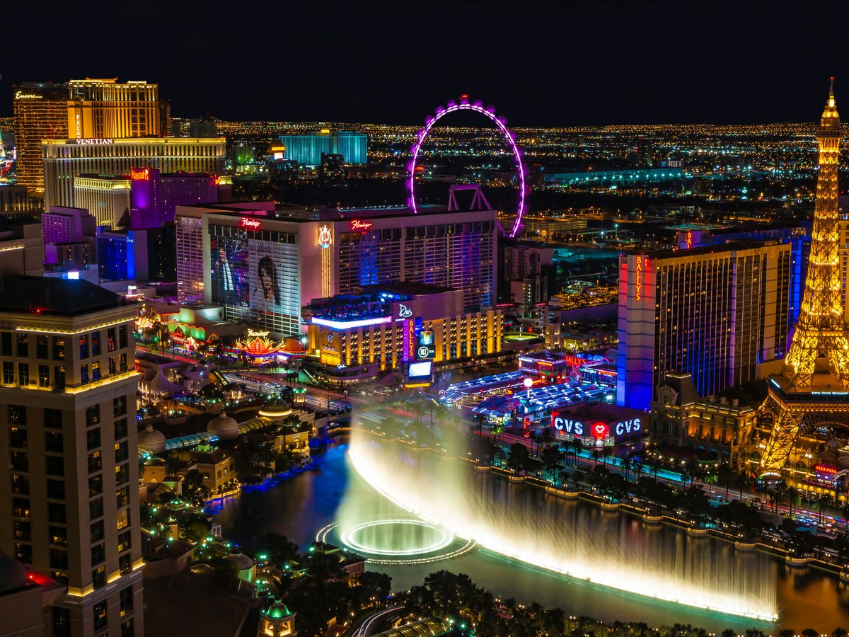
The Strip (Las Vegas Boulevard South)
A 4.2-mile stretch of megaresorts, each one a self-contained world. The north end near the STRAT tower feels slightly worn, with smaller casinos and wedding chapels. The center section between The Venetian and the Bellagio is the densest, loudest, most expensive block. Foot traffic here rarely thins, even at 3 a.m. South of Mandalay Bay, things get quieter fast. The noise level is constant, a low roar of slot machines bleeding through open casino doors, street performers with amplifiers, and the hydraulic hiss of the fountains at Bellagio cycling every 15 minutes after noon. The architecture is pure spectacle, each resort trying to outdo the next. There is no residential feel here whatsoever.
- Best for
- First-time visitors, nightlife seekers, convention-goers staying at a connected hotel, and anyone who wants the full sensory overload without renting a car
- Key streets
- Las Vegas Boulevard between Russell Road and Sahara Avenue is the main corridor. The Linq Promenade runs east off the boulevard to the High Roller observation wheel. Park Avenue connects Park MGM to T-Mobile Arena. For a slightly less frantic walk, the elevated bridge connecting Aria to The Shops at Crystals puts you above the crowds.
-
Downtown / Fremont Street
This is where Vegas started, and it still has that slightly rough, compressed energy the Strip has engineered away. Fremont Street Experience runs 5 blocks under a barrel-vault LED canopy that lights up with shows after dark. The casinos here (Golden Nugget, Binion's, El Cortez) are older, lower-ceilinged, and the carpet smells like decades of cigarette smoke. Minimum bets tend to run $5-10 versus $15-25 on the Strip. East of Las Vegas Boulevard, Fremont East Entertainment District stretches about 4 blocks with smaller bars, some with open-air patios. The Container Park at 707 Fremont Street has a 40-foot praying mantis sculpture out front that shoots real fire at night.
- Best for
- Budget-conscious gamblers, anyone who wants a grittier and more compressed Vegas experience, fans of cocktail bars and independent restaurants, and repeat visitors bored of the Strip
- Key streets
- Fremont Street from Main Street to 8th Street covers the action. Carson Avenue and Ogden Avenue run parallel one block north and south, with quieter bars. The 18b Arts District sits a few blocks south, centered on Main Street and Casino Center Boulevard between Colorado Avenue and California Avenue.
-
18b Arts District
South of Fremont, roughly bounded by Las Vegas Boulevard, Commerce Street, Colorado Avenue, and California Avenue, this warehouse district has been quietly filling with galleries, coffee roasters, and restaurants since the mid-2000s. The buildings are low, 1-2 story industrial boxes with corrugated metal facades. The pace here is genuinely slow compared to anything north of it. You'll find tattoo shops next to craft breweries next to vintage furniture dealers. First Friday, held on the first Friday of each month, draws several thousand people for gallery walks and food trucks along Main Street. The rest of the month, some of the galleries keep limited hours. Daytime foot traffic is sparse and the heat radiates off the asphalt, so most life happens after 5 p.m.
- Best for
- Creatives, photographers looking for industrial backdrops, anyone who wants a walkable district that feels nothing like a casino, and people staying downtown who want a 10-minute escape
- Key streets
- Main Street between California Avenue and Colorado Avenue is the gallery spine. Casino Center Boulevard runs parallel with more studios. The stretch of South 1st Street near Wyoming Avenue has newer restaurants. Grab a coffee at Makers & Finders at 1120 S Main Street, a Latin American cafe that roasts its own beans.
-
Chinatown (Spring Mountain Road)
Las Vegas Chinatown is not a compact downtown block like San Francisco's. It runs along Spring Mountain Road from about Valley View Boulevard west to Decatur Boulevard, roughly 3 miles of strip malls. The signage is multilingual, heavy on Chinese, Korean, Japanese, Filipino, and Vietnamese. This is widely considered the best food corridor in the Las Vegas Valley, period. The restaurants turn over fast, which keeps quality high. You might eat Sichuan at 8 p.m. and then walk to a Korean corn dog shop and a boba place before 9. The parking lots are chaotic. The architecture is purely functional, stucco strip-mall boxes, but the interiors of the best restaurants rival anything on the Strip.
- Best for
- Serious food enthusiasts, anyone tired of casino restaurant prices, night owls (many spots stay open until 2-3 a.m. or later), and visitors who want the local Las Vegas eating experience
- Key streets
- Spring Mountain Road is the only street that matters here. The plaza at 4215 Spring Mountain (Chinatown Plaza, with the ceremonial gate) was the original anchor. The strip malls between Arville Street and Decatur Boulevard have the densest concentration. Procyon Street, one block south, connects some of the newer plazas.
-
Summerlin
A 22,500-acre master-planned community on the western edge of the valley, bumping right up against Red Rock Canyon. Howard Hughes Corporation started developing it in 1990. The feel here is suburban Southwest, terra cotta and beige stucco homes with red tile roofs, wide boulevards, well-maintained parks, and very little foot traffic. Desert landscaping dominates. The air smells different out here, drier and slightly sage-scented from the desert scrub at the edges. Downtown Summerlin is an open-air mall at Sahara Avenue and the 215 Beltway with about 125 stores and restaurants. The Red Rock Casino Resort sits at the community's western border and is a locals' casino, noticeably quieter and cheaper than anything on the Strip.
- Best for
- Families, hikers and outdoor enthusiasts using Red Rock Canyon (the 13-mile scenic drive entrance is about 10 minutes away), people who want a quiet home base and don't mind a 25-minute drive to the Strip
- Key streets
- Town Center Drive and Pavilion Center Drive in Downtown Summerlin anchor the retail. Summerlin Parkway (SR 613) connects to US-95 and gets you to the Strip in about 20 minutes without traffic. Village Center Circle has more neighborhood restaurants. The trailhead for the Kraft Mountain Loop is about 15 minutes from most Summerlin homes.
-
Henderson
The second-largest city in Nevada (population around 322,000) sits southeast of the Strip and functions as its own municipality with its own downtown district along Water Street. The area around Water Street has seen a renovation push, with Henderson Events Plaza hosting free concerts and a farmer's market on Thursdays. The Green Valley neighborhood in the north end has ranch-style homes from the 1980s-90s, while Inspirada and Cadence in the south are newer, built after 2010. The feel is quiet residential. Lake Las Vegas, a 320-acre artificial lake about 20 minutes east, has a faux-Mediterranean village with a few restaurants and kayak rentals. The elevation rises slightly toward the southeast, and you get clearer views of the McCullough Range.
- Best for
- Families, long-term visitors who want apartment-style accommodations at lower rates, anyone visiting the Hoover Dam or Lake Mead (Henderson is the closest major residential area, about 30 minutes to the dam)
- Key streets
- Water Street between Lake Mead Parkway and Pacific Avenue is the walkable downtown core. Green Valley Parkway runs north-south through the older residential sections. Stephanie Street has a strip of local restaurants, including Thai and Mexican spots with genuine local followings. Eastern Avenue connects Henderson to the south end of the Strip in about 15 minutes.
-
University District (UNLV Area)
The blocks surrounding the University of Nevada, Las Vegas campus between Maryland Parkway and Swenson Street have that slightly worn college-town energy. The campus itself covers 332 acres, and the surrounding streets are lined with apartment complexes, taco shops, pho restaurants, and thrift stores. Maryland Parkway is the main commercial strip, and it is not pretty, aging strip malls and heavy traffic, but the food is cheap and real. You'll notice the demographic shift here immediately, younger, more diverse, less tourist. The Marjorie Barrick Museum on campus has free admission and a surprisingly strong collection of Mesoamerican and Southwestern art. Noise-wise, it is calmer than the Strip but not quiet. Emergency vehicle sirens from Sunrise Hospital on Maryland Parkway punctuate the evenings.
- Best for
- Budget travelers, students, anyone who wants to eat well for under $12 a meal, and visitors who prefer a residential neighborhood within a 10-minute rideshare to the Strip
- Key streets
- Maryland Parkway from Tropicana Avenue to Flamingo Road is the commercial spine. University Road borders the west side of campus. Naples Drive and Cottage Grove Avenue are quieter residential streets for short-term rentals. Paradise Road runs parallel to the west and connects to the Convention Center.
-
North Las Vegas
Often dismissed by tourists entirely, North Las Vegas is its own incorporated city north of downtown. The stretch along Las Vegas Boulevard North between Carey Avenue and Craig Road is working-class, with auto repair shops, tiendas, and taco trucks that serve some of the most honest Mexican food in the valley. The area near Craig Ranch Regional Park (628 acres, with a skate park and walking trails around a small lake) is the most family-oriented section. Aliante, a master-planned community in the northwest part, has its own casino (Aliante Casino + Hotel + Spa) and a notably quieter atmosphere. This is not a tourist destination, but it is real Las Vegas. The smell of mesquite smoke from backyard barbecues hangs in the air on weekend evenings.
- Best for
- Budget travelers who don't mind a 15-20 minute drive to the Strip, people looking for authentic Mexican and Salvadoran food, and visitors heading to Las Vegas Motor Speedway (which sits on the north edge)
- Key streets
- Las Vegas Boulevard North from Lake Mead Boulevard to Craig Road has the densest stretch of taquerias. Craig Road runs east-west and connects to I-15. Aliante Parkway in the master-planned section has the casino and the newer chain restaurants. Losee Road near Craig Ranch Park is the quieter residential area.
FAQ
Is it possible to visit Las Vegas without a car?
On the Strip itself, yes. The Las Vegas Monorail runs 3.9 miles along the east side from MGM Grand to SAHARA, and free trams connect Bellagio-to-CityCenter, Aria-to-Crystals, and Mandalay Bay-to-Excalibur. The RTC Deuce bus runs the full length of the Strip 24 hours a day ($8 for a 24-hour pass). Getting downtown from the Strip takes about 20 minutes on the Deuce. But reaching Chinatown, Summerlin, Henderson, or Red Rock Canyon without a car means relying on rideshare, which runs $12-25 each way depending on the destination and time. If you plan to leave the Strip more than twice, a rental car (often $35-60/day from the consolidated Rent-A-Car Center near the airport) pays for itself quickly.
Which neighborhood has the best food scene in Las Vegas?
Spring Mountain Road in Chinatown, and it is not close. The Strip has celebrity chef restaurants with $85 steaks and $22 cocktails, and some of them are genuinely excellent (the omakase at Kame by Masa Takayama in Aria runs about $300 and is worth it). But for volume, variety, and value, the 3-mile stretch of Spring Mountain from Valley View to Decatur has more interesting food per block than anywhere else in the valley. Late-night options stay open until 2-3 a.m. Expect to spend $15-30 per person at most spots. Downtown's Fremont East has a smaller but growing scene, with Carson Kitchen and Le Thai at 523 Fremont Street as standouts.
Where should families with kids stay in Las Vegas?
Summerlin and Henderson are the most family-oriented areas, with parks, quieter streets, and easy access to outdoor activities. On the Strip, the Mandalay Bay end (south Strip) tends to be calmer, and the Shark Reef aquarium and the pool's lazy river keep younger kids occupied. Circus Circus at the north end of the Strip has the Adventuredome indoor theme park (day passes around $20-40) and lower room rates, though the property is showing its age. Avoid booking directly on the center Strip between Flamingo Road and Spring Mountain Road if noise is a concern, that stretch does not quiet down until about 4 a.m.
How hot does Las Vegas actually get, and does it affect where to stay?
July and August average highs reach 106-108°F (41-42°C), and the pavement-level temperature on the Strip can feel 10-15 degrees hotter due to heat radiating off the concrete. Summerlin sits about 1,000 feet higher in elevation and tends to run 3-5°F cooler, with the Red Rock Canyon breeze in the evenings. The key consideration is walkability. In summer, walking more than 10-15 minutes outdoors between air-conditioned spaces is genuinely unpleasant. If you're visiting June through September, staying at a connected resort (The Venetian and Palazzo share an indoor walkway, as do Aria, Vdara, and Bellagio via CityCenter) reduces outdoor exposure. Locals time their errands before 10 a.m. or after 7 p.m. from June to September.
Is downtown Las Vegas safe for walking at night?
The Fremont Street Experience canopy area between Main Street and 4th Street is heavily monitored and well-lit, with private security supplementing LVMPD. Fremont East from 4th to 8th Street is busy on weekend nights and generally fine. South of Fremont toward the 18b Arts District, the blocks get quieter and darker past about 10 p.m. on weeknights, though First Friday events bring large crowds monthly. North of Fremont past Ogden Avenue, the mood shifts quickly. Street-level homelessness is visible in the blocks around the Courtyard Homeless Resource Center near Foremaster Lane. Stick to the lit commercial corridors and you will likely feel comfortable, but it does not have the engineered safety-bubble feel of the mid-Strip megaresorts.
Last verified by automated review (v1.7.2) on . What is automated review?