Mumbai stretches along a narrow peninsula that juts into the Arabian Sea, roughly 70 kilometers from north to south. The older, denser neighborhoods sit at the southern tip, around Colaba and Fort, where British-era stone buildings still line the streets. As you move north, the city loosens up a bit. Bandra and Juhu have more breathing room, more trees, more of a residential feel. Further north still, Andheri and Powai tend to feel like separate cities entirely. The Western Railway line and the Harbour line are your mental map here. Most visitors stick to South Mumbai or Bandra, and for good reason. South Mumbai has the historical weight, the museums, the Gateway of India. Bandra has the restaurants, the nightlife, the sea-facing promenades. The two areas sit about 20 kilometers apart, connected by a 45-minute taxi ride that can stretch to 2 hours during evening rush. Worth noting, Mumbai's neighborhoods often bleed into each other with no clear boundary. You might walk from Colaba into Fort without realizing you've crossed. The transitions are gradual, marked more by shifts in building height and street noise than by any signpost.
Neighborhoods
-
Colaba
Colaba sits at the very tip of the peninsula, anchored by the Gateway of India and the Taj Mahal Palace Hotel. The streets here have a slightly worn grandeur to them. Old apartment blocks with wrought-iron balconies stand next to tourist shops selling Kashmiri shawls. Leopold Cafe still draws backpackers, and the narrow lanes behind the Causeway stay busy until midnight. It's noisy, yes, but there's a particular energy here. Street vendors selling chaat next to galleries showing contemporary Indian art. The salt air drifts in from the harbour, and you can hear ferry horns from the docks at Apollo Bunder.
- Best for
- First-time visitors, history-focused travelers, solo backpackers comfortable with dense urban surroundings
- Key streets
- Colaba Causeway (Shahid Bhagat Singh Road) is the main commercial spine, running about 1.5 kilometers from the Regal Cinema down toward the tip. Mandlik Road has quieter cafes and galleries. Wodehouse Road leads east toward the members-only Royal Bombay Yacht Club.
-
Fort
Fort is Mumbai's old business district, and it still feels like one. The streets here are wider than Colaba's, lined with Victorian Gothic and Art Deco buildings that UNESCO recognized in 2018 as part of a World Heritage ensemble. During weekday lunch hours, office workers crowd the Irani cafes and South Indian restaurants along Horniman Circle. Weekends are quieter. You can actually hear pigeons. The Chhatrapati Shivaji Maharaj Terminus, with its gargoyles and stained glass, anchors the northeast edge. The architecture here is genuinely striking. Some of the buildings along DN Road still have their original cast-iron columns from the 1870s.
- Best for
- Architecture enthusiasts, photographers, business travelers who want walkable access to South Mumbai's commercial core
- Key streets
- Dadabhai Naoroji Road (DN Road) runs north-south through the district. Horniman Circle Garden is surrounded by a ring of neoclassical buildings and makes a good orientation point. Kala Ghoda, the art district, sits on the western edge, with galleries and the Jehangir Art Gallery within a few blocks of each other.
-
Marine Drive and Churchgate
Marine Drive is a 3.6-kilometer arc of Art Deco apartment buildings facing the Arabian Sea. Locals call it the Queen's Necklace because the streetlights trace a curved line at night. The promenade gets crowded after sunset, with families, couples, joggers, and vendors selling roasted peanuts in paper cones. The buildings along the seafront were mostly built between 1935 and 1940. Many still have their original rounded balconies and pastel facades, though the salt air has weathered them. Churchgate station sits at the northern end, feeding commuters onto the Western line. The neighborhood has a residential calm during the day that shifts to a social-gathering energy by evening.
- Best for
- Couples, anyone who wants a seafront walk within minutes of their hotel, visitors who plan to spend most of their time in South Mumbai
- Key streets
- Netaji Subhash Chandra Bose Road runs along the full length of Marine Drive. Veer Nariman Road connects Churchgate station to the seafront. The lanes behind Marine Drive, particularly around Dhobi Talao, have older residential blocks and small Maharashtrian restaurants.
-
Bandra West
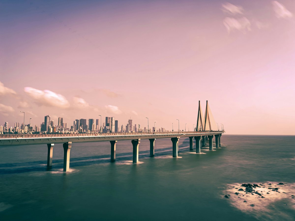
Bandra is where Mumbai loosens its collar. The neighborhood sits on the western coastline north of Mahim Creek, and it has a different feel from South Mumbai. More trees, more standalone bungalows (though developers are replacing them fast), more independent restaurants. The old Bandra village area around Hill Road and Chapel Road still has Portuguese-era houses with tiled roofs and wooden verandahs. The Bandra-Worli Sea Link, completed in 2010, connects it to South Mumbai across the bay. Carter Road's seafront path fills up around 6 PM with joggers and families. The restaurants here turn over faster than anywhere else in the city.
- Best for
- Foodies, nightlife seekers, longer-stay visitors who want a residential feel with good dining within walking distance
- Key streets
- Linking Road for shopping (clothing stalls, local brands, street food). Turner Road and 33rd Road for upscale restaurants and wine bars. Hill Road for the older Bandra, including Mount Mary Church and the Ranwar village conservation area. Carter Road for the evening promenade.
-
Dadar
Dadar is Marathi-speaking Mumbai's cultural center, and it operates at a pace that makes South Mumbai look relaxed. The flower market near Dadar station opens before dawn. By 6 AM, thousands of marigold garlands and jasmine strings are piled on the pavement, and the smell travels a full block. Shivaji Park, a large open maidan, hosted some of the earliest Indian independence rallies and remains a cricket ground where kids play until dark. The residential streets around Hindu Colony have old Maharashtrian apartment buildings with shared courtyards. Dadar gets overlooked by tourists, which is part of its appeal.
- Best for
- Travelers interested in Maharashtrian culture and food, those who want a non-touristy base with strong transit connections
- Key streets
- Senapati Bapat Marg leads to the flower market. Lady Jamshedji Road borders Shivaji Park on the south side. Gokhale Road connects Dadar's west side to its east, crossing both the Western and Central railway lines.
-
Juhu
Juhu is Mumbai's most recognizable beach neighborhood. The beach itself stretches about 6 kilometers along the coast, though the sand is dark and the water is not for swimming. What draws people is the atmosphere, especially after 5 PM. Chaat vendors set up stalls along the sand selling pav bhaji, bhel puri, and pani puri. The prices tend to be slightly inflated (a plate of bhel might run 80 to 100 rupees versus 40 elsewhere), but the setting is the point. The residential streets behind the beach have large bungalows. Several Bollywood actors live in the Juhu-Vile Parle area, and you might notice security guards and tinted SUVs outside certain gates. ISKCON's Hare Krishna temple sits on Juhu Tara Road, a large marble complex open to visitors.
- Best for
- Families with children, Bollywood-curious visitors, travelers who want beach proximity even if the beach itself is more social than scenic
- Key streets
- Juhu Tara Road runs parallel to the beach and has most of the hotels and restaurants. AB Nair Road connects to Vile Parle station. Gulmohar Road, in the JVPD Scheme area behind Juhu, has quieter residential lanes and a few standout restaurants.
-
Lower Parel
Lower Parel was a textile mill district until the 1980s. The old cotton mills, some dating to the 1870s, have been converted into offices, restaurants, and cultural spaces. Phoenix Mills became a shopping and entertainment complex in the early 2000s. The neighborhood now has a corporate feel during weekdays, with glass towers and lunch-hour crowds. But traces of the old mill culture remain. You can still see the tall brick chimneys of former mills between the newer buildings. The National Textile Corporation's old structures line parts of Senapati Bapat Marg. The restaurants here tend toward the expensive side, 1,500 to 3,000 rupees per person at the newer places.
- Best for
- Business travelers, visitors who want upscale dining and shopping without going to the suburbs, gallery-goers
- Key streets
- Senapati Bapat Marg is the main artery. Tulsi Pipe Road runs parallel and has more local restaurants at lower price points. The lanes around Kamala Mills Compound have a concentration of bars and restaurants, though the compound itself has had safety controversies.
-
Andheri
Andheri is Mumbai's most populated suburb, and it functions like a city within the city. Andheri West has Lokhandwala Complex, a residential enclave popular with TV and film industry workers. Versova, on Andheri's western coast, has a fishing village that predates the suburb by centuries. Andheri East has the MIDC industrial area and the international airport is technically in its jurisdiction. The noise level is high, the traffic is relentless, and the food options cover every regional Indian cuisine. Some of Mumbai's best Gujarati thali restaurants are on SV Road in Andheri West. The metro Line 1, which opened in 2014, connects Andheri to Ghatkopar in about 40 minutes.
- Best for
- Budget-conscious travelers who need airport proximity, visitors staying longer than a week who want affordable rent and good food variety
- Key streets
- SV Road is the main commercial road running through Andheri West. Linking Road (not to be confused with Bandra's Linking Road) connects to Lokhandwala. Yari Road in Versova leads to the beach and the remaining Koli fishing village. New Link Road has the newer restaurants and chain cafes.
-
Worli
Worli sits on a promontory between Lower Parel and the Sea Link to Bandra. It has some of Mumbai's priciest real estate. The Worli Sea Face road offers views across the bay to Bandra, and the sunsets from here are worth the autorickshaw ride. The neighborhood mixes old fishing-village lanes (the Worli Koliwada) with newer high-rises. The Nehru Centre and Nehru Planetarium sit at the southern end. Worli feels calmer than its neighbours, partly because fewer through-roads cross it. The air smells like salt water on most evenings. Construction noise from new towers is a near-constant backdrop, though.
- Best for
- Mid-to-high budget travelers wanting a quieter base between South Mumbai and Bandra, couples who prioritize sunset views
- Key streets
- Worli Sea Face (Annie Besant Road along the coastline) is the main draw. Dr. E. Moses Road connects to Lower Parel on the east. The lanes inside Worli Village, near the old Worli Fort (a small, mostly ruined Portuguese-era structure), are worth a walk.
-
Mahalaxmi and Tardeo
This corridor sits between South Mumbai and Lower Parel, marked by two landmarks that tell very different stories. The Mahalaxmi Dhobi Ghat is an open-air laundry where roughly 700 washers scrub clothes in concrete troughs. It's been operating since 1890. Across the road, the Mahalaxmi Racecourse hosts horse racing from November through April. The neighborhood around Tardeo has older apartment buildings, Parsi colonies with gated compounds, and narrow lanes with Irani bakeries. The Haji Ali Dargah, a mosque built on a small islet connected by a causeway, is accessible only at low tide.
- Best for
- Curious travelers who enjoy watching a city's working life, visitors who want a central location without the tourist density of Colaba
- Key streets
- Dr. E. Moses Road runs along the racecourse. Haji Ali Circle is the main traffic junction. Bhulabhai Desai Road (formerly Warden Road) has older upscale residences and a few art galleries. August Kranti Maidan, where the Quit India movement launched in 1942, is nearby.
FAQ
Where should a first-time visitor to Mumbai stay?
Colaba or Fort are the most practical choices for a first visit. Both neighborhoods are walkable, close to the Gateway of India, CSMT station, and the major museums. Hotels in Colaba range from budget guesthouses around 2,000 rupees per night to the Taj Mahal Palace at 25,000 and up. Fort has fewer hotels but stronger transit connections. If you're only in Mumbai for 2 to 3 days, staying in South Mumbai means you won't lose hours to traffic.
Is Bandra or South Mumbai better for restaurants and nightlife?
Bandra currently has more restaurant variety and a faster turnover of new openings. The strip along Turner Road and 33rd Road has wine bars, Japanese, Italian, and modern Indian restaurants within a few blocks of each other. South Mumbai's dining scene tends toward older institutions (Trishna in Fort for seafood, Britannia for Parsi food) and hotel restaurants. For nightlife specifically, Bandra and Lower Parel have more options. South Mumbai's bars tend to close earlier, by midnight or 1 AM, while Bandra's stretch later.
How do you get between South Mumbai and the western suburbs?
The Western Railway line runs from Churchgate station north through Bandra, Andheri, and beyond. Trains run every 3 to 5 minutes during peak hours and cost about 10 to 15 rupees for a one-way second-class ticket. The ride from Churchgate to Bandra takes around 30 minutes. Avoid the trains between 8:30 and 10:30 AM and 5:30 and 8 PM, when the carriages are severely overcrowded. Taxis and ride-hailing apps (Ola and Uber both operate in Mumbai) are the alternative, but traffic on the Western Express Highway can double travel times during rush hour. The Bandra-Worli Sea Link toll is 85 rupees one way for cars.
Which neighborhoods should budget travelers consider?
Dadar and Andheri both offer significantly lower accommodation costs than South Mumbai or Bandra. A decent guesthouse in Andheri West runs 1,200 to 2,500 rupees per night. Dadar has fewer tourist-oriented options but strong local food at low prices, and its station connects to both the Western and Central railway lines. Colaba still has some budget guesthouses in the 1,500 to 2,000 rupee range along the back lanes off the Causeway, though they tend to fill up between October and February.
Is Mumbai safe to walk around at night?
South Mumbai, Bandra West, and Marine Drive are generally walkable late into the evening. Marine Drive's promenade has people on it past midnight most nights. The main risk in Mumbai tends to be traffic rather than crime. Footpaths are uneven and sometimes nonexistent, so you'll find yourself walking on the road. Avoid poorly lit areas near railway tracks after dark, particularly in the central and eastern suburbs. Women traveling alone might want to use the dedicated ladies' compartments on local trains, which are less crowded and clearly marked.
When is the best time of year to visit Mumbai?
November through February offers the most comfortable weather, with daytime temperatures around 28 to 32 degrees Celsius and low humidity. This is also peak tourist season, so hotel prices rise 30 to 50 percent over monsoon rates. The monsoon runs from June through September, with heavy rainfall (Mumbai averages about 2,400 mm annually, most of it in these 4 months). Streets flood regularly during monsoon, particularly in low-lying areas like Hindmata in Dadar and Milan Subway near Andheri. That said, Mumbai in the rain has its own appeal. The city smells like wet earth and fried snacks, and the seafront during a storm is genuinely dramatic.
Last verified by automated review (v1.7.2) on June 23, 2026. What is automated review?