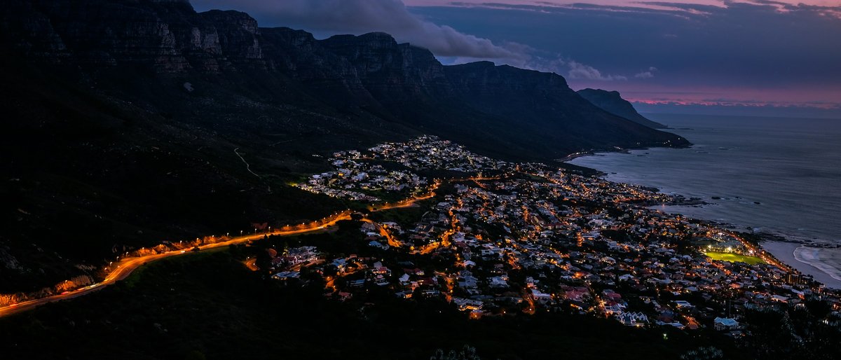
Cape Town sprawls across a narrow peninsula, pinched between the Atlantic on one side and False Bay on the other, with Table Mountain and its chain of lesser peaks running down the middle like a spine. That geography shapes everything. The City Bowl sits in a natural amphitheatre formed by Table Mountain, Signal Hill, Lion's Head, and Devil's Peak — most of the urban life concentrates here and along the Atlantic seaboard to the west. Head south down the peninsula and things get progressively quieter, more coastal, more village-like. The False Bay side — Simon's Town, Kalk Bay, Muizenberg — feels like a different world from the Atlantic side, warmer water and a slower pace. Getting around tends to involve driving or ride-hailing; public transport exists but it's patchy outside the MyCiTi bus routes. The key thing to understand: neighborhoods that look close on a map might be separated by a mountain pass. Camps Bay and Kalk Bay are maybe 30 km apart, but you're looking at 45 minutes in traffic. Where you base yourself matters more here than in most cities, because the peninsula's geography funnels everything onto a few corridors. Most first-timers do well somewhere in the City Bowl or along the Atlantic Seaboard, but the southern suburbs and False Bay coast have a pull that rewards the extra travel time.
Neighborhoods
-
City Bowl & CBD
The City Bowl is the commercial heart, but it has changed a lot in recent years. Long Street still has its backpacker reputation — late-night bars, fast food spots, a certain seediness after midnight — but the blocks around Bree Street and Shortmarket Street have become the real draw. Converted warehouses, independent restaurants, design studios. The buildings are a mix of art deco, Victorian, and modern glass, and the scale is human — nothing much over ten stories. Mornings are quiet. By lunch the sidewalk tables on Bree fill up. There is a persistent hum of construction somewhere, always. The mountain looms at the end of every street running south, which never quite stops being disorienting in the best way.
- Best for
- First-time visitors who want walkable access to restaurants, galleries, and the Company's Garden without needing a car for everyday errands
- Key streets
- Bree Street between Strand and Wale for restaurants and coffee. Shortmarket Street for smaller galleries. Long Street for secondhand bookshops and late-night bars. Wale Street connects you to Bo-Kaap on one end and the Company's Garden on the other.
-
Bo-Kaap
Steep cobblestone streets, houses painted in deep turquoise, salmon pink, mustard yellow. The colour gets all the Instagram attention, but Bo-Kaap is a living neighbourhood with a centuries-old Muslim community, not an open-air museum. The call to prayer drifts from the Auwal Mosque — the oldest in South Africa — and the smell of cardamom and cumin sits in the air, around midday. It is quieter than the City Bowl just a few blocks downhill. Foot traffic is mostly residents and a rotating cast of photographers. Some locals are welcoming, some are tired of the cameras. Be respectful of the fact that people live here. The architecture is Cape Dutch vernacular, low-slung and thick-walled, and the streets are narrow enough that sound carries.
- Best for
- Travellers interested in food culture and history, and those who prefer a residential feel over a hotel district. Limited accommodation options, so more of a place to spend a morning or afternoon than a base.
- Key streets
- Wale Street is the main artery. Chiappini Street has the colourful houses most people photograph. Rose Street and Dorp Street are quieter and worth wandering.
-
Gardens & Oranjezicht
Gardens sits just above the City Bowl on the lower slopes of Table Mountain. Leafy, residential, with Victorian-era houses behind wrought-iron fences and oak-lined streets. Oranjezicht blends into it further up the slope. The pace is slower — dog walkers, joggers heading to the Deer Park footpath, older couples at the Saturday Oranjezicht City Farm Market. There is a faint eucalyptus smell from the mountain vegetation above. The restaurants here tend to be neighbourhood spots rather than destination dining, with a few exceptions. Kloof Street runs along the boundary and is the social spine — coffee shops, wine bars, a bookshop, the Labia Theatre which still shows arthouse films in a converted church hall. At night Kloof gets lively without getting messy.
- Best for
- Couples and older travellers who want proximity to the city centre but prefer quiet streets and easy access to Table Mountain hiking trails
- Key streets
- Kloof Street is the main commercial stretch. Belmont Avenue in Oranjezicht for the Saturday morning market. Deer Park has footpaths connecting to Tafelberg Road and the cable car station.
-
Woodstock
Woodstock was a working-class, light-industrial neighbourhood for decades and it still carries that energy in its architecture — brick warehouses, corrugated iron, narrow Victorian terraces. Gentrification hit hard in the 2010s. Now those warehouses hold craft breweries, co-working spaces, and the Old Biscuit Mill, which hosts a Saturday food and design market that draws half the city. Albert Road is the main drag: tattoo parlours next to Somali shops next to a natural wine bar. It can feel a bit uneven — a slick gallery beside a boarded-up building. Some streets still feel rough, after dark and east of Victoria Road. During the day, though, Woodstock has a creative intensity that the more polished parts of the city lack. You can hear angle grinders from workshops next to artists' studios.
- Best for
- Younger travellers, creatives, and anyone who prefers a neighbourhood with grit over gloss. Good for self-catering stays in converted lofts.
- Key streets
- Albert Road is the central axis. Sir Lowry Road runs parallel and has some of the better coffee spots. The Old Biscuit Mill complex is on Albert Road near the Salt River end.
-
Observatory
Students from UCT, young professionals, musicians. Obs has been Cape Town's bohemian corner for decades, and while it has gotten pricier, it still has a scrappy energy. Lower Main Road is lined with secondhand shops, vinyl stores, Ethiopian restaurants, and dive bars that have not changed their decor since the 1990s. The streets behind Lower Main are residential — small cottages with overgrown gardens, cats everywhere. There is a constant low-level soundtrack of someone practicing guitar or a sound system testing. It is probably the most socially mixed neighbourhood in the city, which gives it a different texture from the more homogeneous Atlantic Seaboard. The Liesbeek River runs along one edge, and the towpath makes for a surprisingly pleasant walk.
- Best for
- Budget travellers, students, and anyone who values nightlife and live music over scenery. Good for longer stays.
- Key streets
- Lower Main Road for shops and restaurants. Station Road connects to the train line. Trill Road has some of the better restaurants.
-
Sea Point
Sea Point runs along the Atlantic coast just west of the City Bowl. It is dense and urban by Cape Town standards — apartment blocks from the 1960s and 70s, many of them still sporting their original pastel facades and metal balconies. The Sea Point Promenade is the defining feature: a paved walkway stretching from the V&A Waterfront to Bantry Bay, packed every evening with joggers, families, dog walkers. The sound of waves crashing against the rocks below the promenade is constant. Regent Road and Main Road run parallel inland — kosher delis, Korean restaurants, artisan gelato, old-school fishmongers. The neighbourhood has a lived-in, year-round feel that Camps Bay lacks. Wind can be fierce here, in summer when the southeaster blows.
- Best for
- Families and mid-range travellers who want ocean proximity, walkability, and a wide restaurant selection without resort prices
- Key streets
- The Sea Point Promenade from Mouille Point to Bantry Bay. Regent Road for restaurants and groceries. Main Road for everything from hardware stores to sushi.
-
Green Point & De Waterkant
Green Point sits between the V&A Waterfront and Sea Point, with the Cape Town Stadium as its landmark from the 2010 World Cup. It is tidy and well-maintained, with a mix of new apartment developments and older Cape Dutch-style houses. De Waterkant, tucked into the hillside above Green Point, has cobbled lanes and pastel Georgian cottages — it was the historic centre of Cape Town's LGBTQ+ community and still has that identity, though it has become more broadly gentrified. The Green Point Urban Park is pleasant — a landscaped park with indigenous gardens and a biodiversity garden, and it is rarely crowded. The area is walkable to the Waterfront, the stadium, and Sea Point, which makes it a practical base.
- Best for
- LGBTQ+ travellers, Waterfront visitors, and anyone wanting a central position with easy access to multiple areas on foot
- Key streets
- Somerset Road for restaurants and bars in De Waterkant. Main Road Green Point connects Sea Point to the city. The Fan Walk from the stadium leads to the Waterfront.
-
Camps Bay
Camps Bay is the beach everyone photographs — white sand, the Twelve Apostles mountain range as a backdrop, palm trees lining Victoria Road. It is beautiful in a way that feels almost excessive. The strip of restaurants and bars along Victoria Road faces the ocean, and on a summer evening the sunset light turns everything amber. That said, it is also the most tourist-saturated part of the city. Prices are high, parking is a war, and the water is cold — Atlantic cold, maybe 12 degrees on a good day. The residential streets climbing up behind the main strip are quieter, full of architect-designed houses with security gates. There is not much to do beyond beach, eat, drink, repeat. Which might be exactly what you want.
- Best for
- Travellers prioritising beach time and scenery above all else, and those who don't mind paying a premium for location
- Key streets
- Victoria Road is the main (and really only) commercial strip. Geneva Drive and Theresa Avenue climb into the residential hills above for views.
-
Kalk Bay
Kalk Bay is a fishing village that never quite stopped being a fishing village. The harbour still has working boats, and you can buy snoek and yellowtail straight off the trawlers some mornings. The main road — a single lane in each direction — is lined with antique shops, galleries, secondhand bookshops, and cafés squeezed into old fishermen's cottages. It is the kind of place where you walk in for coffee and leave three hours later carrying a vintage lamp. The pace is slower. The light on False Bay has a softer quality than the Atlantic side. Seals lounge on the harbour wall. The architecture is modest — low buildings, tin roofs, peeling paint that somehow looks intentional. It can feel quite busy on weekends, when Capetonians drive down for lunch, but weekday mornings are gentle.
- Best for
- Travellers who prefer character over convenience, and anyone who wants a small-town coastal feel within 30 minutes of the city centre
- Key streets
- Main Road through the village is the only street that matters — everything lines it. The harbour is at the south end.
-
Muizenberg
Muizenberg is where Cape Town learns to surf. The beach break is long and forgiving, the water is warmer than the Atlantic side (though still not tropical — maybe 18 degrees in summer), and the colourful beach huts that line the shore have become the area's trademark. The town itself is in the middle of a slow transformation — new coffee shops and surf outfitters alongside older businesses and some empty storefronts. It does not have the polish of Kalk Bay next door. Palmer Road has a cluster of restaurants and shops. The vibe is young, outdoorsy, slightly sandy at all times. Sunrise here, facing east over False Bay, is worth setting an alarm for.
- Best for
- Surfers, families with kids, budget-conscious beach lovers, and anyone who wants a laid-back base on the False Bay coast
- Key streets
- Palmer Road and York Road for the commercial cluster. Beach Road along the surf break. The path along the coast toward St James passes the colourful beach huts.
-
Constantia
Constantia sits in a green valley on the back side of Table Mountain, and it feels like countryside despite being 20 minutes from the city centre. This is wine country — Groot Constantia, Klein Constantia, Beau Constantia, and Eagles' Nest all sit within a few kilometres of each other on slopes that have been producing wine since the 1680s. The houses are large, the gardens are immaculate, and the roads wind through oak avenues. It is quiet in a way that other parts of Cape Town are not — birdsong and sprinklers rather than traffic. The restaurant scene here is strong but spread out. You need a car, or a willing designated driver, since the whole point is moving between wine estates.
- Best for
- Wine lovers, couples looking for a quieter base, and travellers who prefer green space and don't mind driving to the beach
- Key streets
- Constantia Main Road connects the estates. Spaanschemat River Road leads to Klein Constantia and Beau Constantia. Ladies Mile runs along the valley floor.
-
V&A Waterfront
The Waterfront is Cape Town's most visited destination, and that fact cuts both ways. It is a working harbour with a massive commercial development built around it — shops, restaurants, the Zeitz Museum of Contemporary Art Africa in a converted grain silo, a food market, an aquarium. It is clean, well-patrolled, and efficient. It is also, frankly, a mall with a view. The Zeitz MOCAA building alone is worth visiting for the architecture — Thomas Heatherwick carved the interior out of the old grain tubes, and the resulting spaces are cathedral-like. Table Mountain fills the southern view from almost everywhere. The actual harbour side, where fishing boats and tugs still operate, retains some authenticity. But you will hear more foreign accents than local ones, and prices reflect a captive audience.
- Best for
- Families with children, travellers who value safety and convenience, and anyone visiting the Zeitz MOCAA or departing for Robben Island
- Key streets
- Dock Road and Breakwater Boulevard are the main pedestrian routes. The Silo District around the Zeitz MOCAA is the most architecturally interesting section. The Clock Tower precinct near the swing bridge is where Robben Island ferries depart.
FAQ
What is the safest area to stay in Cape Town for first-time visitors?
The V&A Waterfront, Sea Point, and Green Point/De Waterkant are generally considered the safest areas, with well-lit streets and regular security presence. The City Bowl around Bree Street is also fine during the day and into the evening. Standard city precautions apply everywhere — don't flash expensive cameras or phones, be aware of your surroundings, and use Uber or Bolt rather than walking alone late at night. That said, Cape Town's safety reputation is often worse than the reality for tourists sticking to established areas. Ask your accommodation host about specific streets to avoid nearby.
Is it better to stay on the Atlantic side or the False Bay side?
Depends on what you want. The Atlantic side — Sea Point, Camps Bay, City Bowl — keeps you close to restaurants, nightlife, and the main sights, but the ocean water is bracingly cold (10-14°C year-round). The False Bay side — Muizenberg, Kalk Bay, Simon's Town — has warmer water, a quieter pace, and a more local feel, but you are 30 to 45 minutes from the city centre depending on traffic. Most first-timers choose the Atlantic side or City Bowl for convenience and switch to False Bay on subsequent visits. If surfing or a beach-town lifestyle matters to you, Muizenberg might be worth the trade-off from day one.
Do I need a car to get around Cape Town?
For the City Bowl, Sea Point, and Waterfront triangle, you can manage with Uber, Bolt, and the MyCiTi bus. Once you want to reach Constantia wine estates, Kalk Bay, Muizenberg, or anywhere on the peninsula, a car becomes close to essential. Ride-hailing works but gets expensive for cross-city trips. Renting a car is straightforward and parking is manageable outside of the CBD and Camps Bay in summer. Worth noting: driving over Chapman's Peak or along the False Bay coast is a genuine highlight, not just transport.
When is the best time of year to visit Cape Town?
The peak season is December through February — long sunny days, warm temperatures around 25-30°C, but also the strongest southeaster wind (locals call it the Cape Doctor) which can make beaches uncomfortable after midday. March and April are arguably better — the wind drops, the water is at its warmest, and the summer crowds thin out. June through August brings rain and cooler temperatures (10-16°C), but the city is green, the whale season begins, and accommodation prices drop significantly. September and October see wildflowers blooming on the West Coast, about an hour's drive north.
Which neighbourhood has the best food scene in Cape Town?
The City Bowl around Bree Street and Shortmarket Street currently has the densest concentration of quality restaurants — places like Pot Luck Club (technically in Woodstock, at the Old Biscuit Mill), Chef's Warehouse, and ASH. Sea Point has the most varied range, from Korean to kosher to Cape Malay. Woodstock is where newer, more experimental spots tend to open first. Constantia has the best fine dining in wine estate settings. Kalk Bay does seafood better than anywhere. There is not a single answer, but if you had to pick one base for eating out, the City Bowl gives you the most options within walking distance.
How long does it take to get from the airport to the main tourist areas?
Cape Town International Airport sits on the Cape Flats, roughly 20 km east of the city centre. In light traffic, the drive to the City Bowl or Sea Point takes about 20 to 25 minutes via the N2 highway. In rush hour — roughly 7-9am and 4-6:30pm on weekdays — that can stretch to 45 minutes or more. To Camps Bay, add another 10 minutes. To Muizenberg or Kalk Bay on the False Bay side, it is about 30 to 40 minutes depending on the route. Uber and Bolt both operate from the airport and are the most straightforward option.
Last verified by automated review (v1.7.1) on May 26, 2026. What is automated review?